VHZ-bar


  Long Valley Caldera Gravity Network

redrule


Gravity data format

References


The high precision gravity network

The Long Valley caldera gravity monitoring network is centered near Tom's Place (the primary reference station) and extends from the Sierra Nevada west of Lee Vining, California, southeastward to a station in the White Mountains east of Bishop, California (Figure 1). Most of the stations outside of Long Valley caldera are on crystalline bedrock outcrops, while volcanic flows or sediments underlie the stations within the caldera. The U.S. Geological Survey (USGS) occupied the network every summer from 1980 to 1985 (Jachens and Roberts, 1985; Roberts et al., 1988).

Earlier efforts at detecting and interpreting gravity changes in the Long Valley area were limited by the small amplitude of the accumulated signal, and the difficulty in correcting for the water table effect (Jachens and Roberts, 1985). Results from the 1998 and 1999 gravity survey demonstrate the intrusion of magma beneath the resurgent dome (Figure 2) and do not support perturbation in the hydrothermal system as the primary cause of uplift (Battaglia et al., 2002; Battaglia et al., 1999).

Gravity measurements were carried out using two LaCoste & Romberg gravimeters, model D26 and G8, simultaneously (Figure 3) . These two gravity meters are the original meters used previously by the USGS in Long Valley. They were refurbished and calibrated by LaCoste & Romberg in the spring of 1998. We measured the relative gravity at selected stations along closed loops starting from Tom's Place (benchmark MLEQB2), the primary reference station. Every station was occupied twice. Several stations of the gravity network had an alternate benchmark, so many points of the gravity network were measured four times a day using two different gravimeters. Data reduction included the removal of solid Earth-tides and daily gravimeter drift following the methods described in Jachens et al. (1982). The data were then examined for evidence of sudden changes of reading (or "tares") and corrections were applied when necessary. Finally, the measured relative gravity values were averaged using a least-squares method to obtain one gravity determination at each station, using software developed at the USGS, Menlo Park. The average error (1 standard deviation) for the gravity surveys was ± 8 mGal in 1998 and ±7 mGal in 1999. These estimates include contributions from errors in the tide correction and drift removal, as well as uncertainties in gravimeter readings caused by fluctuations in ambient temperature, vibrations experienced by the instruments, and errors in adjusting the meter bubble level (Jachens, 1979).


Gravity network
Gravity changes
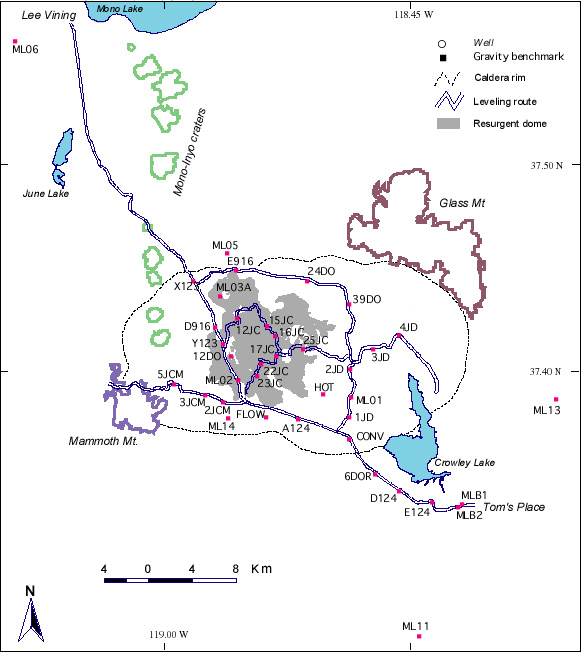
Figure 1. Long Valley gravity network. The network base station is MLEQB2 (Tom's Place). MLE06 (Lee Vining), MLEQ11 (Rock Creek) and MLEQ13 (Benton Crossing) are the network control stations.
[Back]

Figure 2. (a) Gravity changes from 1982 to 1999, values in mGal, error 1 St Dev; the gravity change reported here is the average of the 1999-82 and 1998-82 measured gravity changes (see Figure 5), corrected for fluctuations in the water table. (b) Uplift at gravity benchmarks from 1982 to 1999, values in mm, error 1 St Dev. (c) Residual gravity from 1982 to 1999, values in in mGal, error 1 St Dev. The white outline at the center of the caldera is the resurgent dome.
[Back]

measuring gravity

Figure 3. The author (M. Battaglia) measuring gravity at the Tom's Place base station with a LaCoste-Romberg G8 meter (July 1999)
[Back]


References

Battaglia M., Segall P., Roberts C., 2002. The mechanics of unrest at Long Valley caldera, California. 2. Constraining the nature of the source using geodetic and micro-gravity data. J. Volcanol. Geoterm. Res. (in press).
 
Battaglia M., Roberts C., Segall, P. 1999. Magma Intrusion Beneath Long Valley Caldera Confirmed by Temporal Changes in Gravity, Science, 285, 2119-2122.

Jachens, R., 1979. Temporal gravity changes as applied to studies of crustal deformation. Open-File Report - U. S. Geological Survey, OF 79-0370, 222-243.

Jachens, R., Roberts, C., 1985. Temporal and areal gravity investigations at Long Valley Caldera, California, J Geophys. Res. 90, 11,210-11,218.

Jachens, R., Spydell, R., Pitts, S., Dzurisin, D., Roberts, C., 1982. Temporal gravity variations at Mount St. Helens, March-May 1980. In Mullineaux, D. (Ed.): 1980 Eruptions Of Mount St. Helens, Washington, U. S. Geological Survey Professional Paper 1250, 175-181.

Roberts, C., Jachens, R., Morin, R., 1988. High-precision stations for monitoring gravity changes in Long Valley Caldera, California". Open-File Report - U.S. Geological Survey OF 88-0050.

[Top]


| Top | Home |

 valid-html401