
The Long Valley Caldera GIS Database
Digital Data Series DDS-81
2003
U.S. Department of the Interior
Gale A. Norton, Secretary
U.S. Geological Survey
Charles G. Groat, Director
1 Dept. of Geophysics, Stanford University, Stanford, CA 94305-2215.
a
Now at UC Berkeley Seismological
Laboratory, 215 McCone Hall, Berkeley CA
94720-4760. E-mail: battag@seismo.berkeley.edu
2 Branner Earth Sciences Library, Stanford University, Stanford, CA 94305
3 U.S. Geological Survey, 345 Middlefield Rd., MS977, Menlo Park, CA 94025
4
U.S. Geological Survey, P.O. Box 1360, Carnelian Bay, CA 96140
5 U.S. Geological Survey, Placer Hall, California CSUS,
Sacramento, CA 95819-6129
About this database
Systems requirements: IBM®-compatible computers running Windows®95 or higher or NT® 4.0 or higher with Intel® Pentium® or equivalent processor. MacIntosh® with PowerPC processor.
Software: Web browser; ArcInfo® or ArcView® with Spatial Analyst®, or any GIS that is capable of importing ArcView Shapefiles.
Acknowledgements
|
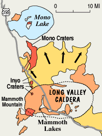
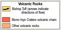
Long Valley Caldera at a Glance Fact Sheets about Long Valley Caldera References about Long Valley Caldera 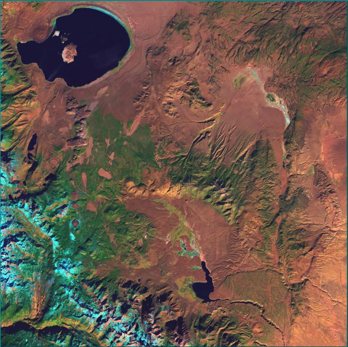
Landsat image of the Long Valley-Mono
Basin Region
|
|
Geologic maps
Monitoring dataGeodetic data
Leveling Topographic data |
|
|
Web users: |
|
| Long-term Outlook | |
| Observatory information |
Fact Sheets (2 pages) about Long Valley Caldera
- Living With a Restless Caldera | PDF| HTML |
- Future Eruptions in California's Long Valley Area--What's Likely? | PDF| HTML |
- Invisible CO2 Gas Killing Trees in the Mammoth Mountain Area | PDF | HTML|
References about Long Valley Caldera
- NEW Bibliography of Literature Pertaining to Long Valley Caldera and Associated Volcanic Fields , USGS Open-file report 00-221.
- Selected reading material
README File
- Read the README file from the CD-ROM (1_README.TXT; 52 KB).
![]()
![]()