Skip Links

USGS - science for a changing world

Data Series 838

Topographic Lidar Survey of Dauphin Island, Alabama and Chandeleur, Stake, Grand Gosier and Breton Islands, Louisiana, July 12–14, 2013

By Kristy K. Guy and Nathaniel G. Plant

Thumbnail of and link to report PDF (12.7 MB)Summary

This Data Series Report contains lidar elevation data collected on July 12 and 14, 2013, for Dauphin Island, Alabama, and Chandeleur, Stake, Grand Gosier and Breton Islands, Louisiana. Classified point cloud data—data points described in three dimensions—in lidar data exchange format (LAS) and bare earth digital elevation models (DEMs) in ERDAS Imagine raster format (IMG) are available as downloadable files. Photo Science, Inc., was contracted by the U.S. Geological Survey (USGS) to collect and process these data.

The lidar data were acquired at a horizontal spacing (or nominal pulse spacing) of 1 meter (m) or less. The USGS surveyed points within the project area from July 14–23, 2013, for use in ground control and accuracy assessment. Photo Science, Inc., calculated a vertical root mean square error (RMSEz) of 0.012 m by comparing 10 surveyed points to an interpolated elevation surface of unclassified lidar data. The USGS also checked the data using 80 surveyed points and unclassified lidar point elevation data and found an RMSEz of 0.073 m. The project specified an RMSEz of 0.0925 m or less.

The lidar survey was acquired to document the short- and long-term changes of several different barrier island systems. Specifically, this survey supports detailed studies of Chandeleur and Dauphin Islands that resolve annual changes in beaches, berms and dunes associated with processes driven by storms, sea-level rise, and even human restoration activities.

These lidar data are available to Federal, State and local governments, emergency-response officials, resource managers, and the general public.

First posted June 2, 2014

For additional information, contact:
Director, St. Petersburg Coastal and Marine Science Center
U.S. Geological Survey
600 Fourth Street South
St. Petersburg, FL 33701-4846
(727) 502–8000
http://coastal.er.usgs.gov/

Part or all of this report is presented in Portable Document Format (PDF). For best results viewing and printing PDF documents, it is recommended that you download the documents to your computer and open them with Adobe Reader. PDF documents opened from your browser may not display or print as intended. Download the latest version of Adobe Reader, free of charge.


Suggested citation:

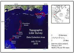
Guy, K.K., and Plant, N.G., 2014, Topographic lidar survey of Dauphin Island, Alabama and Chandeleur, Stake, Grand Gosier and Breton Islands, Louisiana, July 12–14, 2013: U.S. Geological Survey Data Series 838, 1 p., https://dx.doi.org/10.3133/ds838.

ISSN 2327-638X (online)


Contents

Description

Downloads

Regions

Individual Tiles

Acknowlegments


Accessibility FOIA Privacy Policies and Notices

Take Pride in America logo USA.gov logo U.S. Department of the Interior | U.S. Geological Survey
URL: http://pubsdata.usgs.gov/pubs/ds/0838/index.html
Page Contact Information: GS Pubs Web Contact
Page Last Modified: Monday, 28-Nov-2016 19:28:34 EST