Data Series 884
AbstractThe U.S. Geological Survey, in cooperation with the New Mexico Environment Department, compiled data from various sources to develop a dataset that can be used to conduct an assessment of the total dissolved solids in surface water and groundwater of the Palomas, Mesilla, and Hueco Basins in New Mexico and Texas, from below Caballo Reservoir, N. Mex., to Fort Quitman, Tex. Data include continuous surface-water discharge records at various locations on the Rio Grande; surface-water-quality data for the Rio Grande collected at selected locations in the Palomas, Mesilla, and Hueco Basins; groundwater levels and groundwater-quality data collected from selected wells in the Palomas and Mesilla Basins; and data from several seepage investigations conducted on the Rio Grande and selected drains in the Mesilla Basin.
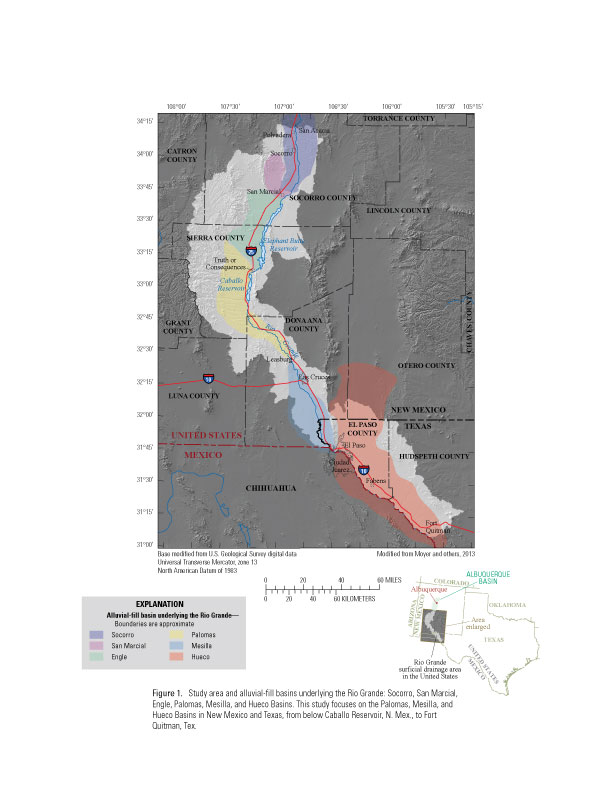
IntroductionSalinization of surface water and groundwater in the Rio Grande Basin has been recognized as a concern for water managers and water users for more than 100 years because of the potential to limit agricultural and municipal use (Moyer and others, 2013). Dissolved solids concentrations are more than five times greater in the Rio Grande at Fort Quitman, Texas, than about 250 miles upriver below Elephant Butte Reservoir, New Mexico. Major sources of salinity in the Rio Grande include the discharge of saline groundwater and mineral dissolution, with small contributions from evaporative processes and wastewater discharge to the river (Moyer and others, 2013). Changing hydrologic conditions in the Rio Grande Basin, such as reduced surface-water flows caused by drought conditions and lower groundwater levels caused by increased withdrawals, will likely result in changes in the concentration of dissolved solids in groundwater and surface water in the Rio Grande Basin, which could adversely affect agricultural, municipal, and environmental uses. Water Quality, Discharge, and Groundwater Levels in the Palomas, Mesilla, and Hueco BasinsThe U.S. Geological Survey (USGS), in cooperation with the New Mexico Environment Department (NMED), compiled water-quality, discharge, groundwater-level, and seepage data to develop a dataset that can be used to conduct an assessment of the total dissolved solids in surface water and groundwater of the Palomas, Mesilla, and Hueco Basins in New Mexico and Texas, from below Caballo Reservoir, N. Mex., to Fort Quitman, Tex. (fig. 1; tables 1–7). Data were collected in conjunction with several monitoring projects conducted by the USGS and other Federal, State, and local agencies, including continuous surface-water discharge records at various locations on the Rio Grande; surface-water-quality data for the Rio Grande collected at selected locations in the Palomas, Mesilla, and Hueco Basins; groundwater levels and groundwater-quality data collected from selected wells in the Palomas and Mesilla Basins; and data from several seepage investigations conducted on the Rio Grande and selected drains in the Mesilla Basin.
Though salinization increases in the Rio Grande downstream from the headwaters (Moyer and others, 2013), this study focuses on the area from below Caballo Reservoir, N. Mex., to Fort Quitman, Tex. (fig. 1). Data collected by the USGS have been reviewed and finalized by following standard USGS protocols (U.S. Geological Survey, 2006; Wagner and others, 2006; Turnipseed and Sauer, 2010; Cunningham and Schalk, 2011; Wilde and Radtke, variously dated). Data collected by other agencies are assumed to have been reviewed for accuracy and correctness by the source agency. Selected data from the Bureau of Reclamation and NMED are available through the USGS National Water Information System (NWIS) database (http://waterdata.usgs.gov/nwis); data obtained from other agencies are coded with the name of the source agency (tables 1–7). Station numbers are USGS station identification numbers unless otherwise indicated (tables 1–7). AcknowledgmentsThis report was prepared in collaboration with the New Mexico Office of the State Engineer. References CitedCunningham, W.L., and Schalk, C.W., comps., 2011, Groundwater technical procedures of the U.S. Geological Survey: U.S. Geological Survey Techniques and Methods 1–A1, 151 p. [Available at https://pubs.usgs.gov/tm/1a1/.] Gunn, M.A., and Roark, D.M., in press, Seepage investigation on the Rio Grande from below Caballo Reservoir, New Mexico, to El Paso, Texas, 2012: U.S. Geological Survey Scientific Investigations Report 2014–5197. Hendricks, E.L., 1964, Compilation of records of surface waters of the United States, October 1950 to September 1960: U.S. Geological Survey Water-Supply Paper 1732, 574 p. [Available at https://pubs.usgs.gov/wsp/1732/report.pdf.] Moyer, D.L., Anderholm, S.K., Hogan, J.F., Phillips, F.M., Hibbs, B.J., Witcher, J.C., Matherne, A.M., and Falk, S.E., 2013, Knowledge and understanding of dissolved solids in the Rio Grande—San Acacia, New Mexico, to Fort Quitman, Texas, and plan for future studies and monitoring: U.S. Geological Survey Open-File Report 2013–1190, 55 p. [Available at https://pubs.usgs.gov/of/2013/1190/.] Texas Water Development Board, 2003, A field manual for groundwater sampling: Texas Water Development Board User Manual 51, 47 p. [Available at http://www.twdb.state.tx.us/publications/reports/manuals/UM-51/FieldManual.pdf.] Turnipseed, D.P., and Sauer, V.B., 2010, Discharge measurements at gaging stations: U.S. Geological Survey Techniques and Methods, book 3, chap. A8, 87 p. [Available at https://pubs.usgs.gov/tm/tm3-a8/.] U.S. Geological Survey, 2006, Collection of water samples (ver. 2.0): U.S. Geological Survey Techniques of Water Resources Investigations, book 9, chap. A4, September 2006, accessed May 22, 2013, at https://pubs.water.usgs.gov/twri9A4/. Wagner, R.J.; Boulger, R.W., Jr.; Oblinger, C.J.; and Smith, B.A., 2006, Guidelines and standard procedures for continuous water-quality monitors—Station operation, record computation, and data reporting: U.S. Geological Survey Techniques and Methods 1–D3, 51 p., 8 attachments, accessed April 10, 2006, at https://pubs.water.usgs.gov/tm1d3. Wilde, F.D., and Radtke, D.B., eds., variously dated, Field measurements: U.S. Geological Survey National Field Manual for the Collection of Water-Quality Data, Techniques of Water-Resources Investigations, book 9, chap. A6. [Available at http://water.usgs.gov/owq/FieldManual/Chapter6/Ch6_contents.html.] |
First posted November 4, 2014
For additional information contact: Part or all of this report is presented in Portable Document Format (PDF). For best results viewing and printing PDF documents, it is recommended that you download the documents to your computer and open them with Adobe Reader. PDF documents opened from your browser may not display or print as intended. Download the latest version of Adobe Reader, free of charge. More information about viewing, downloading, and printing report files can be found here. |
|||||||||||||||||||||||||||||||||||||||||||||||||||||||||||||
McKean, S.E., Matherne, A.M., and Thomas, Nicole, 2014, Water quality, discharge, and groundwater levels in the Palomas, Mesilla, and Hueco Basins in New Mexico and Texas from below Caballo Reservoir, New Mexico, to Fort Quitman, Texas, 1889–2013: U.S Geological Survey Data Series 884, https://dx.doi.org/10.3133/ds884.

![]() U.S. Department of the Interior |
U.S. Geological Survey
U.S. Department of the Interior |
U.S. Geological Survey
URL: http://pubsdata.usgs.gov/pubs/ds/0884/index.html
Page Contact Information: GS Pubs Web Contact
Page Last Modified: Monday, 28-Nov-2016 20:29:48 EST