 Abstract Abstract
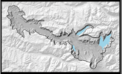
The lateral blast, debris avalanche, and lahars of the May 18th, 1980, eruption of Mount St. Helens, Washington, dramatically altered the surrounding landscape. Lava domes were extruded during the subsequent eruptive periods of 1980–1986 and 2004–2008. More than three decades after the emplacement of the 1980 debris avalanche, high sediment production persists in the North Fork Toutle River basin, which drains the northern flank of the volcano. Because this sediment increases the risk of flooding to downstream communities on the Toutle and Cowlitz Rivers, the U.S. Army Corps of Engineers (USACE), under the direction of Congress to maintain an authorized level of flood protection, built a sediment retention structure on the North Fork Toutle River in 1989 to help reduce this risk and to prevent sediment from clogging the shipping channel of the Columbia River. From September 16–20, 2009, Watershed Sciences, Inc., under contract to USACE, collected high-precision airborne lidar (light detection and ranging) data that cover 214 square kilometers (83 square miles) of Mount St. Helens and the upper North Fork Toutle River basin from the sediment retention structure to the volcano's crater. These data provide a digital dataset of the ground surface, including beneath forest cover. Such remotely sensed data can be used to develop sediment budgets and models of sediment erosion, transport, and deposition. The U.S. Geological Survey (USGS) used these lidar data to develop digital elevation models (DEMs) of the study area. DEMs are fundamental to monitoring natural hazards and studying volcanic landforms, fluvial and glacial geomorphology, and surface geology. Watershed Sciences, Inc., provided files in the LASer (LAS) format containing laser returns that had been filtered, classified, and georeferenced. The USGS produced a hydro-flattened DEM from ground-classified points at Castle, Coldwater, and Spirit Lakes. Final results averaged about five laser last-return points per square meter. As reported by Watershed Sciences, Inc., vertical accuracy is 10 centimeters (cm) at the 95-percent confidence interval on bare road surfaces; however, over natural terrain, USGS found vertical accuracy to be 10–50 cm. This USGS data series contains the bare-earth lidar data as 1- and 10-meter (m) resolution Esri grid files. Digital-elevation data can be downloaded (1m_DEM.zip and 10m_DEM.zip), as well as a 1-m resolution hillshade image with pyramids (1m_hillshade.zip). These geospatial data files require geographic information system (GIS) software for viewing.
|
First posted December 15, 2014
- Delivery Report PDF (13.4 MB)
Report by Watershed Sciences, Inc., under contract to USACE, on high-precision airborne lidar data collected September 16–20, 2009
- 1m DEM ZIP (572 MB)
Digital-elevation data using bare-earth lidar data as 1-m resolution Esri grid files. Refer to the Readme and Metadata files for more information.
This publication is online only
Part or all of this report is presented in Portable Document Format (PDF). For best results viewing and printing PDF documents, it is recommended that you download the documents to your computer and open them with Adobe Reader. PDF documents opened from your browser may not display or print as intended. Download the latest version of Adobe Reader, free of charge.
|

