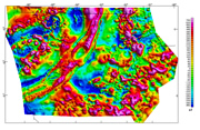
Magnetic anomalies are due to variations in the Earth's magnetic field caused
by the uneven distribution of magnetic minerals (primarily magnetite)
in the rocks that make up the upper part of the Earth's crust. The features
and patterns of the magnetic anomalies can be used to delineate details
of subsurface geology, including the locations of buried faults and magnetite-bearing
rocks and the depth to the base of sedimentary basins. This information
is valuable for mineral exploration, geologic mapping, and environmental
studies.
The Iowa magnetic map is constructed from grids that combine information collected
in nine separate magnetic surveys conducted between 1953 and 1972. The
data from these surveys are of varying quality. The design and specifications
(terrain clearance, sampling rates, line spacing, and reduction procedures)
varied from survey to survey depending on the purpose of the project
and the technology of that time. Every attempt was made to acquire the
data in digital form. All survey grids have been continued to 305 m (1,000
ft) above ground and merged together to form the State compilation.
|

