
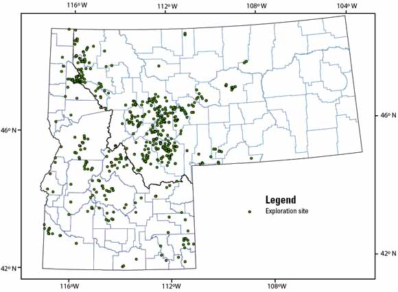
Location of mineral exploration sites in Idaho and Montana between 1980 and 1997 (from figure 1).
|
This report describes a relational database containing information about mineral exploration projects in the States of Idaho and Montana for the years 1980 through 1997 and a spatial (geographic) database constructed using data from the relational database. The focus of this project was to collect information on exploration for mineral commodities with the exception of sand, gravel, coal, geothermal, oil, and gas. The associate databases supplied with this report are prototypes that can be used or modified as needed. The following sources were used to create the databases—serial mining periodicals; annual mineral publications; mining company reports; U.S. Bureau of Mines (USBM) and U.S. Geological Survey (USGS) publications; an Idaho mineral property data base developed by Dave Boleneus, USGS, Spokane, Washington; Montana state publications; and discussions with representatives of Montana, principally the Montana Bureau of Mines and Geology and the Department of Environmental Quality. Fifty commodity groups were reported between the 596 exploration projects identified in this study. Precious metals (gold, silver, or platinum group elements) were the primary targets for about 67 percent of the exploration projects. Information on 17 of the projects did not include commodities. No location could be determined for 51 projects, all in Idaho. During the time period evaluated, some mineral properties were developed into large mining operations (for example Beal Mountain Mine, Stillwater Mine, Troy Mine, Montana Tunnels Mine) and six properties were reclaimed. Environmental Impact Statements were done on four properties. Some operating mines either closed or went through one or more shutdowns and re-openings. Other properties, where significant resources were delineated by recent exploration during this time frame, await the outcome of important factors for development such as defining additional reserves, higher metal prices, and the permitting process. Many of these projects examined relatively minor mineral occurrences. Approximately half of the exploration projects are located on Federal lands and about 40 percent were on lands managed by the U.S. Forest Service. More than 75 percent of the exploration occurred in areas with significant previous mineral activity. |
| File
Name |
File
Type and Description |
File
Size |
| | ||
| TEXT |
||
| The main text of this paper as an 80-page PDF file | 3 MB
| |
| Readme file as an ASCII text file | 56 KB
| |
| Metadata as an ASCII text file | 64 KB
| |
| DATA PACKAGE |
||
| Package of data for this report in a Zip file | 664 KB compressed (opens to 3 MB)
| |
For questions about the content of this report, contact David Buckingham
| Help
| PDF help
| Publications main page |
This report is only available online.