Landslide Hazards Program
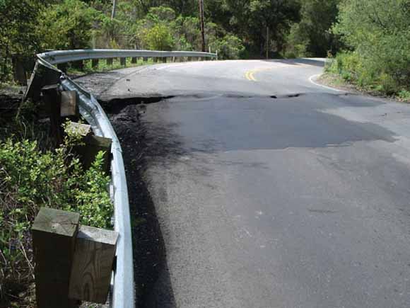
Lateral displacement of roadway at southern margin of landslide on April 28, 2006 (photograph by Katerina Rousseva, graduate student at San Jose State University) (from figure 5B)
Many different types of landslide occur in the Santa Cruz Mountains of San Mateo County, Calif. (Brabb and Pampeyan, 1972); most slope movement is triggered by strong earthquakes, heavy rainfall, or shoreline erosion. In this area, shallow landslides of loose soil and rock, which may transform into debris flows, commonly occur during individual storms when rainfall exceeds a threshold of intensity and duration (Cannon and Ellen, 1985; Wieczorek and Sarmiento, 1988; Wilson and Wieczorek, 1995). In contrast, deeper rotational and translational slides (Varnes, 1978) typically begin to move only after days to weeks or months of heavy rain. Once started, they can continue to move for months during and after a heavy rainfall season, for example, the Scenic Drive landslide at La Honda, Calif. (Jayko and others, 1998; Wells and others, 2005, 2006). Although the rainfall characteristics triggering rapid, shallow landslides have been documented (Wieczorek, 1987; Cannon and Ellen, 1988), the rainfall conditions leading to repeated deeper-seated slope movements are less well known.
The Weeks Creek landslide (Adam, 1975), near the western crest of the Santa Cruz Mountains north of La Honda in San Mateo County (fig. 1), consists of a large prehistoric section containing a historically active section; both sections have earthflow morphologies. The entire landslide mass, which extends about 1,000 m westward from an elevation of 220 m down to an elevation of 120 m, is about 300 to 370 m wide (Cole and others, 1994); The prehistoric section of the landslide is about 30 m deep and approximately 10 million m3 in volume (Cole and others, 1994). The smaller, historically active portion of the Weeks Creek landslide (fig. 1) is only approximately 500 m long, 200 m wide, and 13 m deep (Cole and others, 1994). Near the landslide, the Santa Cruz Mountains consist of tightly folded, Tertiary sedimentary bedrock materials of the Butano sandstone and San Lorenzo Formations (Eocene through Lower Oligocene). These sedimentary bedrock materials are locally intruded by Oligocene diabase and capped by Oligocene through Miocene basalt of the Mindego Formation (Brabb, 1980; Cole and others, 1994). Within the active landslide, as documented from multiple borings by Cole and others (1994), deeply weathered mudstone and sandstone of the San Lorenzo Formation extends to a depth of about 10 to 13 m, where the active shear zone is located. Beneath this, within the deeper prehistoric landslide, mudstone extends to a depth of about 24 to 32 m and is underlain by strong diabase bedrock. The basal rupture surface of the prehistoric landslide is located near the mudstone/diabase contact (Cole and others, 1994).
The historically active section of the Weeks Creek landslide, which is crossed by the La Honda road (California Highway 84, fig. 1), was first noticed to partially move during the great 1906 San Francisco earthquake (Lawson, 1908). It has moved repeatedly over the ensuing years but generally only during wet rainy seasons. For some of these active years, ground cracks and lateral displacements were recorded by local residents Walter Jodicke and Chris Pearson, as well as by U.S. Geological Survey (USGS) personnel. In spring 2006, fresh ground cracks were noted in parts of the prehistoric, previously inactive section of the landslide. In this report, we present daily rainfall measurements from 1973 through 2006 obtained at the landslide site and summarize available observations of slope movement over that period. In addition, we present more detailed observations of rainfall, ground-water pressure, and slope movement for three water years spanning the period 1981-1984. We conclude with some preliminary observations about rainfall and slope movement at this site.
Download the text for this report (ds276_text.pdf; 3.9 MB).
Go to the Data folder The 33 data files are provided here in three formats: comma-separated values (.csv), Microsoft Word (.doc), and Portable Document Format (.pdf). Each of the formats is available as a compressed file (.zip) that contains all 33 data files for that format (ds276_data folder; 8.3 MB total).
For questions about the content of this report, contact Gerry Wieczorek.
Suggested citation and version history
| Help
| Publications main page | Western Data Series reports |
| Geologic Division |
Landslide Hazards Program
|
This publication is available only on the Web.

![]() U.S. Department of the Interior | U.S. Geological Survey
U.S. Department of the Interior | U.S. Geological Survey
URL: https://pubs.usgs.gov/ds/2007/276/
Page Contact Information: Michael Diggles
Page Last Modified: January 28, 2008
