Western Mineral Resources
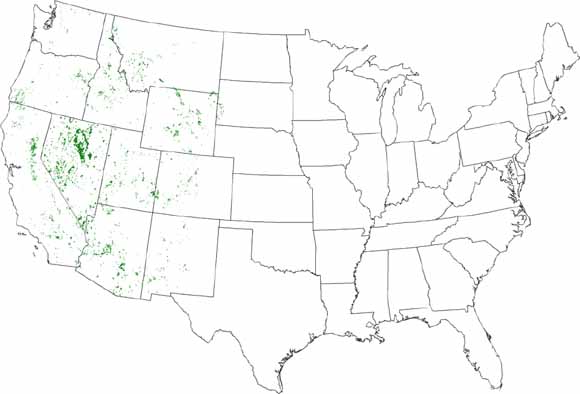
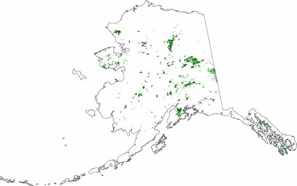
The Public Land spatial data sets (shapefile) contains Public Land Survey section polygons that had mining claims recorded in the U.S. Bureau of Land Management's LR2000 database as of December 31, 2010 (from a March 1, 2011 data extraction) for the period from 1976 to 2010 in Arizona, Arkansas, California, Colorado, Florida, Idaho, Montana, Nebraska, New Mexico, Nevada, North Dakota, Oregon, South Dakota, Utah, Washington, and Wyoming. Alaska was not updated in version 4.
Several statistical compilations of mining claim activity on Federal land derived from the Bureau of Land Management's LR2000 database have previously been published by the U.S Geological Survey (USGS). The work in the 1990s did not include Arkansas or Florida. None of the previous reports included Alaska because it is stored in a separate database (Alaska Land Information System) and is in a different format. This report includes data for all states for which there are Federal mining claim records, beginning in 1976 and continuing to 2010, except Alaska, which only had data to 2007.
The statistics compiled from the databases are counts of the number of active mining claims in a section of land each year from 1976 to 2010 for all states within the United States (exception: to 2007 for Alaska). Claim statistics are subset by lode and placer types, as well as a dataset summarizing all claims including mill site and tunnel site claims. One table presents data by case type, case status, and number of claims in a section. This report includes a spatial database for each state in which mining claims were recorded, except North Dakota, which only has had two claims. A field is present that allows the statistical data to be joined to the spatial databases so that spatial displays and analysis can be done by using appropriate geographic information system (GIS) software.
The data show how mining claim activity has changed in intensity, space, and time. Variations can be examined on a state, as well as a national level. The data are tied to a section of land, approximately 640 acres, which allows it to be used at regional, as well as local scale. The data only pertain to Federal land and mineral estate that was open to mining claim location at the time the claims were staked.
| File
Name |
File
Type and Description |
File
Size |
| | ||
| TEXT |
||
| Details of changes to v. 1.0 text linked below as a 6-page PDF file | 184 kB
| |
| The main text of this paper as a 31-page PDF file; no changes for v. 4.0 | 438 kB
| |
| Metadata as an ASCII text file | 16 kB
| |
| DATA PACKAGE |
||
| Package of data from all 16 states in a Zip file | 40.9 MB compressed (opens to 551 MB)
| |
| DATA FOLDERS
Each of these folders contains both uncompressed data and the same data compressed in a Zip file. A map showing claim locations is also provided as a PDF in each folder. |
||
- - - - - - - - - - - - - - - |
35 MB |
|
- - - - - - - - - - - - - - - |
60.3 MB |
|
- - - - - - - - - - - - - - - |
2.1 MB |
|
- - - - - - - - - - - - - - - |
79.8 MB |
|
- - - - - - - - - - - - - - - |
45.9 MB |
|
- - - - - - - - - - - - - - - |
1.5 MB |
|
- - - - - - - - - - - - - - - |
38.7 MB |
|
- - - - - - - - - - - - - - - |
30.9 MB |
|
- - - - - - - - - - - - - - - |
0.6 MB |
|
- - - - - - - - - - - - - - - |
115.4 MB |
|
- - - - - - - - - - - - - - - |
29 MB |
|
- - - - - - - - - - - - - - - |
23.9 MB |
|
- - - - - - - - - - - - - - - |
6.3 MB |
|
- - - - - - - - - - - - - - - |
59.4 MB |
|
- - - - - - - - - - - - - - - |
12.1 MB |
|
- - - - - - - - - - - - - - - |
51.4 MB |
|
For questions about the content of this report, contact Doug Causey
Suggested citation and version history
Download a free copy of the current version of Adobe Reader.
| Help
| PDF help
| Publications main page | Western Data Series reports |
| Geologic
Division | Western Mineral Resources
|
Version 4.0 is only available online. Version 1.0 is also available on CD-ROM from:
USGS Information Services, Box 25286,
Federal Center, Denver, CO 80225
telephone: 888-ASK-USGS; e-mail: infoservices@usgs.gov

![]() U.S. Department of the Interior |
U.S. Geological Survey
U.S. Department of the Interior |
U.S. Geological Survey
URL: http://
pubsdata.usgs.gov
/pubs/ds/2007/290/index.html
Page Contact Information: USGS Publications Team
Page Last Modified: Monday, 28-Nov-2016 12:31:13 EST