![[Link to USGS home page]](site/volcban2.gif)
INTRODUCTION |
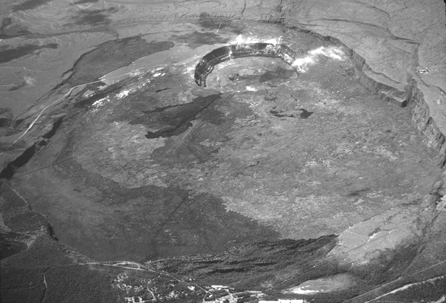 Aerial view of Kilauea Volcano summit caldera; the view is to the southwest. The caldera is 4.5 km by 3 km, and Halema‘uma‘u Crater, in the upper center, is 1 km in diameter (January 10, 1985, J.D. Griggs). |
| DATA |
|
| PLOTFILES |
|
| PHOTOGRAPHS |
LINKS |
U.S. Department of the Interior
U.S. Geological Survey
For questions about the content of this report, contact Dave Ramsey
Suggested citation and version history
Download a free copy of the latest version of Adobe Reader.
|
Help |
PDF help |
Publications main page |
| Western Data-Series reports |
| Geology | Volcano Hazards Program
|
This report is also available in printed form as USGS Geologic Investigations Series I-2759. This database is also available as USGS Data Series 293 on CD-ROM. Obtain either by writing:
USGS Information Services
Box 25286, Federal Center
Denver, CO 80225
Telephone: 1-888-ASK-USGS
E-mail: infoservices@usgs.gov

![]() U.S. Department of the Interior | U.S. Geological Survey
U.S. Department of the Interior | U.S. Geological Survey
URL: https://pubs.usgs.gov/ds/2007/293/
Page Contact Information: Michael Diggles
Page Created: November 11, 2007
Page Last Modified: October 17, 2008
(mfd)