Western Coastal and Marine Geology
|
1Coastal and Marine Geology, USGS, Pacific Science Center, Santa Cruz, CA
U.S. Department of the Interior
U.S. Geological Survey
|
||||||||
|
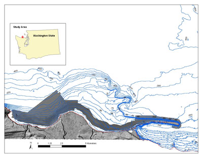
Figure 1. Location map of sea-floor mapping for the Elwha River Delta nearshore, Washington. To view a large version of Figure 1 in a new window, click on the image above. AbstractFrom March 1531, 2005, more than 252 km (19.5 km2) of seafloor offshore of the Elwha River Delta in the central Strait of Juan de Fuca was mapped by the USGS Coastal and Marine Geology Program. The purpose of this nearshore mapping was to (1) obtain high resolution bathymetry and acoustic reflectance properties of the seabed, (2) examine and record geologic characteristics of the seafloor, and (3) construct maps of sea-floor geomorphology and habitat. Substrate distribution was characterized with video-supervised statistical classification of the sonar data. Substrate of the survey was dominated by mixed sand-gravel and sand. Numerous boulder reefs were observed west of the river mouth within Freshwater Bay, whereas the sea-floor immediately adjacent to the river mouth was dominated by sand. Citation: Cochrane G.R., Warrick, J.A, Sagy, Y., Finlayson, D., Harney, J., 2008. Sea-floor mapping and benthic habitat GIS for the Elwha River
Delta nearshore, Washington. U.S. Geological Survey Data Series 320
IntroductionTwo dams on the Elwha River of Washington are planned to be removed in response to the Elwha River Ecosystem and Fisheries Restoration Act (Public Law 102-495), signed October 24, 1992 (106 Stat. 3173). The objective of dam removal is the restoration of salmon spawning runs to river reaches upstream of the dams. Dam removal will also release millions of cubic meters of sediment from the reservoir deltas to the river, and much of this sediment is expected to be transported down the river to the river mouth and Strait of Juan de Fuca (Randle and others, 1996; Childers and others, 2000). The goal of this work is to characterize and map the sea-floor substrate and habitat types near the Elwha River mouth, so that future changes may be identified. Geologic substrates of the sea floor provide benthic habitats for a number of recreationally and commercially important species, including shellfish, juvenile and adult salmon, and halibut. The U.S. Geological Survey (USGS) conducted sonar mapping offshore of the Elwha River mouth aboard the R/V Karluk during March 1531, 2005 (fig. 1). Underwater video-mapping was conducted in cooperation with the Washington Department of Fish and Wildlife (WADFW) during March 1618, 2004. To construct maps of geologic substrate and habitat distribution, sonar-derived bathymetry and acoustic amplitude data were combined with underwater video observations of geologic and biologic characteristics. Swath sonar mapping was conducted on alongshore ship-tracks to maximize continuous data coverage. The sea-floor video observations were logged real-time in the field by a team of USGS geologists and WADFW biologists. Video observations were concentrated on areas of distinct sonar character and along transitions between areas of contrasting sonar character. Final substrate and habitat maps were generated in an ESRI Geographic Information Systems database (ArcGIS) using a statistical-based classification. Lastly, an uncertainty analysis of these final products (benthic habitat distribution map) was also conducted. Revisions and UpdatesThis geographic information system (GIS) compilation may be revised and updated as new data become available, and changes will be posted online. Changes to the GIS will be described in the Revision History section. The hosting site could change. If there is no forwarding link, go the USGS home page (usgs.gov) and search for keywords "elwha benthic habitat." File and Data FormatsText files (.txt) on the web site may be viewed without special software. Hypertext mark-up language files (.html) require a browser such as Netscape Navigator or Internet Explorer. Imagery is presented as JPEG (.jpg) or TIFF (.tif) formats and may be viewed by many common image software packages. The GIS data files require ESRI ArcExplorer, ArcView, or ArcInfo. ArcExplorer is an application that ESRI licenses without charge for Windows operating systems. ArcView and ArcInfo are licensed applications that must be purchased. Please note that any use of trade, product, or firm names is for descriptive purposes only and does not imply endorsement by the U.S. Government. The data were compiled in ArcGIS (version 9.1; ESRI 2005), a commercial GIS, in the UTM Zone 10N coordinate system with datum WGS84. Raster data layers are in ArcInfo GRID format or are registered TIFF images. Point, line and polygon features are in ESRI shapefile format. Shapefiles were generated in geographic coordinates with datum WGS84. Each data layer is accompanied by Federal Geographic Data Committee (FGDC) compliant metadata and an overview map. AcknowledgmentsThe authors would like to thank Mike Boyle, Gerry Hatcher, Larry Kooker, Andy Stevenson, and Eric Grossman of the USGS for mobilization and operation of the sonar and camera systems. Hank Chezar of the USGS designs and maintains the bottom video camera systems. Jesse Stark and Katherine Peet of the NOAA piloted the R/V Karluk. Tina Rohila of WADFW assisted with species identification during the video operations. This publication benefited from technical review by Doug George and Eric Grossman of the USGS. ReferencesAnderson, T.J., Cochrane, G.R., Roberts, D.A., Chezar, H., and Hatcher, G., in press, A systematic real-time method to characterize sea-floor habitats and benthic macro-organisms; Habitat mapping with a side-scan sonar and towed camera-sled: Proceedings, Geohab Conference, Victoria, British Columbia, May 4-7, 2005. Childers, D., Kresch, D.L., Gustafson, A.S., Randle, T.J., Melena, J.T., Cluer, B., 2000, Hydrologic data collected during the 1994 Lake Mills drawdown experiment, Elwha River, Washington, Water-Resources Investigations Report 99-4215, U.S. Geological Survey 115 p. Cochrane, G.R., and Lafferty, K.D., 2002, Use of acoustic classification of sidescan sonar data for mapping benthic habitat in the Northern Channel Islands, California: Continental Shelf Research, v. 22, p. 683-690. Dragovich, J.D., Logan, R.L., Schasse, H.W, Walsh, T.J., Lingley, W.S. Jr., Norman, D.K., Gerstel, W.J., Lapen, T.J., Schuster, J.E., and Meyers, K.D., 2002, Geologic map of the Washington-Northwest Quadrant: Washington Division of Geology and Earth Resources Geologic Map GM-50. Folk, R.L. and Ward, W.C., 1957, Brazos River bar, a study in the significance of grain-size parameters: Journal of Sedimentary Petrology, v. 27, p. 3-27. Greene, G.H., Yoklavich, M.M, Starr, R.M., O'Connell, V.M., Wakefield, W.W., Sullivan, D.E., McRea, J.E., and Cailliet, G.M., 1999, A classification scheme for deep sea-floor habitats: Oceanologica Acta, v. 22, p. 663-678. Randle, T.J., Young, C.A., Melena, J.T., Ouellette, E.M., 1996, Sediment analysis and modeling of the river erosion alternative: U.S. Department of the Interior, Bureau of Reclamation, Elwha Technical Series PN-95-9, 138 p. Rubin D.M., 2004, A simple autocorrelation algorithm for determining grain size from digital images of sediment: Journal of Sedimentary Research, v. 74, no. 1, p. 160-165. Rubin, D.M., Chezar, H., Harney, J.N., Topping, D.J., Melis, T.S., Sherwood, C.R., 2006, Underwater microscope for measuring spatial and temporal changes in bed-sediment grain size: U.S. Geological Survey Open-File Report 2006-1360. U.S. Geological Survey, 2005, Coastal and Marine Geology InfoBank: [http://walrus.wr.usgs.gov/infobank/s/s105sc/html/s-1-05-sc.meta.html]. For more information, contactGuy R. Cochrane |
Project Description
|
|||||||
|
||||||||
| Help
| PDF help
| Western reports main page | Western Data Series publications |
| Geologic
Division | Western Coastal and Marine Geology
|
This report is available only on the Web.

![]() U.S. Department of the Interior | U.S. Geological Survey
U.S. Department of the Interior | U.S. Geological Survey
URL: https://pubs.usgs.gov/ds/320/
Page Contact Information: Michael Diggles
Page Last Modified: May 7, 2008 (mfd)