Data Series 321
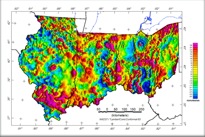 
This web site gives the results of a USGS project to acquire the best available, public-domain, aeromagnetic and gravity data in the United States and merge these data into uniform, composite grids for each state. The results for the three states, Illinois, Indiana, and Ohio are presented here in one site. Files of aeromagnetic and gravity grids and images are available for these states for downloading. In Illinois, Indiana, and Ohio, 19 magnetic surveys have been knit together to form a single digital grid and map. And, a complete Bouguer gravity anomaly grid and map was generated from 128,227 gravity station measurements in and adjacent to Illinois, Indiana, and Ohio. In addition, a map shows the location of the aeromagnetic surveys, color-coded to the survey flight-line spacing. This project was supported by the Mineral Resource Program of the USGS. Any use of trade, product, or firm names is for descriptive purposes only and does not imply endorsement by the U.S. Government. |
Version 1.0 Posted March 2008 |
Daniels, D.L., Kucks, R.P., and Hill, P.L., 2008, Illinois, Indiana, and Ohio magnetic and gravity maps and data—A website for distribution of data: U.S. Geological Survey Data Series 321.

![]() U.S. Department of the Interior | U.S. Geological Survey
U.S. Department of the Interior | U.S. Geological Survey
URL: http://pubsdata.usgs.gov/pubs/ds/321/index.html
Questions or Assistance: Contact USGS
Last modified: Monday, 28-Nov-2016 12:48:37 EST
