 |
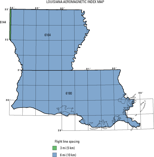 |
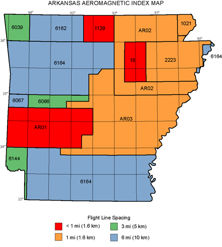
Table 1. Arkansas and Louisiana aeromagnetic compilation index.
Survey no.1 |
Survey
type2 |
Survey name3 |
Flown by4 |
Date
flown |
Spacing5
(mi) |
Direction5 |
Altitude6
(ft) |
Datum7 |
Publication8 |
16 |
M–Dz |
Newport |
U.S. Geological
Survey |
04/50–05/50 |
0.25–
0.5 |
N–S |
1,000 AG |
Total field,
arbitrary datum |
GP–370, Jesperson, 1964 |
1021 |
M–Dz |
New Madrid '73 |
U.S. Geological
Survey |
05/73–06/73 |
1 |
E–W |
1,000 B |
Total field,
arbitrary datum |
OFR 74-360, U.S. Geological Survey, 1974 |
1129 |
M–D |
Harrison |
U.S. Geological
Survey |
04/87–05/87 |
0.46 |
N–S |
500 AG |
DIGRF |
MF–1994–B, McCafferty and others, 1989 |
2223 |
M–Dzg |
New Madrid '75
(Jonesboro) |
U.S. Geological Survey |
02/75–03/75 |
1 |
E–W |
1,000 B |
Total field,
arbitrary datum |
OFR 76–318, U.S. Geological Survey,1976 |
6039 |
M/R–D |
Central Lowlands
(Tulsa) |
Texas Instruments,
Inc. |
07/77–10/77 |
3 |
E–W |
400 AG |
IGRF? |
GJBX–100(78), Texas Instruments,
1978 |
6066 |
M/R–D |
Little Rock |
GeoLife, Inc. |
02/78–03/78 |
3 |
N–S |
400 AG |
IGRF65 |
GJBX–115(79)
GeoLife, Inc., 1979a |
6067 |
M/R–D |
McAlester |
GeoLife, Inc. |
03/78 |
6 |
N–S |
400 AG |
IGRF65 |
GJBX–174(79)
GeoLife, Inc., 1979b |
6144 |
M/R–D |
Texarkana and Tyler |
EG&G GeoMetrics,
Inc. |
10/79–11/79 |
3 |
N–S,
E–W |
400 AG |
IGRF75 |
GJBX–069(80), EG&G GeoMetrics,
Inc., 1980a |
6162 |
M/R–D |
Springfield–Harrison |
EG&G GeoMetrics,
Inc. |
04/80–05/80 |
6 |
E–W |
400 AG |
IGRF75 |
GJBX–150(80), EG&G GeoMetrics,
Inc., 1980b |
6164 |
M/R–D |
South-central United
States (Alexandria,
Blytheville, El Dorado,
Fort Smith, Greenwood, Jackson,
Nachez, Russellville, Shreveport) |
EG&G GeoMetrics,
Inc. |
05/80–07/80 |
6 |
E–W |
400 AG |
IGRF75 |
GJBX–151(80), EG&G GeoMetrics,
Inc., 1980h
Also by GeoMetrics, Inc.:
GJBX–152(80), 1980i
GJBX–153(80), 1980j
GJBX–180(80), 1980k
GJBX–182(80), 1980c
GJBX–183(80), 1980d
GJBX–200(80), 1980e
GJBX–204(80), 1980f
GJBX–205(80), 1980g |
6180 |
M/R–D |
Gulf Coast (Baton Rouge, Breton Sound, Lake Charles, Mobile, New Orleans, Port Arthur) |
EG&G GeoMetrics, Inc. |
08/80–09/80 |
6 |
E–W |
400 AG |
IGRF75 |
GJBX–221(80), EG&G GeoMetrics,
Inc., 1980l
Also by GeoMetrics, Inc.:
GJBX–222(80), 1980m
GJBX–223(80), 1980n
GJBX–224(80), 1980o |
AR01 |
M–Dz |
West-central Arkansas |
Aero Service Corp. |
?/67 |
0.5 |
E–W |
500 AG |
? |
Aero Services Corp., 1967 |
AR02 |
M–Dzg |
Northeast Arkansas |
Applied Geophysical Corp. |
05/77–06/77 |
1 |
E–W |
2,000 B |
IGRF75 |
OFR 79–1208,
Hendrix and Hildenbrand, 1979 |
AR03 |
M–Dg |
East-central Arkansas
(proprietary data) |
Kansas Geological Survey |
?/80 |
1 |
E–W |
1,000–
2,000 B |
IGRF75 |
OFR 81–758,
Hildenbrand, Hendrix, and Kucks, 1981 |
1Survey no.: Internal U.S. Geological Survey identification number.
2Survey type: D, digital data; Dg, digital data—grid only; Dz, digitized data, Dzg, digitized data—grid only; M, magnetics; R, radiometrics.
3Survey name: Internal project name (may not be name used in publication title).
4Flown by: Company or government agency that flew the original survey.
5Spacing and Dir: Primary flight-line spacing and primary flight-line direction.
6Altitude: Primary flight altitude. AG, above ground and draped over topography; B, barometric elevation.
7Datum: Original magnetic reference field datum used by contractor. Indicates if a regional field was removed and, if it could be determined, the base value removed. Total field, no regional field was removed; arbitrary datum, base value removed was not stated on the map. DIGRF, definitive geomagnetic reference field; IGRFxx, international geomagnetic reference field for the model year 19xx; ?, unknown.
8Publication: Brief publication reference. U.S. Geological Survey publications: GP, Geophysical Investigation Maps; MF, Miscellaneous Field Investigations Maps;
OFR yy–xxx where yy is the publication year, Open-File Reports. Other publications: AR, Arkansas State; GJBX, Department of Energy, National Uranium Resource Evaluation (NURE) reports.
|
|
Version 1.0
Posted August 2008
|

