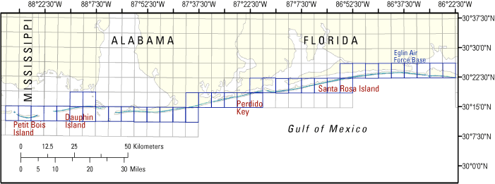
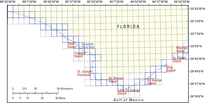
Data Series 384

LIDAR Illustration

Home

Purpose Link

Metadata Link

Collaborators Link

Acronyms Link

2008

EAARL Coastal Topography–Northern Gulf of Mexico

Amar Nayegandhi,1 John C. Brock,2 Abby Sallenger,2 C. Wayne Wright,3 Laurinda J. Travers,4 and James Lebonitte1

1Jacobs Technology, St. Petersburg, FL, 2 USGS, FISC St. Petersburg, FL, 3NASA, Wallops Flight Facility, Wallops Island, VA, 4Eckerd College, St. Petersburg, FL


This DVD contains Lidar-derived bare earth (BE) and first surface (FS) coastal topography GIS datasets of the northern Gulf of Mexico, which includes Florida, Alabama, and Mississippi, following Hurricane Ivan's landfall on September 16, 2004. These datasets were acquired on September 19, 2004.

Click on one of the Quarter-Quad areas, highlighted in blue on each map, to view the corresponding images and links to each data directory.


  • DOQQ Map of the western side of Northern Gulf of Mexico


  • DOQQ Map of eastern side of Northern Gulf of Mexico Tile 29084e8b Tile 29085h3d Tile 30085b6c Tile 30085b7b Tile 30086c1c Tile 30086d3d Tile 29085f3c Tile 29084h3c Tile 29084h4d Tile 29084h4a Tile 29084h3d Tile 29084g5d Tile 29084g5c Tile 29084g6d Tile 29084g6a Tile 29084f6c Tile 29084f7b Tile 29084f8a Tile 29084f7d Tile 29084f7a Tile 29085e1c Tile 29085e1b Tile 29084e8c Tile 29085f1d Tile 29085f2a Tile 29085f2d Tile 29085f3a Tile 29085f3d Tile 29085f4b Tile 29085g4a Tile 29085g4b Tile 29085h4a Tile 29085h4b Tile 29085h4c Tile 29085h5b Tile 30085a5d Tile 30085a5a Tile 30085a5c Tile 30085a6b Tile 30085a6c Tile 30085b7d Tile 30085b6d Tile 30085b7a Tile 30085b7c Tile 30085b8b Tile 30086c1a Tile 30086c1d Tile 30085b8c Tile 30085c8d Tile 30086c2b Tile 30086c2c Tile 30086c3b Tile 30086c3c Tile 30088c2a Tile 30087c2c Tile 30087c3b Tile 30087c3c Tile 30087c2b Tile 30087c1c Tile 30087c1b Tile 30086c8b Tile 30086c8c Tile 30086d5a Tile 30086d4d Tile 30086d4a Tile 30086d5d Tile 30086d6a Tile 30086d6d Tile 30086d8a Tile 30086d7d Tile 30086d7a Tile 30087c4d Tile 30087c4a Tile 30087c3d Tile 30087c5a Tile 30087c5d Tile 30087c6a Tile 30088c2d Tile 30088b1b Tile 30088b1c Tile 30088b2b Tile 30087b8c Tile 30087b8b Tile 30087b7c Tile 30087b6b Tile 30087b8c Tile 30087b7b Tile 30088b3c Tile 30088b3b Tile 30088b2c Tile 30088b4b Tile 30088b4c Tile 30088b5b


  • Suggested Citation: Nayegandhi, A,. Brock, J. C., Sallenger, A. H., Wright, C. W., Travers, L. J., Lebonitte, J., 2008, EAARL coastal topography–northern Gulf of Mexico: U.S. Geological Survey Data Series 384, 1 DVD ROM.

    Publications are avilable from USGS Information Services, Box 25296, Federal Center, Denver, CO 80225-0046 (telephone: 1-800-ASK-USGS; email: infoservices@usgs.gov).


    Accessibility FOIA Privacy Policies and Notices

    Take Pride in America home page USA Gov LinkU.S. Department of the Interior | U.S. Geological Survey
    URL: https://pubsdata.usgs.gov/pubs/ds/384/index.html
    Page Contact Information: Feedback
    Maintained by: Publishing Service Center
    Page Last Modified: Monday, 28-Nov-2016 13:31:12 EST