U.S. Geological Survey Data Series 488
Data Used in Analyses of Trends, and Nutrient and Suspended-Sediment Loads for Streams in the Southeastern United States, 1973–2005
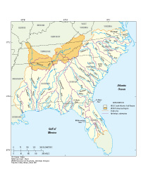
IntroductionA key objective of the U.S. Geological Survey (USGS) National Water-Quality Assessment (NAWQA) Program is to assess long-term trends in stream water quality (Gilliom and others, 2001). The stream water-quality data collected as part of the NAWQA Program and the USGS National Stream Quality Accounting Network (NASQAN) Program (Hooper and others, 1997), the Hydrologic Benchmark Network (Buell and Grams, 1985), and other USGS cooperative-study programs with State and local agencies are well suited for time-trend analysis and in-stream load estimation. Therefore, data from these combined sources were assessed for use in the analyses conducted as part of the NAWQA major river basin study in the Southeastern United States. Purpose and ScopeThe water-quality data, trend-test results, and load estimates for nutrients and suspended sediment presented in this report are for river basins draining into the Tennessee River, the southern Atlantic Ocean, and the Gulf of Mexico (fig. 1) during water years 1973–2005.1 These river basins are in the South Atlantic–Gulf and Tennessee Regions, which are Hydrologic Regions 03 and 06, respectively (Seaber and others, 1987). The data analyzed for trends are from 44 sites from the USGS National Water Information System (NWIS) database. The constituents examined include major ions, nutrients, and suspended sediment; the physical properties include pH, specific conductance, dissolved oxygen, and streamflow. The data analyzed for trends in total nitrogen and total phosphorus concentrations are from 290 sites from the U.S. Environmental Protection Agency (USEPA) Storage and Retrieval (STORET) database. In-stream nutrient and suspended-sediment loads were calculated from data collected at 48 sites from the NWIS database. The data presented in this report are in tabular formats that can be accessed and downloaded for use by environmental researchers and water managers. |

![]() U.S. Department of the Interior |
U.S. Geological Survey
U.S. Department of the Interior |
U.S. Geological Survey
URL: http://
pubsdata.usgs.gov
/pubs/ds/488/introduction.html
Page Contact Information: USGS Publications Team
Page Last Modified: Monday, 28-Nov-2016 15:11:41 EST