U.S. Geological Survey Data Series 496
1Jacobs Technology Inc., St. Petersburg, FL 33701.
2U.S. Geological Survey, St. Petersburg, FL 33701.
3Formerly Contracted with the U.S. Geological Survey, St. Petersburg, FL 33701.
4Florida Geological Survey, Tallahassee, FL 32304.
U.S. Department of the Interior
U.S. Geological Survey
Florida Integrated Science Center - St. Petersburg
Publications are available from USGS Information Services, Box 25286, Federal Center, Denver, CO 80225-0046 (telephone 1-888-ASK-USGS; e-mail: infoservices@usgs.gov).
Page Contents: |
||||
 |
||||
This DVD publication was prepared by an agency of the United States Government. Although these data have been processed successfully on a computer system at the U.S. Geological Survey, no warranty expressed or implied is made regarding the display or utility of the data on any other system, nor shall the act of distribution imply any such warranty. The U.S. Geological Survey shall not be held liable for improper or incorrect use of the data described and (or) contained herein. Reference herein to any specific commercial product, process, or service by trade name, trademark, manufacturer, or otherwise does not constitute or imply its endorsement, recommendation, or favoring by the United States Government or any agency thereof.
This disc is readable on any computing platform that has standard DVD driver software installed. The minimum software requirements are a Web browser, Adobe Reader, and a text editor. Please refer to the Details and Setup page for more information. If you cannot fully access the information on this page, please contact USGS Information Services at infoservices@usgs.gov or 1-888-ASK-USGS.
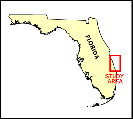
In July of 2000, the U.S. Geological Survey (USGS), in cooperation with the Florida Geological Survey (FGS), conducted a geophysical survey of the Atlantic Ocean offshore Florida's east coast from Brevard County to northern Martin County. This report serves as an archive of unprocessed digital boomer seismic reflection data, trackline maps, navigation files, Geographic Information System (GIS) information, digital and handwritten Field Activity Collection System (FACS) logs, and Federal Geographic Data Committee (FGDC) metadata. A filtered and gained (a relative increase in signal amplitude) digital image of each seismic profile is also provided. Refer to the Acronyms page for expansions of all acronyms and abbreviations used in this report.
The archived trace data are in standard Society of Exploration Geophysicists (SEG) SEG-Y format (Barry and others, 1975) and may be downloaded and processed with commercial or public domain software such as Seismic Unix (SU) (Cohen and Stockwell, 2005). Example SU processing scripts and USGS Software for viewing the SEG-Y files (Zihlman, 1992) are also provided.
The USGS St. Petersburg Coastal and Marine Science Center assigns a unique identifier to each cruise or field activity. For example, 00FGS01 tells us the data were collected in 2000 for cooperative work with the Florida Geological Survey (FGS) and the data were collected during the first field activity for that study in that calendar year. Refer to http://walrus.wr.usgs.gov/infobank/programs/html/definition/activity.html for a detailed description of the method used to assign the field activity ID.
The boomer plate is an acoustic energy source that consists of capacitors charged to a high voltage and discharged through a transducer in the water. The transducer is towed on a sled floating on the water surface and when discharged, emits a short acoustic pulse, or shot, which propagates through the water, sediment column, or rock beneath. The acoustic energy is reflected at density boundaries (such as the seafloor, sediment, or rock layers beneath the seafloor), detected by the receiver, and recorded by a PC-based seismic acquisition system. This process is repeated at timed intervals (for example, 0.5 s) and recorded for specific intervals of time (for example, 100 ms). In this way, a two-dimensional (2D) vertical profile of the shallow geologic structure beneath the ship track is produced. Figure 1 displays the acquisition geometry. Refer to table 1 for a summary of acquisition parameters.
The unprocessed seismic data are stored in SEG-Y format (Barry and others, 1975). For a detailed description of the data format, refer to the SEG-Y Format page. See the How To Download SEG-Y Data page for download instructions. The printable profiles provided are GIF images that were filtered and gained using Seismic Unix software. Refer to the Software page for details about the processing and examples of the processing scripts.
The printable profiles can be viewed from the Profiles page or from links located on the trackline maps. To view the trackline maps and navigation files, and for more information about these items, see the Navigation page. Detailed information about the navigation system used can be found in table 1.
Of a total record length of 200 ms, only the upper 100 ms of each profile are displayed because no useful information was observed deeper in the sections. A 10 ms deep water delay appears on lines b57-b63 and sl2-sl28. No digital data were collected for line sl6. However, line sl6r is a second attempt to collect digital data for this line. Digital data and 500-shot-interval location navigation are not available for the last 1,161 shots of line sl26 due to an equipment malfunction.
The Disc Contents page is a diagram of the location of all files and folders contained on this disc, it also provides links to these files and folders.
To access the information contained on this disc, use a Web browser to open the file index.html. This report is divided into seven sections: Acronyms and Abbreviations, Disc Contents, Navigation Data and Maps, Seismic Profiles, Field Activity Logs, FGDC Metadata, and Software. Links at the top and bottom of each page provide access to these sections. This report contains links to the USGS and collaborators or other resources that are only accessible if access to the Internet is available while viewing these documents.
Funding and (or) support for this study was provided by the USGS Coastal and Marine Geology Program (CMGP) and the Florida Geological Survey (FGS). We would like to thank the captain and crew of the FGS R/V Geoquest and Henry Fredenburg, formerly with the FGS, for their assistance in data collection.
Barry, K.M., Cavers, D.A., and Kneale, C.W., 1975, Recommended standards for digital tape formats: Geophysics, v. 40, no. 2, p. 344-352. Also available on-line at http://www.seg.org/publications/tech-stand.
Cohen, J.K., and Stockwell, J.W., Jr., 2005, CWP/SU: Seismic Unix Release 39: A free package for seismic research and processing: Golden, CO, Center for Wave Phenomena, Colorado School of Mines. Available on-line at http://www.cwp.mines.edu/cwpcodes/.
Zihlman, F.N., 1992, DUMPSEGY V1.0: A program to examine the contents of SEG-Y disk-image seismic data: U.S. Geological Survey Open-File Report 92-590, 28 p. Also available on-line at http://pubs.er.usgs.gov/usgspubs/ofr/ofr92590.

![]() U.S. Department of the Interior |
U.S. Geological Survey
U.S. Department of the Interior |
U.S. Geological Survey
URL: http://pubsdata.usgs.gov/pubs/ds/496/index.html
Page Contact Information: Janice A. Subino
Page Last Modified: Monday, 28-Nov-2016 15:15:12 EST
