U.S. Geological Survey Data Series 542
Grain-Size Data
Home | Acronyms | Contents | Methods | Maps | Core Data Table | Core Description Sheets | Digitized Core Logs | Grain-Size Data | Core Photographs | Field Logs | Metadata | Software
|
Note: Sample preparation, processing, and grain-size analysis procedures are described in the Methods section ("Grain-size Analysis"). Sediment samples from the 07SCC04 and 07SCC05 vibracores were analyzed using a Beckman Coulter LS 200 particle-size analyzer to measure the size distribution of sedimentary particles ranging from 0.4
1. Sample identification number. 2. Sample depth down core in feet and meters. 3. A series of columns representing the samples' cumulative weight percents between 0 and 100 percent in approximately 5-percent intervals in millimeter and phi units. 4. Each sub-samples calculated moments for: mean (Inman, 1952), standard deviation (phi units), and percent sand, silt, and clay in each sub-sample. Cruises 07SCC04 and 07SCC05:
Cruise 87039
Note: To view the grain-size data, a text editor (TXT) and (or) Microsoft Excel (XLS) is needed. Files may also be viewed online with free Google Docs, if connected to the Internet. If you are unable to open any of these files, please contact Chandra Dreher (cdreher@usgs.gov). |
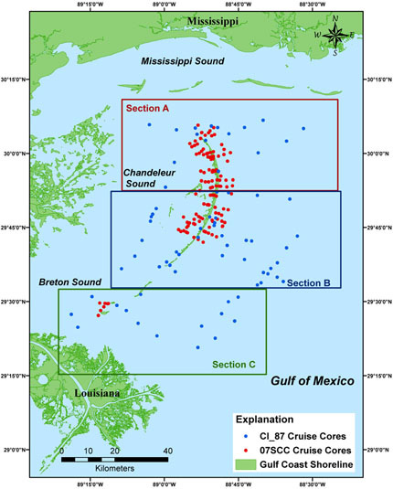
Accessing the Data To access the data for each core simply click on the Study Area Map (above) and navigate to the section that contains the desired core. Right-click (to open page in a new window) on a core or core ID label to activate the Core Data Table. The table contains a column entitled Grain-Size Data that presents thumbnail previews of individual cores and links to the downloadable XLS files. |