Data Series 543
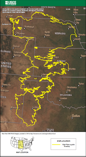
This digital data set represents the extent of the High Plains aquifer in the central United States. The extent of the High Plains aquifer covers 174,000 square miles in eight states: Colorado, Kansas, Nebraska, New Mexico, Oklahoma, South Dakota, Texas, and Wyoming. This data set represents a compilation of information from digital and paper sources and personal communication. This boundary is an update to the boundary published in U.S. Geological Survey Professional Paper 1400–B, and this report supersedes Open-File Report 99–267. The purpose of this data set is to refine and update the extent of the High Plains aquifer based on currently available information. This data set represents a compilation of arcs from a variety of sources and scales that represent the 174,000 square-mile extent of the High Plains aquifer within the eight states. Where updated information was not available, the original boundary extent defined by OFR 99–267 was retained. The citations for the sources in each State are listed in the 00README.txt file. The boundary also contains internal polygons, or "islands", that represent the areas within the aquifer boundary where the aquifer is not present due to erosion or non-deposition. The datasets that pertain to this report can be found on the U.S. Geological Survey’s NSDI (National Spatial Data Infrastructure) Node, the links are provided on the sidebar. |
First posted December 10, 2010
For additional information contact: This report is presented in Portable Document Format (PDF); the latest version of Adobe Reader or similar software is required to view it. Download the latest version of Adobe Reader, free of charge. |
Qi, S.L., 2010, Digital map of the aquifer boundary of the High Plains aquifer in parts of Colorado, Kansas, Nebraska, New Mexico, Oklahoma, South Dakota, Texas, and Wyoming: U.S. Geological Survey Data Series 543.

![]() U.S. Department of the Interior |
U.S. Geological Survey
U.S. Department of the Interior |
U.S. Geological Survey
URL: http://pubsdata.usgs.gov/pubs/ds/543/index.html
Page Contact Information: GS Pubs Web Contact
Page Last Modified: Monday, 28-Nov-2016 15:43:51 EST
