Data Series 566
![]()
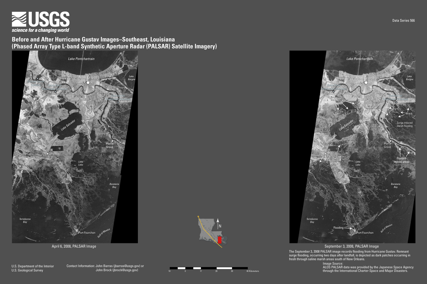
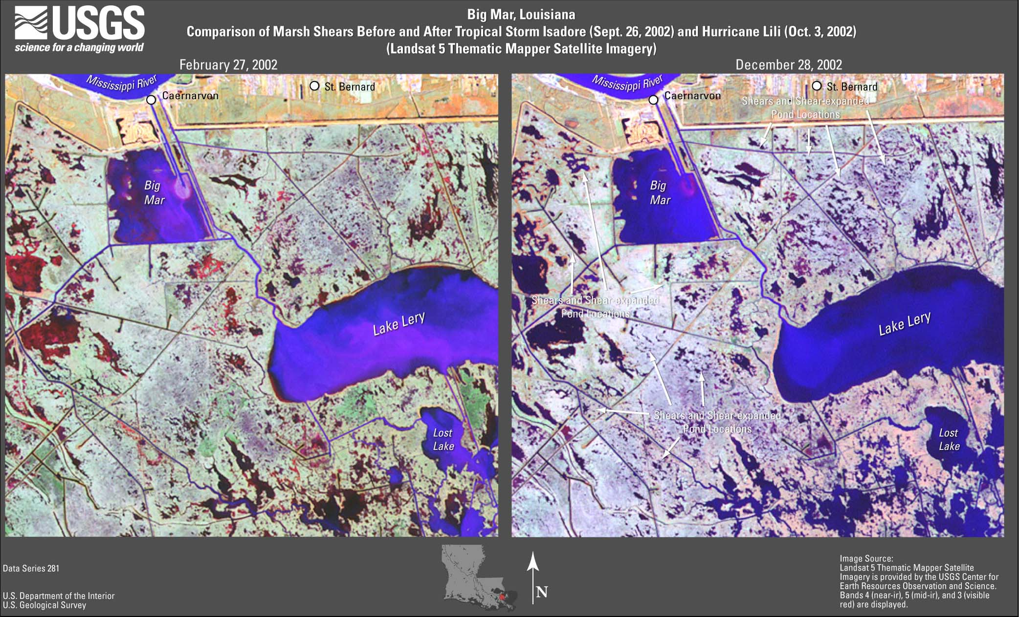
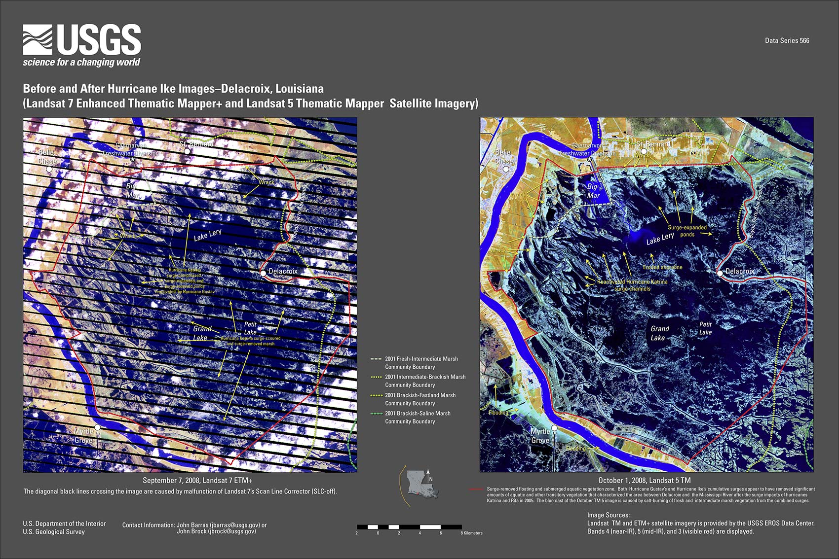
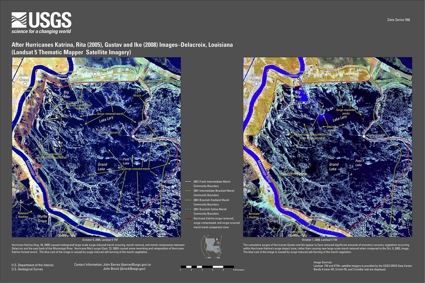
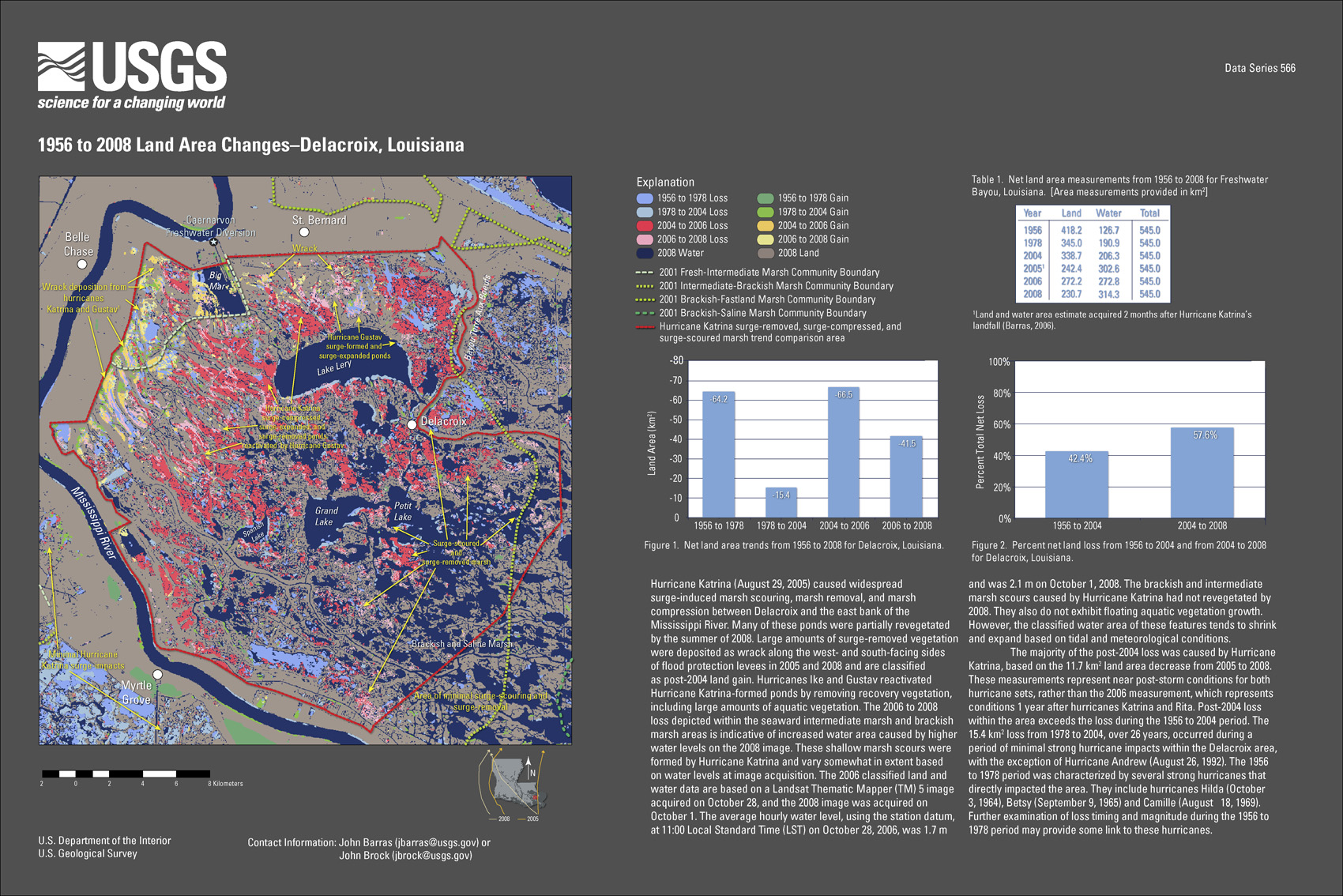
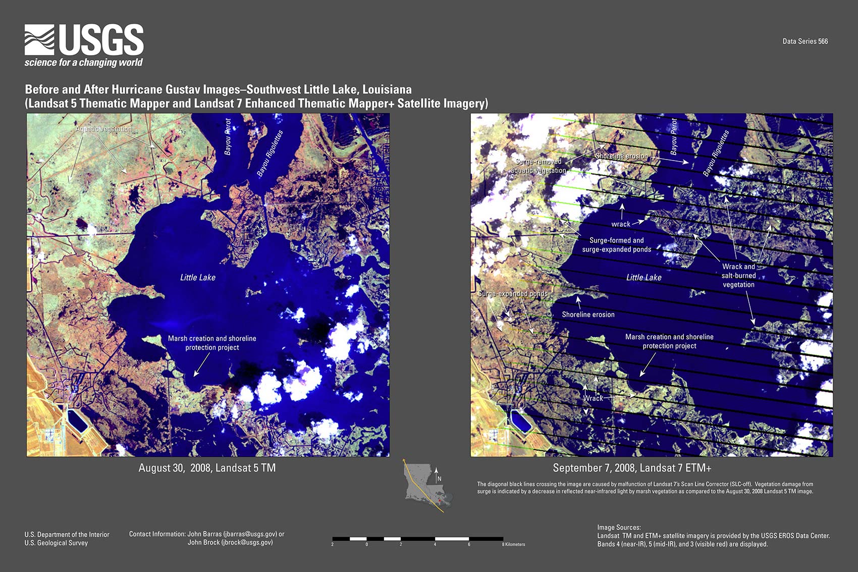
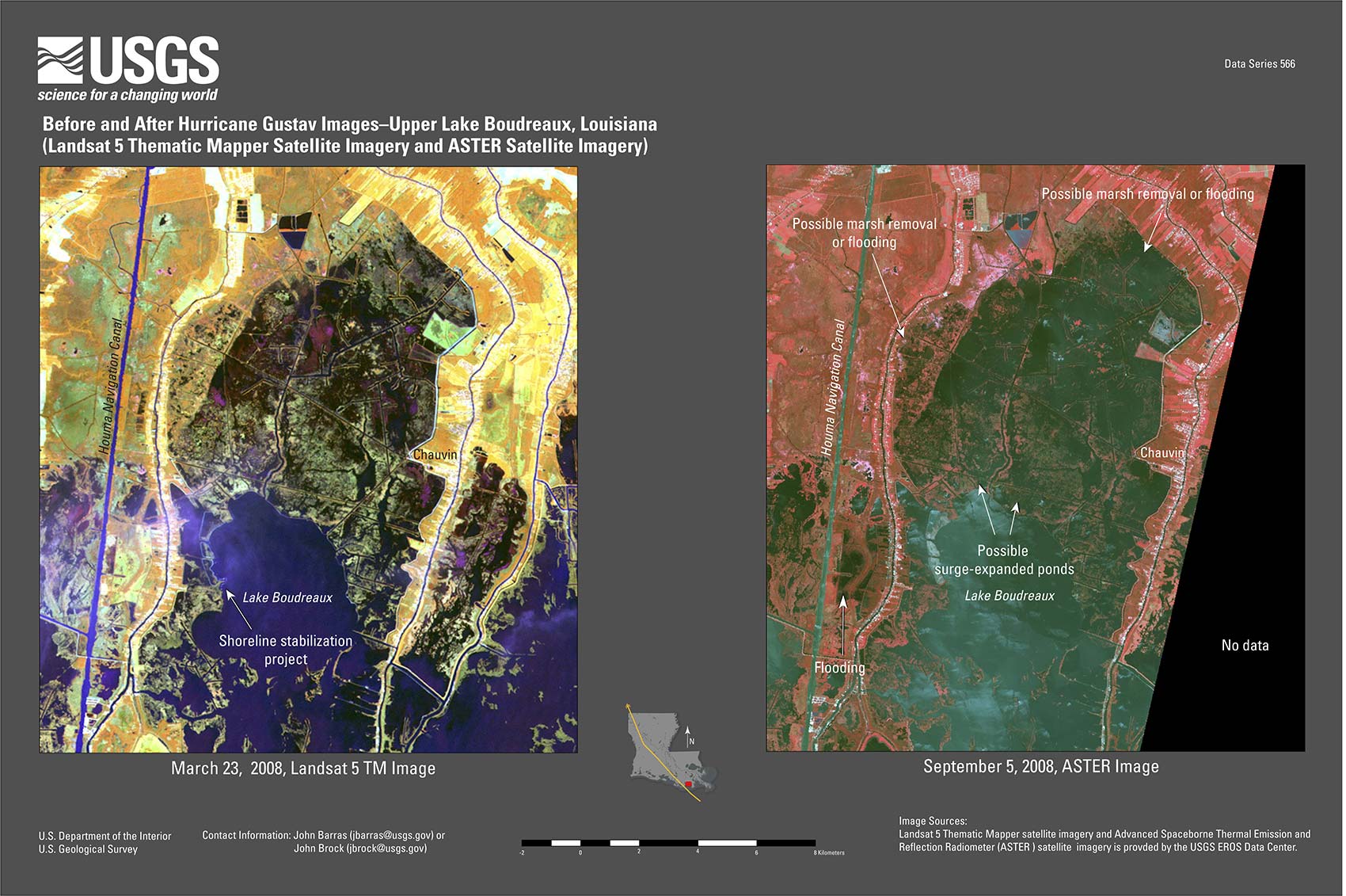
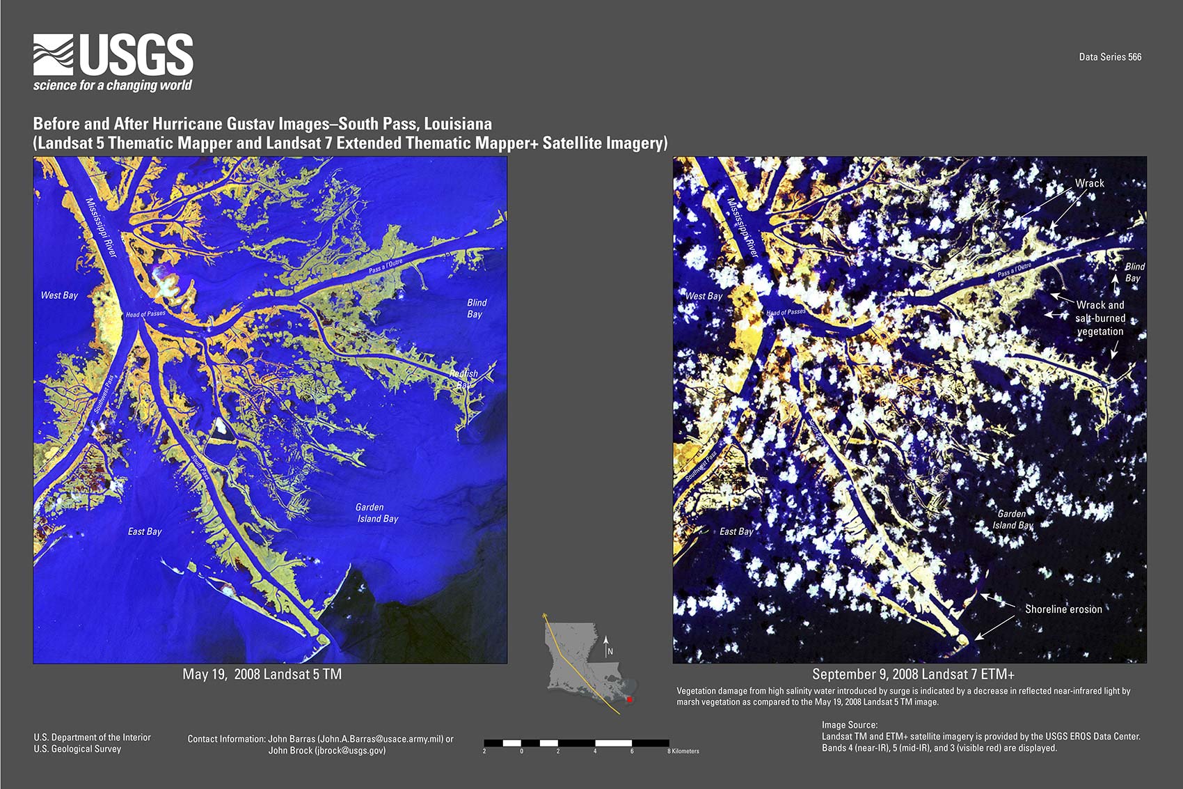
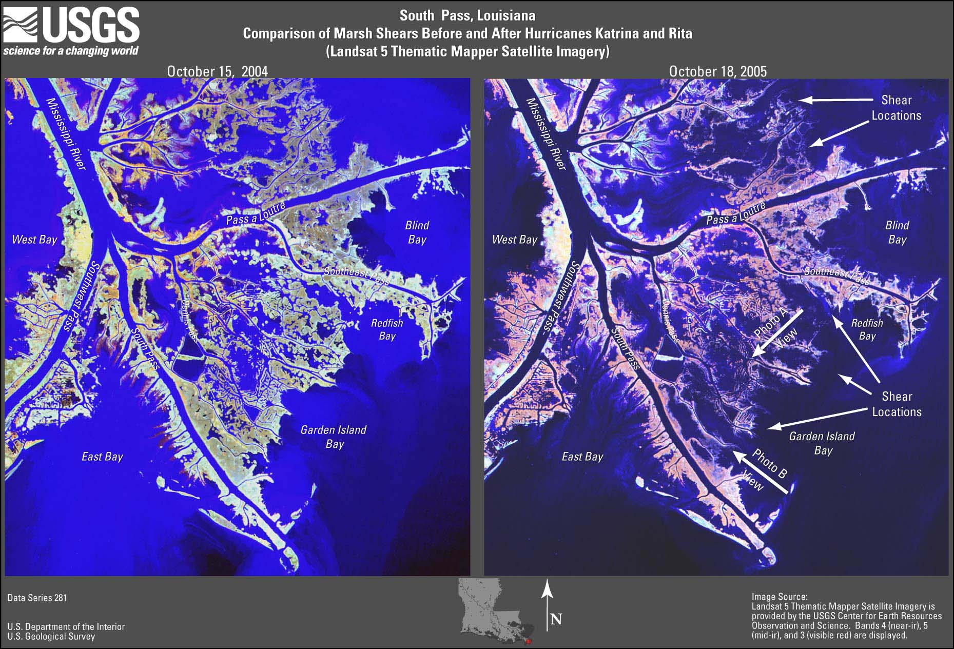
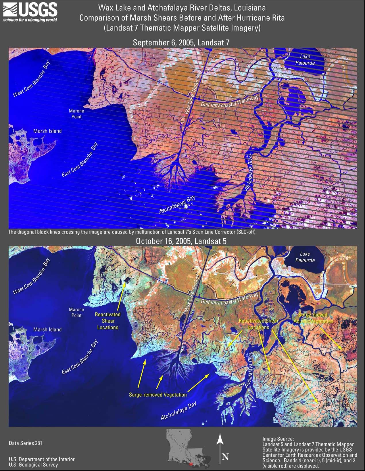
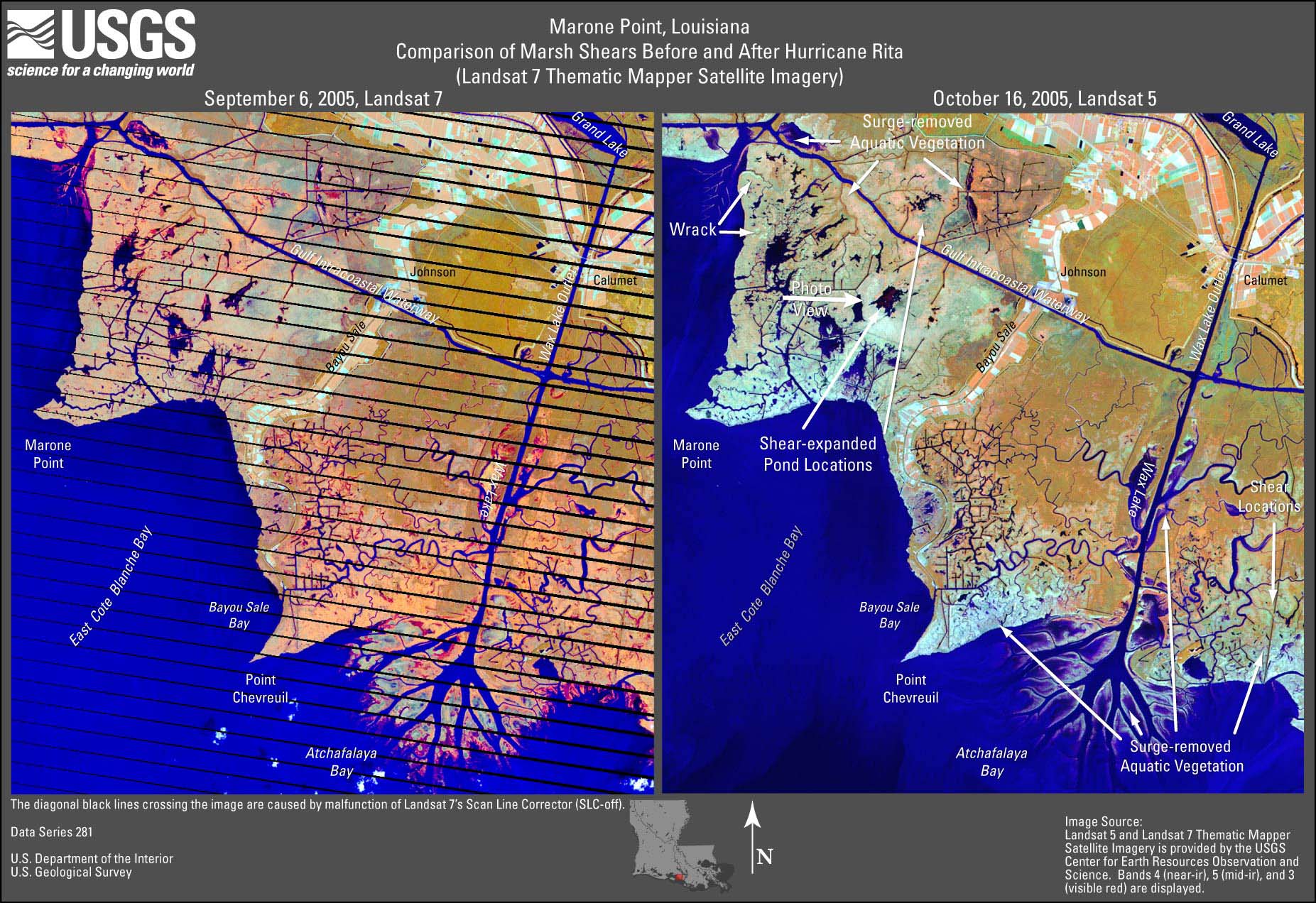
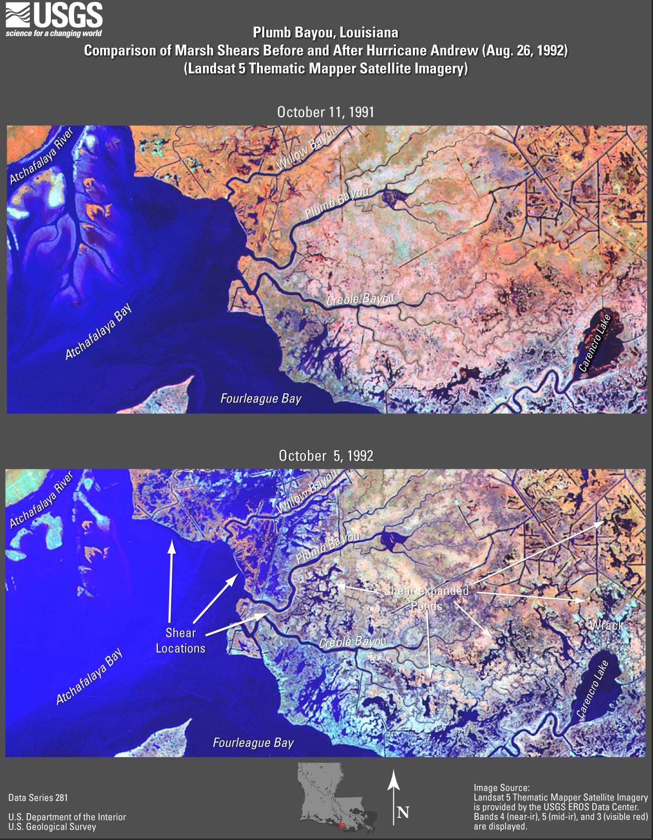
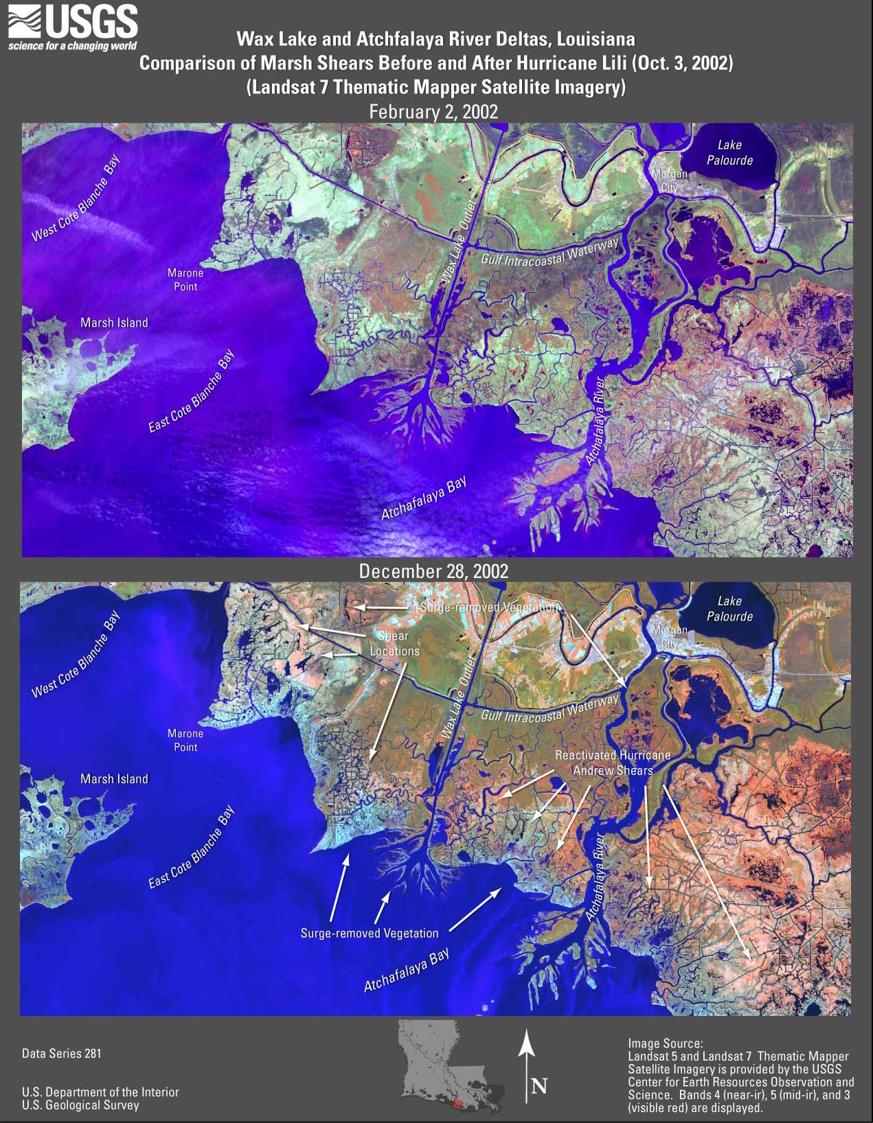
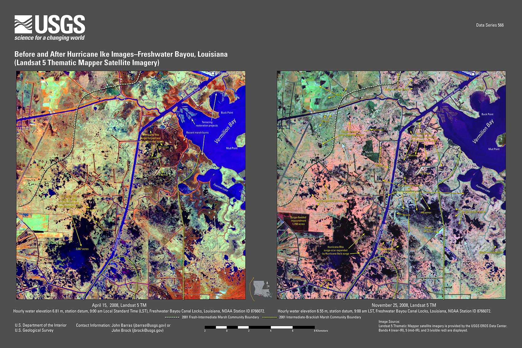
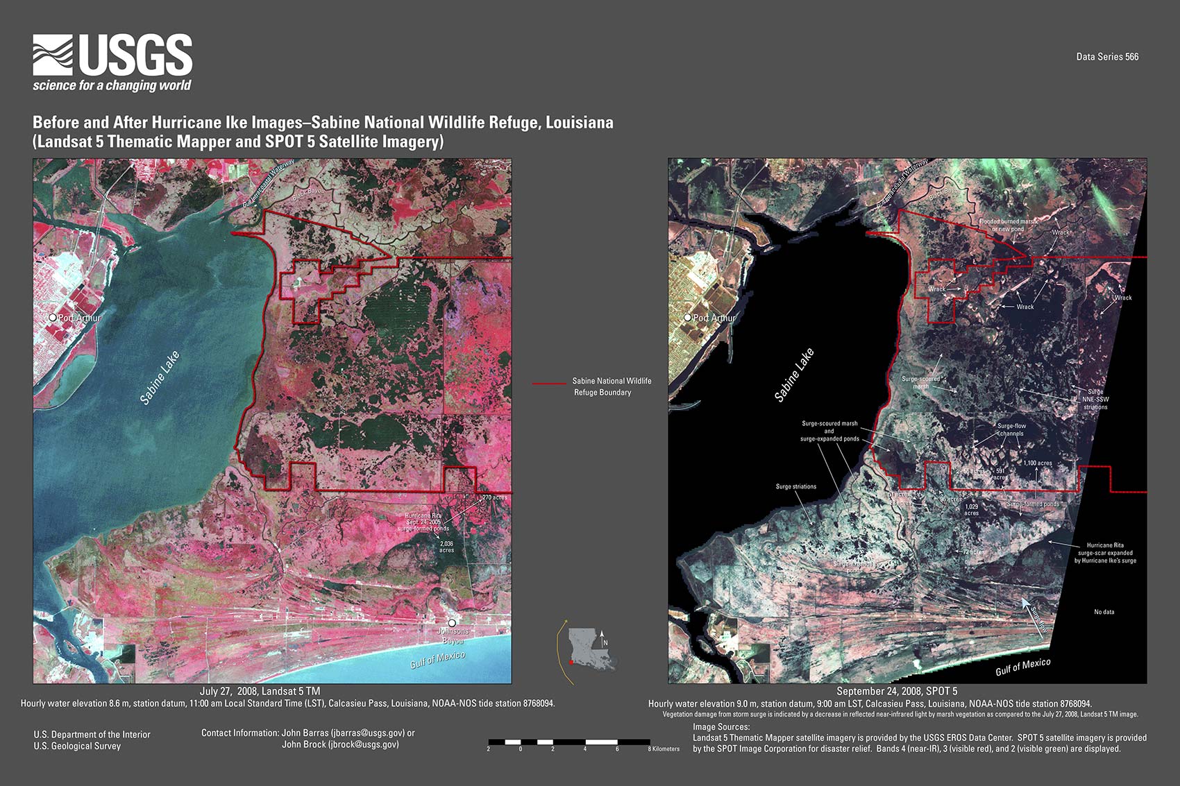
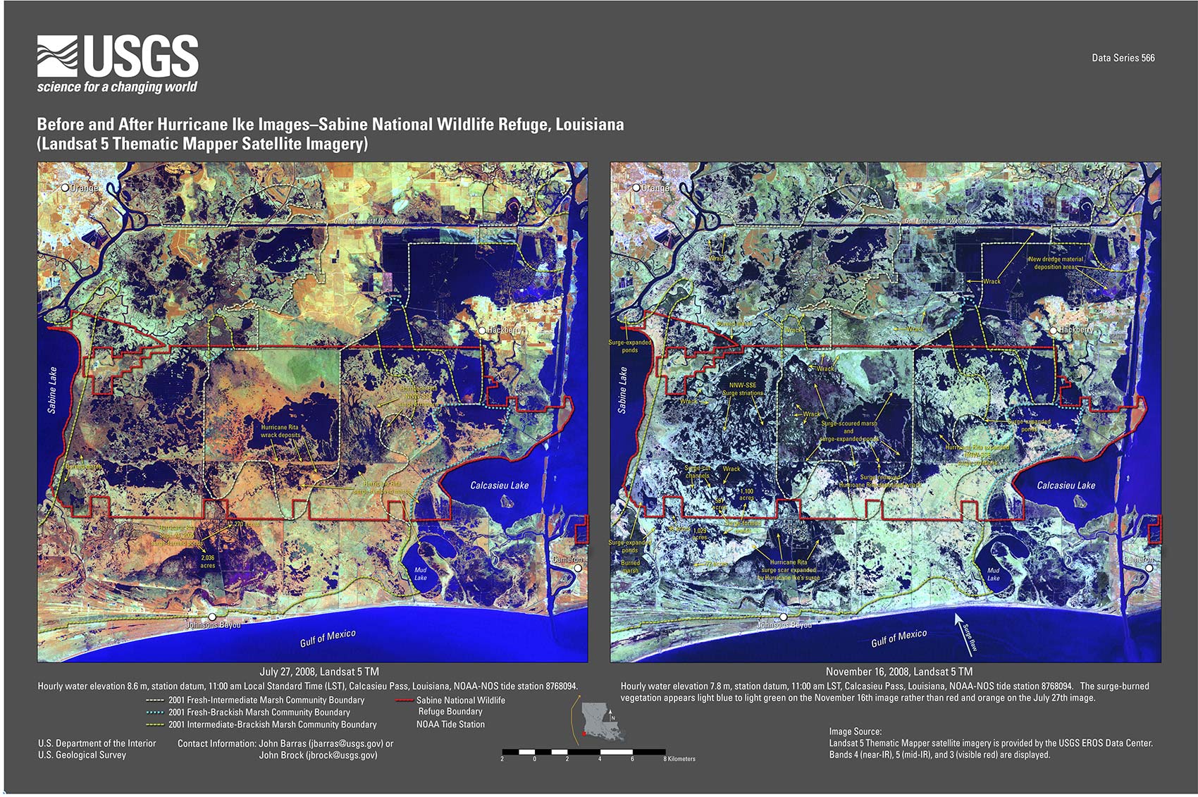
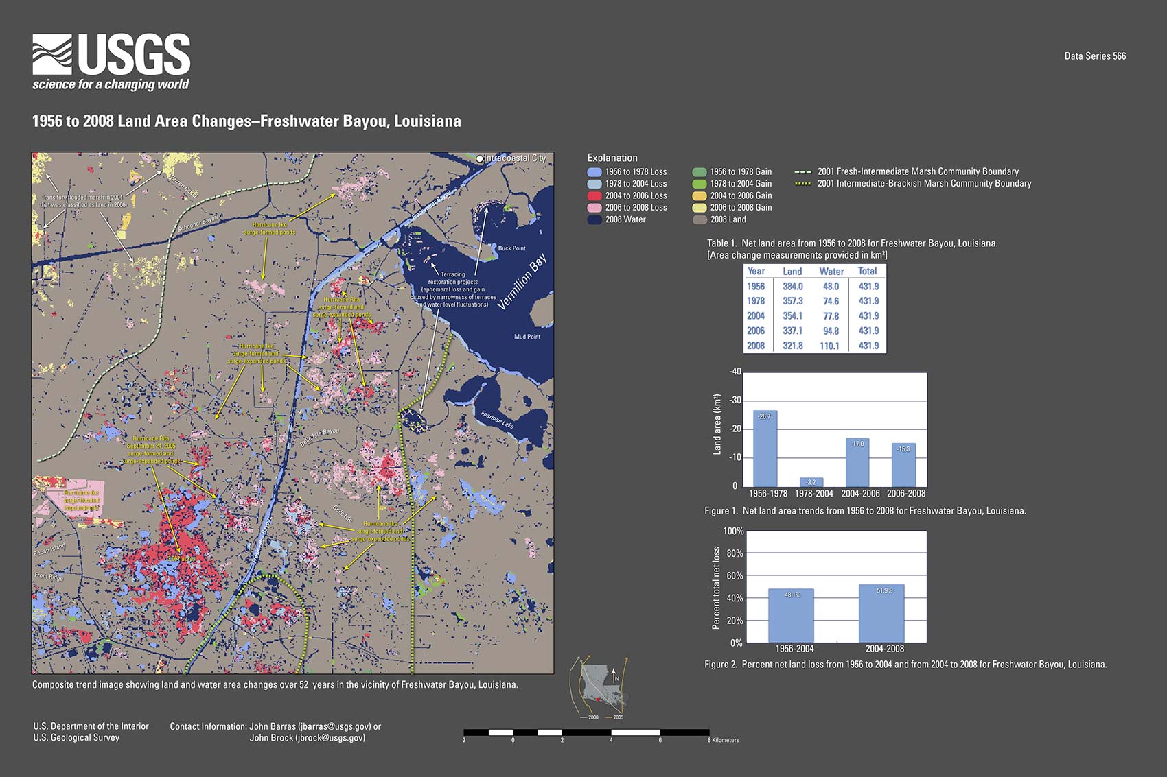
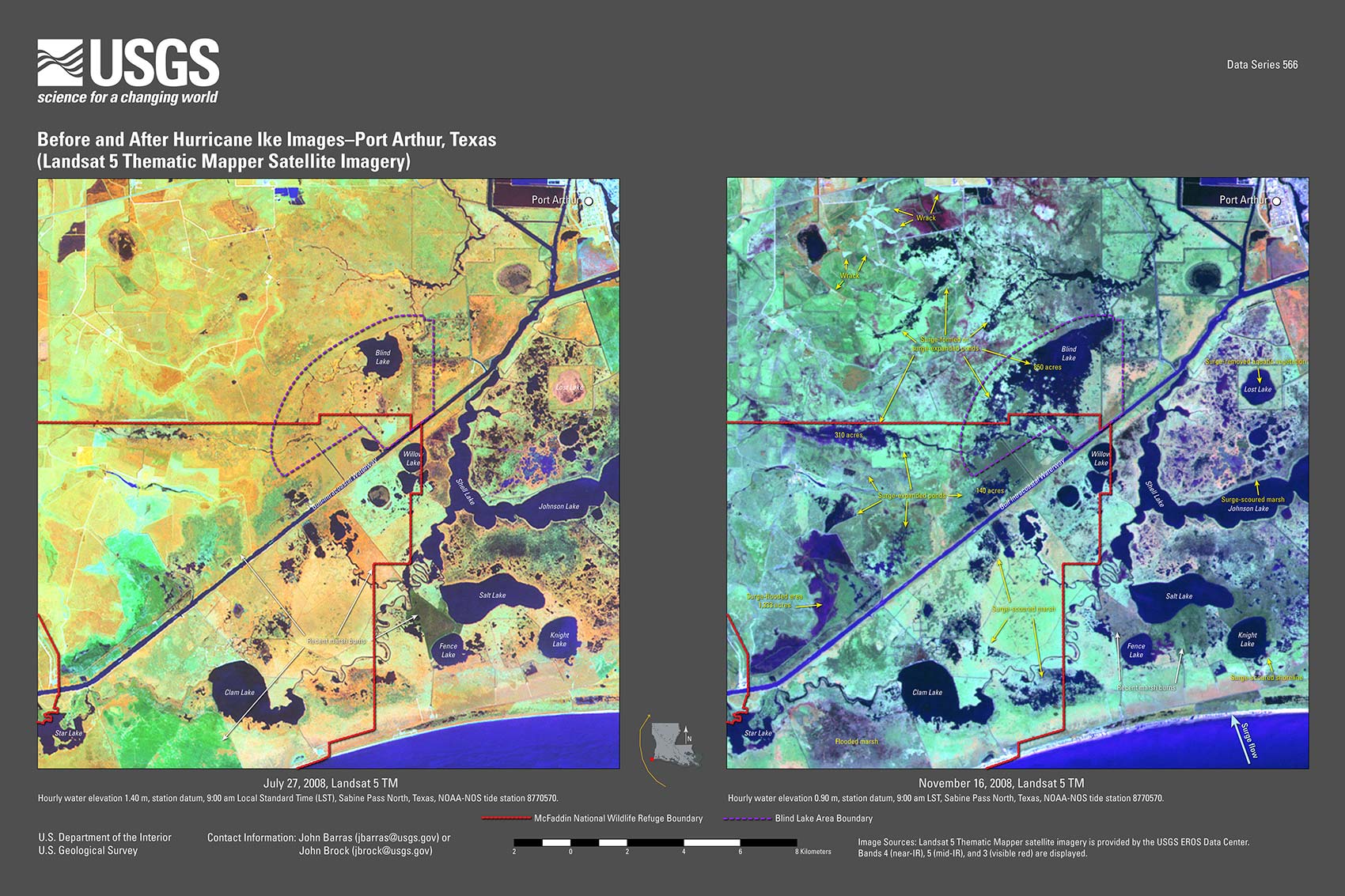
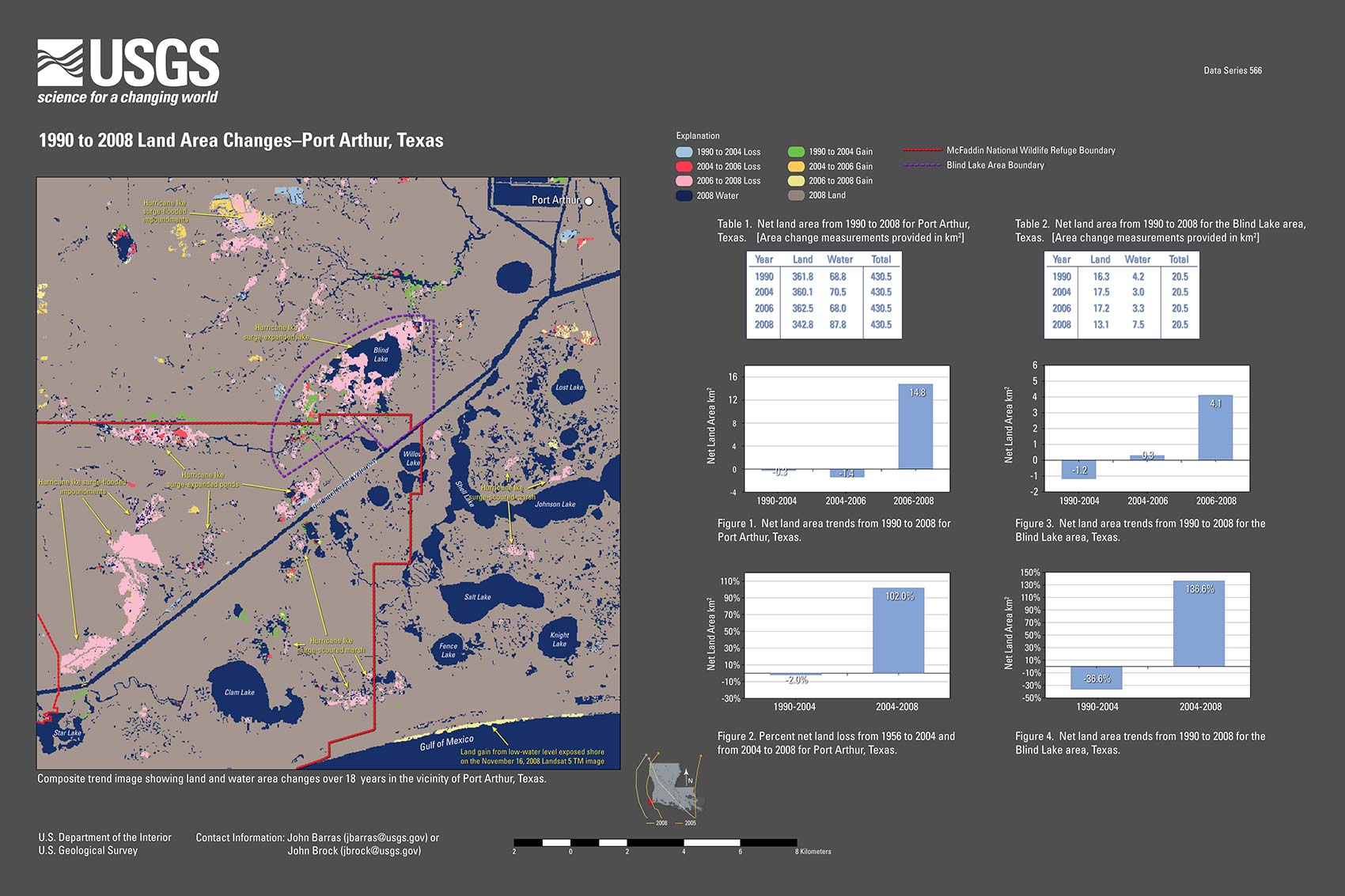
IntroductionHurricane Gustav, a category 2 storm with 170 kilometers per hour (km/h) winds, approached the Louisiana coast from the south-southeast, making landfall near Cocodrie, La., on September 1, 2008 (Beven and Kimberlain, 2009); Hurricane Ike, a category 2 storm with 175 km/h winds, approached the Texas coast from the southeast, paralleling offshore of the Louisiana coast, before making landfall along the north end of Galveston Island, Tex., on September 13, 2008 (Berg, 2009). Hurricane Ike's large wind field elevated water levels, increasing coastal flooding well before making landfall (Berg, 2009). An initial land area change assessment, based on comparison of Landsat Thematic Mapper (TM) satellite imagery, acquired before 2006 and after the 2008 landfalls of Hurricanes Gustav and Ike and classified to identify land and water, reported that the water area increased by 323 square kilometers (km2) in coastal Louisiana as a result of the storms (Barras, 2009). The land area decrease of 195 km2 was less than the 513 km2 decrease reported between 2004 and 2006 (Barras and others, 2008) after the landfalls of Hurricane Katrina, a strong category 3 storm that made landfall near Buras, La., on August 29, 2005, and Hurricane Rita, a category 3 storm that made landfall just west of Johnsons Bayou, La., on September 29, 2005. The 2004 to 2006 land area decrease is 49 km2 less than the 562 km2 initial change estimate based on satellite imagery obtained two months after the 2005 storms (Barras, 2007a). The comparison area used to identify the 2004 to 2006 land area change matches the extent of historical land and water data used to quantify coastal land loss from 1956 to 2006 (Barras and others, 2008) and is 3,841 km2 less than the 33,457.7 km2 used for Barras (2006) and Barras (2009). The greater comparison area used for the 2006 to 2008 period (Barras, 2009) resulted in a 2004 to 2006 loss estimate of 525.8 km2, 13.0 km2 greater than the 512.8 km2 estimate reported in Barras (2008). MethodologyThis report provides remotely sensed, annotated Landsat 5 TM, SPOT 5, Landsat 7 ETM+, ASTER and PALSAR imagery used in identifying surge-impacts from Hurricanes Gustav and Ike on Louisiana’s wetlands and the southeastern Texas interior coastal wetlands. An initial quantitative coastal estimate of 2006 to 2008 land area changes was provided in Barras (2009), but the report lacked site-specific examples of surge impacts. This report provides examples and images of these impacts and compares them with the impacts from hurricanes Katrina and Rita in 2005. DiscussionHurricane Gustav’s observed surge impacts, within southeastern Louisiana’s coastal wetlands, were not as great as those of Hurricane Katrina's (Barras, 2009). The earliest indications of Hurricane Gustav’s surge impacts were obtained from a September 3, 2009, Phased Array Type L-band Synthetic Aperture Radar (PALSAR) satellite image provided by the Japanese Space Agency through the International Charter Space and Major Disasters (fig. 1). The PALSAR image showed some surge-induced marsh flooding, removal of aquatic vegetation and deposition of wrack within a 144 km by 70 km swath centered on New Orleans. Advanced Spaceborne Thermal Emission and Reflection Radiometer (ASTER) satellite imagery, Landsat 5 Thematic Mapper (TM 5) satellite imagery, and Landsat 7 Enhanced Thematic Mapper Plus (ETM+ 7) satellite imagery, all provided by the U.S. Geological Survey (USGS), was then used for further storm impact assessments and to identify surge-removed and surge-scoured interior marsh from temporary marsh flooding. The 2001 marsh vegetation-salinity zones (Chabreck and others, unpub. data, 2001, Louisiana State University) were used to identify the type of marsh (saline marsh, brackish marsh, intermediate marsh or fresh marsh) where surge-impacts occurred (Barras, 2006; Barras, 2007a; Barras, 2007b) and to provide continuity of marsh community identification with the earlier studies. Hurricane Gustav’s most notable surge-impact feature was the removal of post-2005 Hurricane Katrina recovery vegetation in the fresh and intermediate marshes of the upper Breton Sound Basin (fig. 2). Several new marsh shears were observed north of Lake Lery, but there was minimal new widespread marsh removal at this location, unlike after Hurricane Katrina in 2005 (Barras, 2007a; Barras, 2007b, fig. 7A). USGS temporary water elevation gage (SSS-LA-PLA-004), deployed to monitor Hurricane Gustav's surge, recorded a maximum water level increase of 2.44 meters (m) over normal water elevation in this area (McGee and others, 2008). The September 7, 2008, Landsat 7 ETM+ satellite image was partially cloud covered, obscuring the northern portion of the image near Big Mar. The uncluttered portion of the image reveals large-scale removal of recovery vegetation in Hurricane Katrina’s surge shears northwest and west of Lake Lery (Barras, 2007b, fig. 7A). The surge-scoured intermediate marsh to the south of Lake Lery returned to its post-Hurricane Katrina appearance. The slightly reddish appearance of the marsh within the existing Hurricane Katrina surge-impact area indicates that the marsh vegetation was not yet completely senesced from surge-induced salt burning from Hurricane Gustav (fig. 2). It is likely that Hurricane Gustav would have caused more observable land loss in the upper Breton Sound Basin if Hurricane Katrina had not occurred, based on observations of prior storm-surge induced loss in this location after the landfalls of Tropical Storm Isadore (September 26, 2002) and Hurricane Lili (October 3, 2002) (Barras, 2007b, fig. 9). Hurricane Ike’s surge did not substantially alter the basin's post-Gustav appearance (fig. 3). The greatest change between the September 7, 2008 ETM+ 7 image and the October 1, 2008 TM 5 image, acquired after Hurricane Ike’s landfall, was increased senescence of marsh vegetation from surge-induced salt burning by early October. The fresh and intermediate marshes (Chabreck and others, unpublished data, 2001) had a light blue-gray appearance (fig. 3), indicating salt-stressed or senesced vegetation from having incurred two hurricane surges in less than a month, similar to how the area appeared after the 2005 hurricanes (fig. 4). The basin's appearance 17 days after hurricanes Gustav and Ike, was very similar to its fall 2005 appearance after hurricanes Katrina and Rita. The brackish-saline marsh areas appeared resistant to marsh scouring after Gustav, similar to what was observed after Hurricane Katrina in 2005 (Barras, 2006; Barras, 2007a). Land area within the Hurricane Katrina surge-impacted area (fig. 5, dashed red line) measured as 242.4 km2 in 2005, 272.2 km2 in 2006, and 230.7 km2 in 2008 (Barras and others, 2008; Barras, 2009, table 1). The land area measurements corroborate the visual interpretation of limited surge-induced loss after Hurricane Gustav in this location (fig. 4). Another noticeable feature was the deposition of an estimated 16.9 km2 of wrack in the northwest and northern portions of the basin, adjacent to Big Mar. Large amounts of light-blue wrack deposits are visible along the eastern- and southern-facing storm protection levees and along natural ridges (fig. 4). There appeared to be more wrack present in 2008 than in 2005, after hurricanes Katrina and Rita, which may be related to Gustav's surge not overtopping the storm protection levees in this area (fig. 4). Wrack deposits appear as yellow 2006 to 2008 land gain areas located outside the storm protection levee system (fig. 5).Gustav's surge also formed small marsh shears in the intermediate marsh west of Little Lake and caused shoreline erosion along the southwestern bank of Little Lake and the southeastern shoreline of Bayou Perot (fig. 6). USGS water levels for the Naomi Diversion Canal USGS streamgage 07380238, located in the eastern Barataria Basin, show the surge peaks from both hurricanes. The marsh shears formed by Hurricane Gustav were located on the western side of Barataria Basin, opposite the Naomi gage. No shears were observed in the eastern Barataria Basin, indicating Hurricane Gustav’s surge intensity was greater to the west. Areas of potential intermediate marsh removal were located north of Lake Boudreaux (fig. 7). Similar features were observed in this area after Hurricane Rita in 2005 (Barras, 2007b, fig. 14A). Shoreline erosion and barrier breaching were evident at South Pass (fig. 8). Hurricane Katrina caused much greater marsh loss in the area in 2005 (Barras, 2007b, figs. 3A, 3B, and 3C). Beach erosion was noted on the Fourchon shoreline and in the Chandeleur Islands (fig. 9). Hurricane Gustav’s surge impacts were not observed west of the Atchafalaya River, whereas Hurricane Ike’s surge impacts predominated there. Water levels recorded at USGS streamgage 07381670, located in Bayou Sale, near Franklin, La., show water elevation increases from both hurricanes. Limited regeneration of ephemeral aquatic vegetation occurred on the Wax Lake Delta, after Hurricane Rita’s removal of vegetation there in 2005 (Barras, 2007b, figs. 18A and 19A). Hurricane Ike’s surge removed flat vegetation on both the Wax Lake and Atchfalaya Deltas, returning them to an after-Hurricane Rita appearance (fig. 10). The surge also removed aquatic vegetation and caused some reshaping and enlarging of ponds in the fresh marshes surrounding both deltas. The greatest changes were observed between the east bank of the Atchafalaya River and Palmetto Bayou. Similar surge-induced changes were caused by Hurricanes Andrew (August 26, 1992), Lili, and Rita (Barras, 2007a; Barras, 2007b, figs. 16A, 16B, 16C, 17, 18A, and 18B). Moving westward, Hurricane Ike’s major surge impacts were observed 1) east of Freshwater Bayou (fig. 11) and 2) north and west of Johnsons Bayou (fig. 12). Freshwater Bayou is located 124 km east of Johnsons Bayou, which is located 130 km east-northeast of Galveston, Tex. USGS temporary water elevation gage (SSS_LA_VER-007) deployed to monitor Hurricane Ike's surge recorded a maximum water level increase of over 1.52 m above normal water elevation at Freshwater Bayou (East and others, 2008). Another gage deployed near Johnsons Bayou (SSS-LA_CAM-002) recorded a water level increase of over 2.13 m above normal water elevation (East and others, 2008). A broader view of Hurricane Ike’s surge impacts at Johnsons Bayou was provided by review of Landsat TM 5 satellite imagery, acquired on November 16, 2008 (fig. 13). The November imagery was acquired at low water levels, 2 months after Hurricane Ike’s initial surge-induced flooding. Both of these fresh and intermediate marsh locations were heavily impacted by Hurricane Rita’s surge in 2005 (Barras, 2007b, figs. 21A and 25). Ponds either formed or expanded by Hurricane Ike resembled ponds formed by Hurricane Rita in 2005. Hurricane Ike’s surge expanded existing marsh ponds previously expanded by Hurricane Rita’s surge, as well as enlarged new Rita surge-formed ponds at both locations (figs. 11, 13, 14, 15 and 16; Barras, 2007b, figs. 21 and 25). New ponds were also created by Ike’s surge in formerly contiguous marsh areas (Barras, 2009). Ponds expanded or formed by either hurricane were aligned with surge flow. Hurricane Ike’s surge-formed ponds were shifted 10 to 15 km to the west of ponds formed by Hurricane Rita (figs. 13 and 14. For example, Hurricane Rita’s surge formed a series of narrow south-by-southeast to north-by-northwest surge-cut striations, 0.5 km to 2 km in length, between Calcasieu Lake and the Sabine National Wildlife Refuge (SNWR) (Barras, 2007b, fig. 25). Hurricane Ike’s surge formed a series of similar striations located 15 km to the west, between Sabine Lake and the SNWR (figs. 13 and 14). Wrack deposition was observed in existing ponds and lakes located behind some of these new surge scours. Orientation of wrack deposits was the same as the channel striations. Johnsons Bayou’s net land area decreased by 328.8 km2 between 2004 and 2006 and between 1956 and 1978 (fig. 14). Land area remained stable from 1978 to 2004 with a small land gain of 33.6 km2. Land area decrease from 2004 to 2006 was 54.3 km2. The 2006 to 2008 decrease was 74.1 km2. Total land area decrease after 2004 was 128.4 km2, or 30.3% of the 423.6 km2 decrease reported between 2004 and 2006 (greatest of loss from 1956 to 2008 (fig. 14). Freshwater Bayou’s land area decreased by 26.7 km2 between 1956 and 1978 (fig. 15). Land area remained stable from 1978 to 2004 with a small land loss of 3.2 km2. Land area decrease from 2004 to 2006 was 17.0 km2. The 2006 to 2008 decrease was 15.3 km2. Total land area decrease after 2004 was 32.3 km2, or 51.9% of the 62.1 km2 of loss from 1956 to 2008 (fig. 15). The Texas Chenier Plain, located south-southwest of Port Arthur, incurred significant surge-induced interior marsh shearing and scouring from Hurricane Ike (fig. 16). Net land area remained stable from 1990 to 2004 with a small land gain of 0.3 km2. Land area increase from 2004 to 2006 was 1.4 km2. The 2006 to 2008 decrease was 14.8 km2. Net land area decrease between 1990 and 2008 was 13.1 km2 (fig. 17). The expansion of Blind Lake, in the Texas Chenier Plain located 10 km southwest of Port Arthur, Tex., was caused by the removal of the marsh bounding the northwestern and southeastern shorelines of the lake, expanding the lake’s area from 4.2 km2 in 1990 to to 7.5 km2 in 2008 (fig 17). In addition several other 0.4-km2 or greater ponds were created in fresh marsh, located north of the Gulf Intracoastal Waterway (GIWW) (U.S. Fish and Wildlife Service (USFW), National Wetlands Inventory (NWI), 1993). Smaller scour areas were identified in the estuarine marsh located south of the GIWW. Large areas of wrack accumulated on the southern retaining levees of agricultural fields to the north of the surge-enlarged ponds. Some surge-flooded impoundments retained water through November of 2008. A review of Landsat TM 5 imagery obtained after 2004 showed that the area sustained minimal impacts from Hurricane Rita. Land area decrease attributable to Hurricane Ike is 14.8 km2 between 2006 and 2008 (fig. 17). The 2006 to 2008 land gain along the gulf shoreline is caused by beach exposure during lower water conditions on the November 16, 2008 TM image (fig. 17). The average hourly water level recorded by the National Ocean Service (NOS) Sabine Pass North, Tex. tide station (NOS ID# 8770570), using the station datum, at 9:00 AM standard time was 1.40 m on July 27, 2008 and 0.90 m on November 16, 2008. The TM imagery was acquired at approximately 9:30 am. The water level difference between the images was 0.39 m. ConclusionThe purpose of this study was to provide preliminary observations of post-2008 hurricane land changes in coastal Louisiana using remotely sensed imagery. These observations were compared with similar observations acquired after the 2005 hurricanes. These observations will serve as a regional baseline for monitoring post-hurricane wetland recovery and for comparison of marsh conditions after future storm events at landscape scales. These new water areas, caused by the direct removal of wetlands, not only represent land losses but also indicate transitory changes caused by several factors including:
1. remnant flooding, To permanently account for these land losses, several growing seasons will have to pass for the transitory impacts of the hurricanes to be minimized. Some of the larger areas of surge-removed or surge-scoured marsh appear over multiple post-event images, some of which were acquired at low water levels following post-frontal events having north winds greater than 10 knots, indicating that some of these surge-formed features may be permanent. Similar surge-formed ponds were observed in comparable locations dating back to Hurricane Andrew in 1992. These features were often congruent in time and space, indicating that hurricanes may be an important factor in the creation and evolution of interior marsh ponds. The images are provided in both low-resolution Joint Photographic Experts Group (JPEG) format for efficiency in web viewing and in high-resolution Portable Document Format (PDF) for downloading and printing. References Cited: Barras, J.A., 2006, Land area change in coastal Louisiana after the 2005 hurricanes—a series of three maps: U.S. Geological Survey Open-File Report 2006-1274, 3 p., accesssed August 23, 2010 at, https://pubs.usgs.gov/of/2006/1274/. Barras, J.A., 2007a, Land area changes in coastal Louisiana after Hurricanes Katrina and Rita, in Farris, G.S., Smith, G.J., Crane, M.P., Demas, C.R., Robbins, L.L., and Lavoie, D.L., eds., Science and the storms—the USGS response to the hurricanes of 2005: U.S. Geological Survey Circular 1306., p. 98-113. (Also available at: https://pubs.usgs.gov/circ/1306.) Barras, J.A., 2007b, Satellite images and aerial photographs of the effects of Hurricanes Katrina and Rita on coastal Louisiana: U.S. Geological Survey Data Series 281, accesssed August 23, 2010 at, https://pubs.usgs.gov/ds/2007/281. Barras, J.A., Bernier, J.C., and Morton, R.A., 2008, Land area change in coastal Louisiana—A multidecadal perspective (from 1956 to 2006): U.S. Geological Survey Scientific Investigations Map 3019, scale 1:250,000, 14 p. pamphlet, accesssed August 23, 2010 at, https://pubs.usgs.gov/sim/3019. Barras, J.A., 2009, Land area change and overview of major hurricane impacts in coastal Louisiana, 2004-08: U.S. Geological Survey Scientific Investigations Map 3080, scale 1:250,000, 6 p. pamphlet, accesssed August 23, 2010 at, https://pubs.usgs.gov/sim/3080/. Beven, J.L. II, Kimberlain, T.B. 2009, Tropical cyclone report Hurricane Gustav 25 August-4 September 2008. National Hurricane Center, Miami, FL, accesssed August 23, 2010 at, http://www.nhc.noaa.gov/2008atlan.shtml. Berg, R., 2009, Tropical Cyclone Report Hurricane Ike 1-14 September 2008. National Hurricane Center, Miami, FL, accesssed August 23, 2010 at, http://www.nhc.noaa.gov/2008atlan.shtml. East, J.W., Turco, M.J., and Mason, R.R., Jr., 2008, Monitoring inland storm surge and flooding from Hurricane Ike in Texas and Louisiana, September 2008: U.S. Geological Survey Open-File Report 2008–1365, accesssed August 23, 2010 at, https://pubs.usgs.gov/of/2008/1365/. McGee, B.D., Goree, B.B., Tollett, R.W., and Mason, R.R., Jr., 2008, Monitoring inland storm surge and flooding from Hurricane Gustav in Louisiana, September 2008: U.S. Geological Survey Open-File Report 2008–1373, accesssed August 23, 2010 at, https://pubs.usgs.gov/of/2008/1373/. U.S. Fish and Wildlife Service (USFW), National Wetlands Inventory (NWI), 1993 FGDC_METADATA (Also available at: http://www.fws.gov/wetlands/data/metadata/conus_wet_poly_metadata.htm.) Suggested Citation: |

![]() U.S. Department of the Interior |
U.S. Geological Survey
U.S. Department of the Interior |
U.S. Geological Survey
URL: http://pubsdata.usgs.gov/pubs/ds/566/index.html
Page Contact Information: Contact USGS
Page Last Modified: Monday, 28-Nov-2016 15:48:59 EST
