Data Series 597
1U.S. Geological Survey, Fort Collins Science Center, Fort Collins, Colo.
2U.S. Geological Survey, Rocky Mountain Geographic Science Center, Denver, Colo.
3U.S. Geological Survey, Core Science Systems, Denver, Colo.
4U.S. Geological Survey, Colorado Water Science Center, Grand Junction, Colo.
5U.S. Geological Survey, New Mexico Water Science Center, Albuquerque, N.M.
6U.S. Geological Survey, Central Energy Resources Science Center, Denver, Colo.
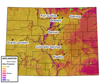
AbstractThe Colorado wind-turbine data series provides geospatial data for all wind turbines established within the State as of August 2009. Attributes specific to each turbine include: turbine location, manufacturer and model, rotor diameter, hub height, rotor height, potential megawatt output, land ownership, and county. Wind energy facility data for each turbine include: facility name, facility power capacity, number of turbines associated with each facility to date, facility developer, facility ownership, year the facility went online, and development status of wind facility. Turbine locations were derived from August 2009 1-meter true-color aerial photographs produced by the National Agriculture Imagery Program; the photographs have a positional accuracy of about ±5 meters. The location of turbines under construction during August 2009 likely will be less accurate than the location of existing turbines. This data series contributes to an Online Interactive Energy Atlas currently (2011) in development by the U.S. Geological Survey. The Energy Atlas will synthesize data on existing and potential energy development in Colorado and New Mexico and will include additional natural resource data layers. This information may be used by decisionmakers to evaluate and compare the potential benefits and tradeoffs associated with different energy development strategies or scenarios. Interactive maps, downloadable data layers, comprehensive metadata, and decision-support tools will be included in the Energy Atlas. The format of the Energy Atlas will facilitate the integration of information about energy with key terrestrial and aquatic resources for evaluating resource values and minimizing risks from energy development. |
First posted May 11, 2010
For additional information contact: |
Carr, N.B., Diffendorfer, J.E., Fancher, T.S., Latysh, N.E., Leib, K.J., Matherne, Anne-Marie, and Turner, Christine, 2011, Locations and attributes of wind turbines in Colorado, 2009: U.S. Geological Survey Data Series 597.

![]() U.S. Department of the Interior |
U.S. Geological Survey
U.S. Department of the Interior |
U.S. Geological Survey
URL: http://pubsdata.usgs.gov/pubs/ds/597/index.html
Page Contact Information: GS Pubs Web Contact
Page Last Modified: Monday, 28-Nov-2016 16:54:24 EST
