U.S. Geological Survey Data Series 652
1Jacobs Technology, Inc., St. Petersburg, FL 33701.
2U.S. Geological Survey, St. Petersburg, FL 33701.
U.S. Department of the Interior
U.S. Geological Survey
St. Petersburg Coastal and Marine Science Center
Publications are available from USGS Information Services, Box 25286, Federal Center, Denver, CO 80225-0046 (telephone 1-888-ASK-USGS; e-mail: infoservices@usgs.gov).
Table of Contents:Information StatementSystem RequirementsProject SummaryDisc OrganizationGetting StartedAcknowledgmentsReferences CitedSuggested Citation |
|||
 |
|||
This Digital Versatile Disc (DVD) publication was prepared by an agency of the United States Government. Although these data have been processed successfully on a computer system at the U.S. Geological Survey, no warranty expressed or implied is made regarding the display or utility of the data on any other system, nor shall the act of distribution imply any such warranty. The U.S. Geological Survey shall not be held liable for improper or incorrect use of the data described and (or) contained herein. Reference herein to any specific commercial product, process, or service by trade name, trademark, manufacturer, or otherwise does not constitute or imply its endorsement, recommendation, or favoring by the United States Government or any agency thereof.
This disc is readable on any computing platform that has standard DVD driver software installed. The minimum software requirements are a Web browser, a Portable Document Format (PDF) reader, and a text editor. If you cannot fully access the information on this page, please contact USGS Information Services at infoservices@usgs.gov or 1-888-ASK-USGS. NOTE: The only supported Web browsers that properly display all features of the geospatial profiles are Internet Explorer 8 for Windows and Firefox 3.6 for all platforms
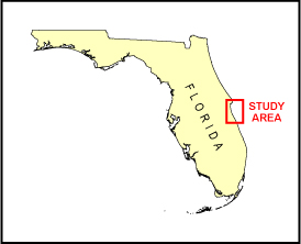
In November of 1996 and May of 1997, the U.S. Geological Survey (USGS), in cooperation with the Florida Geological Survey (FGS), conducted geophysical surveys of the shallow geologic framework of the continental shelf offshore east-central Florida from Cape Canaveral to Sebastian Inlet. This report serves as an archive of unprocessed digital boomer seismic reflection data, navigation files, trackline maps, Geographic Information Systems (GIS) files, Field Activity Collection System (FACS) logs, observer's logs, and Federal Geographic Data Committee (FGDC) metadata. Filtered and gained digital images of the seismic profiles are also provided. Refer to the Acronyms page for expansion of acronyms and abbreviations used in this report.
The USGS St. Petersburg Coastal and Marine Science Center (SPCMSC) assigns a unique identifier to each cruise or field activity. For example, 96FGS01 tells us the data were collected in 1996 for the FGS cooperative agreement and the data were collected during the first field activity for that project in that calendar year. Refer to http://walrus.wr.usgs.gov/infobank/programs/html/definition/activity.html for a detailed description of the method used to assign the cruise ID. No specific naming convention was used when naming tracklines during 96FGS01 or 97FGS01.
The boomer plate is an acoustic energy source that consists of capacitors charged to a high voltage and discharged through a transducer in the water. The transducer is towed on a sled floating on the water surface and when discharged emits a short acoustic pulse, or shot, which propagates through the water, sediment column, or rock beneath. The acoustic energy is reflected at density boundaries (such as the seafloor or sediment layers beneath the seafloor), detected by the hydrophone receivers, and recorded for specific intervals of time (for example, 100 milliseconds (ms)). In this way, a two-dimensional (2-D) vertical profile of the shallow geologic structure beneath the ship track is produced. Figure 1 displays the acquisition geometry used during this survey.
Refer to table 1 for a summary of acquisition parameters. Table 2A lists trackline statistics for 96FGS01, and table 2B lists trackline statistics for 97FGS01. Table 3 is a trackline coverage index for 97FGS01. Note: There is no trackline coverage index for 96FGS01 because all 96FGS01 lines appear on Area A map.
The unprocessed seismic data are stored in SEG Y format (rev 0) (Barry and others, 1975) and may be downloaded and processed with commercial or public domain software such as Seismic Unix (SU) (Cohen and Stockwell, 2005). For a detailed description of the data format, refer to the SEG Y Format page. See the How To Download SEG Y Data page for download instructions. The printable profiles provided here are GIF images that were filtered and gained using SU software. Example SU processing scripts and USGS Software for viewing the SEG Y files (Zihlman, 1992) are also provided. The processed SEG Y data were then exported to Chesapeake Technology, Inc. (CTI) SonarWeb software to produce a geospatial Web page of the profile, which allows the user to obtain a geographic location and depth for a cursor position on the profile. This information is displayed in the status bar of the browser.
| NOTE: The geospatial features of the geospatial profiles are only fully functional when using Internet Explorer 8 or Firefox 3.6. If using IE8, Active Content/Active X controls must be disabled. Please refer to the details and setup page for more information.
For both browsers, the status bar and JavaScript must be enabled. Firefox also requires "Change status bar text" to be checked under Advanced JavaScript Settings. This option can be found on the main Toolbar under Tools -> Options -> Content (tab) -> Advanced... -> Allow scripts to:
Use of other browsers may result in spurious or no information given in the status window. |
Boomer data for 96FGS01 were collected in standard SEG Y format with the exception of lines sb_b6a and sb_b20a, which were collected in non-standard ELICS format and later converted to SEG Y format and renamed sb6a_sgy and sb20a_sy. All 97FGS01 boomer data were collected in ELICS format and later converted to SEG Y format. The trace files for some of the lines were divided into two trace files each (for example, sb_b2 became sb_b2a and sb_b2b) because the original total number of traces exceeded the maximum allowed by the processing software.
The following lines were affected for 96FGS01:
sb_b2 |
sb_b8 |
sb_b12 |
sb_b18 |
sb_b4 |
sb_b10 |
sb_b14 |
sb_b22 |
The following lines were affected for 97FGS01:
sb_a1 |
sb_b11 |
sb_b26 |
sb_b37 |
sb_b52 |
sb_b70 |
sb_a5 |
sb_b12r |
sb_b27 |
sb_b38 |
sb_b54 |
sb_b72 |
sb_b2sn |
sb_b13 |
sb_b28 |
sb_b41 |
sb_b56 |
sb_b74 |
sb_b3 |
sb_b15 |
sb_b29 |
sb_b42 |
sb_b58 |
sb_b76 |
sb_b3sn |
sb_b17 |
sb_b31 |
sb_b43 |
sb_b60 |
sb_b78 |
sb_b5 |
sb_b21 |
sb_b32 |
sb_b45 |
sb_b62 |
sb_b79 |
sb_b5ns |
sb_b23 |
sb_b33 |
sb_b46 |
sb_b64 |
|
sb_b7 |
sb_b24 |
sb_b35 |
sb_b48 |
sb_b66 |
|
sb_b9 |
sb_b25 |
sb_b36 |
sb_b50 |
sb_b68 |
An 18-ms recording delay was employed on lines sb_b19, sb_b21_a, and sb_b21_b and appears on the geospatial profiles for these lines.
The printable and geospatial profiles can be viewed from the Profiles page or from links located on the trackline maps. Detailed information about the navigation system can be found in table 1 and in the FACS equipment logs. To view the trackline maps and navigation files, and for more information about these items, see the Navigation page. Serious navigation problems were noticed with the GPS data for 97FGS01, and many of these errors could not be edited from the navigation files. Several lines are missing navigation at the start of line, end of line, or within the line, and spurious data points remain. See 97FGS01 Navigation Errors for more information.
The SEG Y files are only available in the DVD version of this report or downloades from the Web via USGS Coastal and Marine Geoscience Data System (http://cmgds.marine.usgs.gov). The data is also available for viewing using GeoMapApp (http://www.geomapapp.org/) and Virtual Ocean (http://www.virtualocean.org/) multi-platform open source software.
NOTE: No navigation data were collected for sb_b64_b.
The Disc Contents page is a diagram of the location of all files and folders contained on these discs and provides links to these files and folders. Both discs are identical except for the SEG Y files they contain.
Disc 1 contains the SEG Y files for all 96FGS01 lines and 97FGS01 lines sb_a1_a - sb_b25_b. Disc 2 contains the SEG Y files for 97FGS01 lines sb_b26_a - t1_sb. The 97FGS01 lines are grouped by alphabetical/numerical order, not the order in which they were collected.
To access the information contained on this disc, use a Web browser to open the file index.html. This report is divided into seven sections: Acronyms and Abbreviations, Disc Contents, Navigation Data and Maps, Seismic Profiles, Field Activity Logs, FGDC Metadata, and Software. Links at the top and bottom of each page provide access to these sections. This report contains links to the USGS and collaborators or other resources that are accessible only if access to the Internet is available while viewing these documents.
Funding and (or) support for this study were provided by the USGS Coastal and Marine Geology Program (CMGP) and the FGS. We thank Henry Fredenberg formerly with the FGS and R/V G.K. Gilbert captain Richard Young (USGS - St. Petersburg, Fla.) for his assistance in data collection. This document was improved by the reviews of Chandra Dreher (USGS - St. Petersburg, Fla.) and Ginger Range (contractor with Jacobs Technology, Inc. at the USGS - St. Petersburg, Fla.).
Barry, K.M., Cavers, D.A., and Kneale, C.W., 1975, Recommended standards for digital tape formats: Geophysics, v. 40, no. 2, p. 344-352. Available online at: http://www.seg.org/publications/tech-stand.
Cohen, J.K., and Stockwell, J.W., Jr., 2005, CWP/SU: Seismic Unix Release 39: A free package for seismic research and processing: Golden, Colo., Center for Wave Phenomena, Colorado School of Mines. Available online at http://www.cwp.mines.edu/cwpcodes/.
Zihlman, F.N., 1992, DUMPSEGY V1.0: A program to examine the contents of SEG Y disk-image seismic data: U.S. Geological Survey Open-File Report 92-590, 28 p. Available online at http://pubs.er.usgs.gov/usgspubs/ofr/ofr92590.
Subino, J.A., Forde, A.S., Dadisman, S.V., Wiese, D.S., and Calderon, Karynna, 2012, Archive of digital boomer seismic reflection data collected offshore east-central Florida during USGS cruises 96FGS01 and 97FGS01 in November of 1996 and May of 1997: U.S. Geological Survey Data Series 652, 2 DVDs, available online at https://pubs.usgs.gov/ds/652/.

![]() U.S. Department of the Interior |
U.S. Geological Survey
U.S. Department of the Interior |
U.S. Geological Survey
URL: http://pubsdata.usgs.gov/pubs/ds/652/index.html
Page Contact Information: GS Pubs Web Contact
Page Last Modified: Monday, 28-Nov-2016 18:55:42 EST
