 Summary Summary
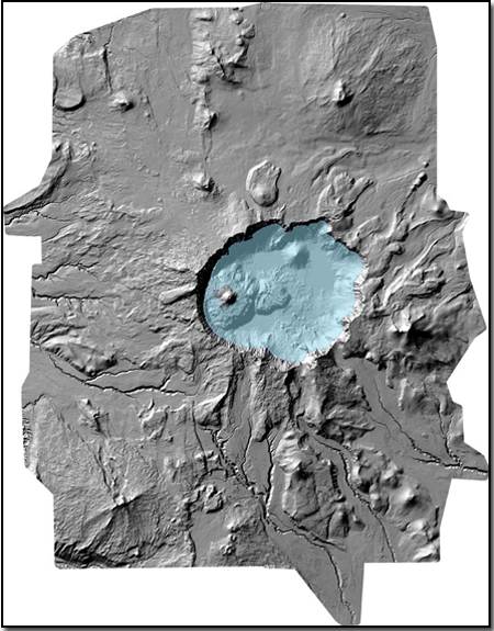
Crater Lake partially fills the caldera that formed approximately 7,700 years ago during the eruption of a 12,000-foot volcano known as Mount Mazama. The caldera-forming or climactic eruption of Mount Mazama devastated the surrounding landscape, left a thick deposit of pumice and ash in adjacent valleys, and spread a blanket of volcanic ash as far away as southern Canada. Because the Crater Lake region is potentially volcanically active, knowledge of past events is important to understanding hazards from future eruptions. Similarly, because the area is seismically active, documenting and evaluating geologic faults is critical to assessing hazards from earthquakes.
As part of the American Recovery and Reinvestment Act (ARRA) of 2009, the U.S. Geological Survey was awarded funding for high-precision airborne LiDAR (Light Detection And Ranging) data collection at several volcanoes in the Cascade Range through the Oregon LiDAR Consortium, administered by the Oregon Department of Geology and Mineral Industries (DOGAMI). The Oregon LiDAR Consortium contracted with Watershed Sciences, Inc., to conduct the data collection surveys. Collaborating agencies participating with the Oregon LiDAR Consortium for data collection in the Crater Lake region include Crater Lake National Park (National Park Service) and the Federal Highway Administration.
In the immediate vicinity of Crater Lake National Park, 798 square kilometers of LiDAR data were collected, providing a digital elevation dataset of the ground surface beneath forest cover with an average resolution of 1.6 laser returns/m2 and both vertical and horizontal accuracies of ±5 cm. The LiDAR data were mosaicked in this report with bathymetry of the lake floor of Crater Lake, collected in 2000 using high-resolution multibeam sonar in a collaborative effort between the U.S. Geological Survey, Crater Lake National Park, and the Center for Coastal and Ocean Mapping at the University of New Hampshire. The bathymetric survey collected 16 million soundings with a spatial resolution of 2 meters using an EM1002 system owned and operated by C&C Technologies, Inc.
The combined LiDAR and bathymetric dataset has a cell size of 1 meter and will contribute to understanding past volcanic events and their deposits, recognizing of faults and volcanic landforms, and quantifying landscape modification during and after the next volcanic eruption at Crater Lake.
|
-
This report is available only on the Web.
Part of this report is presented in Portable Document Format (PDF); the latest version of Adobe Reader or similar software is required to view it. Download the latest version of Adobe Reader, free of charge. |

