U.S. Geological Survey Data Series 74, Version 3.0
Long-Term Oceanographic Observations in Massachusetts Bay, 1989-2006
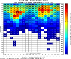
Hour-averaged and low-pass-filtered current observations were sorted into speed and direction bins to provide a measure of the most frequently observed current speeds and directions. The current observations are sorted into bins defined by 0.02-m/s speed intervals and 20-degree direction intervals, with direction measured clockwise from north. To produce each of the figures, the hour-averaged current observations at a given depth were sorted into speed and direction bins bounded by the speed values along the left side of the figure and the direction values along the bottom of the figure. For example, the upper left bin includes all currents of speeds less than 0.02 m/s flowing toward directions between 0 and 20 degrees. The color of each bin represents the percentage of the total observations in that bin and the number in the bin is the fraction, in percent. Bins with no observations are shown in white. The numbers on the right side of the figure are the percentages of current observations in each speed interval, added across all directions. The numbers across the bottom are the percentages of current observations in each direction interval, added across all speeds. The total number of points sorted and the percentage of possible observations (calculated as the total number of points sorted divided by the number of possible points in the year) at the bottom of the figure indicate the data coverage for each year. During some periods, two instruments were in the water simultaneously at the same site; this situation typically lasted only for short periods when an existing mooring was not recovered (usually due to operational issues) prior to deploying a replacement. In these cases, data for both instruments are included in the sort; therefore the percentage of possible observations may exceed 100. Figures showing current speed sorted by direction
LT-A, Point Current Meter Observations
LT-A, ADCP Observations
LT-B, ADCP Observations
|
|||||||||||||||||||||||||||||||||||||||||||||||||||