U.S. Geological Survey Data Series 74, Version 3.0
Long-Term Oceanographic Observations in Massachusetts Bay, 1989-2006
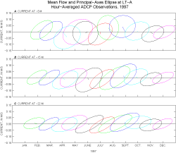
Plots of the monthly mean current and current ellipse illustrate the relative magnitude of the mean current and of the hour-averaged and low-pass-filtered current fluctuations. Plots of monthly observed vector-averaged mean current (shown as a line) and variability (as a principal ellipse centered around the tip of the mean flow line) were created for each year of observation. In these plots, the top of the page is to the north and the right of the page is to the east. The mean flow and ellipse were calculated for all months with more than 360 hours (15 days) of data. Typically, the current flows from the origin of the mean flow line toward any point within the current ellipse. The ellipse calculated from the hour-averaged data generally reflects the tidal currents, whereas the ellipse calculated from the low-pass-filtered data reflects current fluctuations caused by wind, density gradients, and circulation in the adjacent Gulf of Maine on time scales of a few days and longer. The values of the mean flow and principal ellipses shown in these plots can be found in the Statistics and Principal Axes sections of this report, respectively. Plots of monthly vector-averaged current and principal ellipse
|
|||||||||||||||||||||||||||||||||