U.S. Geological Survey Data Series 74, Version 3.0
Long-Term Oceanographic Observations in Massachusetts Bay, 1989-2006
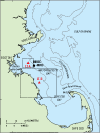
Meteorological ObservationsWind speed and direction, significant wave height, average wave period, dominant wave period, air temperature, sea-surface temperature, and barometric pressure are recorded by instruments maintained at station 44013 in Massachusetts Bay by the National Data Buoy Center (NDBC) (fig. 1) (table 2). During the long-term observations, the meteorological observations were made at several locations on different platforms. From 1989 to 1993, the meteorological observations were made from the Boston Approach Buoy, a 10-m Large Navigation Buoy (LNB) at LT-A. In 1993 the Boston Approach Buoy was replaced with a USCG Horn Buoy and the NDBC station 44013 was moved to a location about 7 km east of LT-A (fig. 1) where meteorological measurements were made from a 3-m discus buoy. Data collected from these buoys at 1-hour intervals were obtained from the National Data Buoy Center. Table 2. Location and platform type for NDBC Station 44013 in Massachusetts Bay, 1986–2006. Anemometer height in meters above surface. [m, meters; °, degrees; ', minutes; LNB, Large Navigational Buoy]
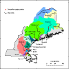
Streamflow ObservationsDaily streamflow observations were obtained from the U.S. Geological Survey. Streamflow from the Saint John, Penobscot, Androscoggin, Merrimack, Parker, and Ipswich Rivers (Streamflow gaging stations 01014000, 01034500, 01059000, 01100000, 01101000, and 01102000, respectively), which discharge into the western Gulf of Maine north of Cape Ann, and from the Charles River, which discharges through Boston Harbor into Massachusetts Bay (gaging station 01104500), are included in this report (fig. 15). |