Fact Sheet 010-94
U.S. Geological Survey Fact Sheet 010-94 (Published 1994)
By Brian Hughes
In 1991, the U.S. Geological Survey (USGS), U.S. Department of the Interior began a National Water-Quality Assessment Program (NAWQA). The long-term goals of NAWQA are to describe the status of and trends in the quality of a large representative part of the Nation's surface- and ground-water resources and to identify all the major factors that affect the quality of these resources. In addressing these goals, the NAWQA produces water-quality information that is useful to policy makers and managers at Federal, State, and local levels.
NAWQA emphasis is on regional scale water-quality problems. The program does not diminish the need for smaller scale studies and monitoring designed and conducted by Federal, State, and local agencies. NAWQA, however, provides a large-scale framework for conducting many of these activities and an understanding about regional and national water-quality conditions that cannot be acquired from these other programs and studies.
Studies of 60 hydrologic systems that include parts of most major river basins and aquifer systems are the building blocks of the national assessment. The areas of the 60 study units range in size from 1,000 to more than 60,000 square miles (mi2) and represent 60 to 70 percent of the Nation's water use and population served by public-water supplies. Twenty investigations were begun in 1991, 20 investigations began in 1994, and 20 are planned to begin in1997. The assessment activities in the Santee River Basin and Coastal Drainage began in 1994.
THE SANTEE BASIN AND COASTAL DRAINAGE
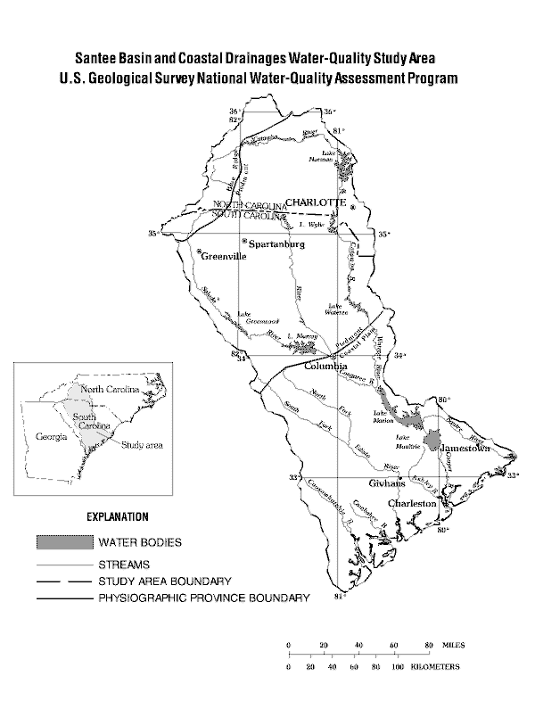
The 24,868 mi2 study area includes parts of North Carolina (4,695 mi2) and South Carolina (20,173 mi2) and extends across parts of three physiographic provinces--the Blue Ridge, the Piedmont, and the Coastal Plain. In 1990, it had a population of 3,618,755 and contained four major metropolitan areas-- Greenville-Spartanburg, Columbia, Charleston, and Charlotte. Surface and ground water provided 86 and 14 percent of the public water supply in 1990 respectively. According to 1970 data, the study area is about 63 percent forested; 7 percent, urban; 18 percent, cropland; 7 percent, pasture; and 4 percent, water. The largest industries are textile, paper, and chemical.
About 65 percent of the study area lies in the Santee River Basin and 35 percent in the basins of smaller streams that drain coastal areas of southeastern South Carolina. The Santee River is the second largest river on the eastern coast of the United States, second only to the Susquehanna River in drainage area and flow. The headwaters of the Santee River are in the mountains of North Carolina, and the river flows about 413 miles across the Piedmont and Coastal Plain to the Atlantic Ocean. The coastal drainage consists of the Ashley, the Cooper, the Edisto, the Combahee, and the Coosawhatchie River Basins. These streams originate in the Coastal Plain and range in length from less than 10 miles (mi) for some of the smaller creeks to 150 mi for the Edisto. The waters in the lower reaches of the rivers are brackish and affected by tides.
The flow in the Santee River near Jamestown, S.C. averaged 11,408 cubic feet per second (ft3/s) during 1987-91 and the highest and lowest daily mean flows were 89,500 ft3/s and 460 ft3/s, respectively. Much of the flow from the river is diverted across a drainage divide from Lake Marion to Lake Moultrie in the Cooper River Basin. Consequently the flow in the Cooper River Basin is high in relation to its drainage area. During 1987-91, the mean annual flow in the Cooper River below the Lake Moultrie tailrace canal was 5,349 ft3/s and the highest and lowest daily mean flows were 26,800 ft3/s and 0 ft3/s, respectively. The flows in the coastal drainage rivers are smaller because of their smaller drainage areas. The mean annual flow of the Edisto River near Givhans for 1939-91 was 2,609 ft3/s, and the highest and lowest daily mean flows were 24,100 ft3/s and 252 ft3/s, respectively.
The largest surface-water impoundments in the study area are Lakes Norman (32,510 acres), Murray (51,000 acres), Moultrie (60,400 acres), and Marion (110,600 acres). Much of the sediment carried by the Santee River is deposited in Lakes Marion and Moultrie; however, some fine-grained sediment moves through the Lake Moultrie spillway and increases the sediment load in the Cooper River. The diversion of water from the Santee Basin into the Cooper Basin in 1941 caused a large increase in flow in the Cooper River and an increase in erosion and sediment load transported by the river. Because much of the increased sediment load was deposited in Charleston Harbor, water from Lake Moultrie was rediverted into the Santee Basin in 1986.
About 50 percent of the study area is in the Piedmont, 40 percent is in the Coastal Plain, and 10 percent is in the Blue Ridge. The ground-water resources are dependent on the lithology of the rocks that underlie the area, which differs among the three physiographic provinces. The Piedmont is underlain by metamorphosed igneous and sedimentary rocks, with a thick layer of saprolite, or weathered rock that covers the bedrock. Industrial and municipal supplies of ground water in the Piedmont generally are obtained from deep wells that tap joints and fractures in the bedrock. Small supplies of ground water, primarily for domestic uses, are obtained from shallow wells that tap pore spaces in saprolite. The Coastal Plain is underlain by seaward thickening layers of sand, silt, clay, and limestone. Usable ground-water in the Coastal Plain is located within the pore spaces of coarse-grained deposits and is extensively developed as a water supply for industrial and municipal use. The Blue Ridge is underlain by consolidated rock and saprolite. Ground-water is obtained from wells that intersect fractures and joints in this part of the study area, although well yields are commonly small.
In 1990, withdrawals of ground and surface water for municipal, power generation, agricultural, and industrial uses totaled 6.5 billion gallons per day (Bgal/d). Power generation was the biggest water use and accounted for 5.6 Bgal/d. Industrial use accounted for 425 million gallons per day (Mgal/d), municipal use, 347 Mgal/d, and agricultural use, 70 Mgal/d. About 3 percent of the withdrawals were for consumptive uses. Instream use by hydroelectric plants was 49.3 Bgal/d in 1990.
MAJOR WATER-QUALITY ISSUES
The following water-quality issues have been tentatively identified as high priority, regional-scale issues of concern to the State and local water-resource managers and are addressed by the Santee-Coastal NAWQA study:
COMMUNICATION AND COORDINATION
Communication and coordination between the USGS and the public and private sectors are critical components of NAWQA. Study-unit liaison committees have proved highly effective and consist of representatives from Federal, State, and local agencies; universities; and the private sector who have water-resources responsibilities or interests. Specific activities of each liaison committee include:
--W. Brian Hughes
Information on technical reports and hydrologic data related to the NAWQA program can be obtained from:
Project Chief -- Santee River Basin and Coastal Drainages NAWQA Study
U.S. Geological Survey, WRD
Stephenson Center, Suite 129
720 Gracern Road
Columbia, SC 29210-7651
(803) 750-6100

![]() U.S. Department of the Interior |
U.S. Geological Survey
U.S. Department of the Interior |
U.S. Geological Survey
URL: http://pubsdata.usgs.gov/pubs/fs/1994/fs-010-94/index.html
Page Contact Information: GS Pubs Web Contact
Page Last Modified: Tuesday, 29-Nov-2016 18:02:08 EST