| Latest Quake Info | General Quake Info | Hazards & Preparedness | Earthquake Research | Special Features | Additional Resources |

Scientists recently discovered strong evidence that great earthquakes (magnitude 8 to 9) have repeatedly struck the Pacific Northwest in the past several thousand years, most recently about 300 years ago. This discovery has spurred the reinforcement of existing structures and changes in building codes in the region--measures that will save lives and reduce damage in future earthquakes.
The mighty Pacific Northwest earthquake lasted a minute or more and seemed to go on forever. Soon after the shaking stopped, a roar along the Pacific coast announced the oncoming tsunami--a series of huge ocean waves caused by the earthquake. Years later, survivors would tell their grandchildren about endless shaking and the sea that surged far ashore. But most stories were eventually lost, and people forgot that this earthquake had ever struck the region. For the earthquake happened about A.D. 1700, generations before the words of native Northwesterners were first written down.
Past occurrences of very powerful earthquakes in the Pacific Northwest went unrecognized by earth scientists until the mid-1980's. Had such an earthquake occurred earlier in this century, Northwesterners would have been taken by complete surprise. Now, warned by earth scientists, residents of the Pacific Northwest have taken new steps to reduce their vulnerability to future earthquake losses. Earthquake design standards in Oregon and Washington have been toughened, and many existing structures have been reinforced.
 (Click
on image for a full size version, 36K)
(Click
on image for a full size version, 36K)
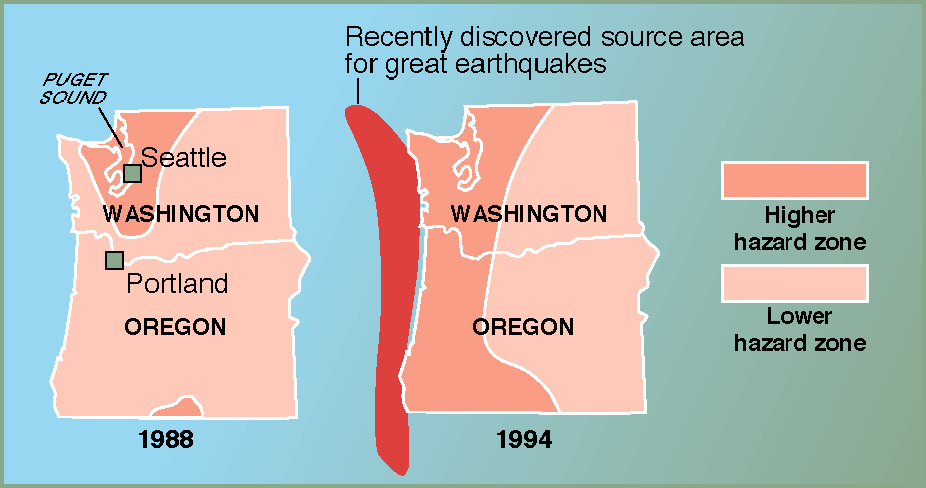
In the early 1990's, engineers and public officials redrew a map of earthquakeshaking
hazards in the Pacific Northwest. The map is part of the Uniform Building Code,
which includes minimum standards for designing earthquake-resistant structures
nationwide. The map shows two zones of earthquake-shaking hazard. The zone of
higher hazard (zone 3 in the code) is the second highest hazard level nationwide.
The expansion of this higher hazard zone on the 1994 version of the map was driven
largely by the discovery of evidence that great earthquakes (magnitude 8 to 9)
have struck the Pacific Northwest in the recent geologic past.
Such increased efforts to reduce future earthquake losses did not seem necessary in 1980. Then, the recognized threat was limited to earthquakes of about magnitude 7. In the 1980's, however, earth scientists discovered that the Pacific Northwest is threatened by great earthquakes-shocks of magnitude 8 to 9. These shocks would be at least as large as the biggest earthquakes of this century in the lower 48 states; they would release 30 to 1,000 times more energy than an earthquake of magnitude 7.
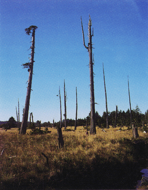
The story of the efforts to meet this earthquake threat begins decades earlier, when earth scientists first recognized that the Pacific Northwest contains a boundary between two of the tectonic plates that make up the Earth's surface. This boundary-along the Pacific coast between southern British Columbia and northern California-is the largest active fault in North America outside Alaska. Most great earthquakes elsewhere around the Pacific Rim occur on similar plate boundaries. Great earthquakes in the early 1960's in Alaska and Chile, for example, bowed nearby coastlines downward by as much as 8 feet, flooding them with sea water that killed many square miles of forest.
Led by U.S. Geological Survey researchers, scientists in the mid-1980's discovered similar but much older remains of flooded forests in coastal Washington, Oregon, and northern California. They also found sheets of sand deposited by tsunamis and sand-filled cracks caused by strong earthquake shaking. From this evidence, they concluded that large earthquakes had struck the Pacific Northwest repeatedly in the past several thousand years, most recently about A.D. 1700. Most of these scientists further concluded that the earthquakes were magnitude 8 or larger.
 (Click on image for a full size version, 200K)
A dead forest in coastal Washington records a great earthquake that occurred about
A.D. 1700, a century before Lewis and Clark explored the mouth of the nearby Columbia
River. Such forests are among the evidence that areas of the Pacific Northwest
have experienced earthquakes of magnitude 8 to 9 in the past and are likely to
experience them again in the future.
In 1989, when a magnitude-7.1 earthquake struck northern California during the live broadcast of the World Series, much of the nation was watching. Northwesterners, like many other Americans, were disturbed by the scenes of earthquake damage that followed and wondered if a similar disaster could strike them. By this time, many engineers and public officials had been informed about the great-earthquake threat in the Pacific Northwest. Soon after, partly in response to this threat, engineers and public officials began to revise the Uniform Building Code for Oregon and Washington.
The Uniform Building Code contains nationwide standards for designing structures. Some of these standards vary in relation to expected levels of earthquake shaking. The code defines six levels of earthquake-shaking hazard. Before 1994, the code placed the Puget Sound area of Washington, including Seattle, in a zone having the second highest hazard level, and most of the rest of Oregon and Washington was placed in a zone having the next lower hazard level. The 1994 edition of the Uniform Building Code, however, extends the higher level hazard zone to include all parts of Oregon and Washington that are near potential sources of great earthquakes.
This revision of the Uniform Building Code is an important first step toward meeting the great-earthquake threat in the Pacific Northwest. In the areas upgraded to the second highest level of earthquake-shaking hazard, new buildings are now designed to resist earthquake forces 50% stronger than they were under the old code. The cost of these new requirements rarely exceeds a few percent of the total cost for a new building.
 (Click on image for a full size version, 249K)
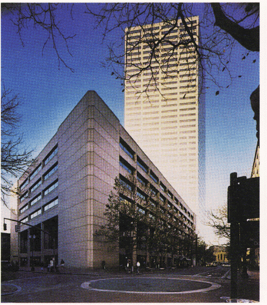
This U.S. Bancorp building (foreground) in Portland, Oregon, was strengthened
for a cost of $8 million in 1993-1994 to withstand strong earthquakes. The building
now exceeds 1994 earthquake-resistant design standards in the Uniform Building
Code.
Discoveries about great earthquakes also helped convince public officials and corporate executives to strengthen some of the existing dams, bridges, water systems, schools, and factories in the Pacific Northwest. More than $130 million has been invested in such seismic upgrades since 1988.
 (Click on image for a full size version, 17K)
From 1988 to 1995, the public and private sectors invested more than $130 million
to strengthen dams, bridges, lifelines (electrical, gas, and water lines), and
buildings against earthquakes in the Pacific Northwest. These upgrades in earthquake
resistance reduce the region's vulnerability to losses of life and property from
future earthquakes.
Difficult decisions must still be made about preparing for future earthquakes in the Pacific Northwest:
Similarly difficult questions about preparing for future earthquakes are also
being asked in other earthquake-prone states, such as Massachusetts, New York,
South Carolina, Missouri, Indiana, Utah, California, and Alaska. Many of these
questions cannot be answered satisfactorily without more knowledge of earthquakes
from the geologic past. In the Pacific Northwest, such knowledge has identified
an earthquake hazard that otherwise might have taken residents by surprise.
Deciphering the geologic past is one of the ways that earth scientists help
to protect citizens of the United States from loss of life and property in the
future.
Brian F. Atwater, Thomas
S. Yelin, Craig S. Weaver, and James
W. Hendley II
COOPERATING ORGANIZATIONS
Geological Survey of Canada
Nuclear Regulatory Commission
Oregon Department of Geology and Mineral Industries
Structural Engineers Association of Oregon
Structural Engineers Association of Washington
Washington Division of Geology and Earth Resources
For more information contact the authors or:
Seismology Information (206) 543-7010
Box 351650
University of Washington
Seattle, WA 98195-1650
U.S. Geological Survey Fact Sheet-111-95, March 1995
URL: https://pubs.usgs.gov/fs/1995/fs111-95/
For more information contact:
Earthquake Information Hotline (650) 329-4085
U.S. Geological Survey, MS 977
345 Middlefield Road, Menlo Park, CA 94025
USGS Menlo Park Earthquakes Home Page
or
UW Earthquakes Page
U.S. Geological Survey Fact Sheet-111-95, March 1995
Web page by Will Prescott - 1997 May 14. Last revision by Michael Diggles January 5, 2007
