Fact Sheet 1998–0090
The timely warning of a flood is crucial to the protection of lives and property. One has only to recall the flood of August 2, 1973, in Somerset County, New Jersey, in which six lives were lost and major property damage occurred, to realize how unexpected and costly, especially in terms of human life, a flood can be. Accurate forecasts and warnings cannot be made, however, without detailed information about precipitation and streamflow in the drainage basin.
Recognizing the need for detailed hydrologic information for Somerset County, the U.S. Geological Survey (USGS), in cooperation with Somerset County, installed the Somerset County Flood Information System (SCFIS) in 1990. The availability of data provided by this system will improve the flood forecasting ability of the National Weather Service (NWS), and has assisted Somerset County and municipal agencies in planning and execution of flood-preparation and emergency evacuation procedures in the county.
This fact sheet describes the Somerset County Flood Information System and identifies its benefits.Since the mid 1960's the NWS has been able to effectively forecast flooding on larger streams in Somerset County, such as the Raritan and Millstone Rivers. Flooding on smaller streams in urban areas is more difficult to predict, however. In response to this problem the NWS, in cooperation with the Green Brook Flood Control Commission, installed a rain gage in North Plainfield, and two flash-flood alarms, one on Green Brook at Seeley Mills and one on Stony Brook at Watchung, in the early 1970's.
In 1978, New Jersey's first local flood-warning system was installed by the USGS in Somerset County. This system consisted of a network of eight streamflow-gaging stations equipped with rain gages and linked by telephone telemetry, and eight auxiliary rain gages. The gages were installed throughout the county to collect rainfall and runoff data that could be used to improve flood-monitoring capabilities and flood-frequency estimates.
Information needed for flood forecasting includes stream stage (the height of the water level in the stream above an arbitrary datum) and the amount and distribution of precipitation. Streamflow is measured at a steamflow-gaging station, where automated equipment is used to continuously monitor and record water levels. Because stream discharge, or the volume that flows past a point on the stream during a specific time interval, is difficult to measure accurately and continuously, discharge is commonly estimated from preestablished stage-discharge relations, or rating curves. The rating curves are developed by USGS personnel who visit the gaging station periodically to measure discharge manually under a variety of flow conditions. The rating curve also allows stream stage to be determined from an estimate of stream discharge.
Precipitation gages distributed throughout the drainage basin are used to measure and record the amount of precipitation that falls during a given storm. This information, together with the NWS's Doppler radar, allows the amount and distribution of precipitation to be accurately estimated. From this estimate, stream discharge at a given location can be predicted and converted to an estimate of stream stage.
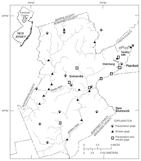
Figure 1. Locations of Somerset County Flood Information System gages in Somerset County, N.J., and vicinity. |
In early 1990, the USGS replaced the telephone telemetry of the first network with radio links between the gaging stations and the base-station computer. During the same period 5 stream gages and 10 rain gages, as well as connections to 1 Passaic Flood Warning System (PFWS) and 5 NWS streamflow gages, were added to the network. The new streamflow gages were placed at critical flood-prone locations to provide real-time indications of imminent flooding. The additional rain gages were installed throughout the county to provide much needed information on the spatial distribution of rainfall, especially heavy precipitation.
In 1996 and 1997 the system was adjusted further, some gages were added and others were removed. Currently, the network consists of 23 streamflow gages and 21 rain gages; their locations are shown in figure 1.
The base-station computer, located at the Somerset County Engineering Division in the Somerset County administration building in Somerville, N.J., receives the streamflow and rainfall data by very high frequency (VHF) radio link and telephone and uses a software configuration based onthe NWS's ALERT software to record the incoming data. The radio communication links provide continuous, real-time reports on streamflow, while the telephone links provide intermittent data.
Information on stage, discharge, and precipitation within the Passaic River Basin is obtained through a UHF-radio link with the PFWS, installed just north of Somerset County. The Passaic Flood Warning System, completed in 1988, encompasses parts of 10 counties in New York and New Jersey, and consists of 35 rain gages, 21 streamflow-gaging stations, and 12 base-station computers. The backbone communication network for the PFWS ties together the base-stations of the 4 counties, the 3 NWS offices, the Army Corps of Engineers in New York, the N.J. State Police, the N.J. Dept. of Environmental Protection, and the USGS. The NWS flood watches, warnings, and weather forecasts are relayed over the backbone network along with precipitation and stream-stage data to keep all base-station computers up to date. The link with the PFWS also enables the Somerset County system to be part of the New Jersey Integrated Flood Observations and Warning System (IFLOWS) network.
IFLOWS is a software package designed for the NWS that enables the two-way transfer of messages and the one-way transfer of forecasts, warnings, guidance, and data between the NWS internal communications systems and the base-station computers of the SCFIS and PFWS. Currently, both the SCFIS and PFWS use a proprietary software package called DataCommand1.This package is an enhanced version of ALERT (a NWS software package) that facilitates the exchange of data between base stations and IFLOWS systems.
The Somerset County Flood Information System provides valuable information that benefits the residents of Somerset County, the State of New Jersey, and Federal agencies that regulate the county's waterways.
Somerset County Division of Engineering (908) 231-7024
Summer, W.M., 1998, Somerset County flood information system: U.S. Geological Survey Fact Sheet 1998-0090, https://pubs.usgs.gov/fs/1998/0090.

![]() U.S. Department of the Interior |
U.S. Geological Survey
U.S. Department of the Interior |
U.S. Geological Survey
URL: http://pubsdata.usgs.gov/pubs/fs/1998/0090/index.html
Page Contact Information: GS Pubs Web Contact
Page Last Modified: Tuesday, 29-Nov-2016 18:10:08 EST
