Skip Links

USGS - science for a changing world

Fact Sheet 108–00

National Land Cover Dataset

By U.S. Geological Survey

Archived Publication—Most of the information contained in this publication is no longer current and is not expected to be updated.

Thumbnail of and link to report PDF (148 KB)Summary

The U.S. Geological Survey (USGS), in cooperation with the U.S. Environmental Protection Agency, has produced a land cover dataset for the conterminous United States on the basis of 1992 Landsat thematic mapper imagery and supplemental data. The National Land Cover Dataset (NLCD) is a component of the USGS Land Cover Characterization Program. The seamless NLCD contains 21 categories of land cover information suitable for a variety of State and regional applica-tions, including landscape analysis, land man-agement, and modeling nutrient and pesticide runoff. The NLCD is distributed by State as 30-meter resolution raster images in an Albers Equal-Area map projection.

First posted July 2000

Supersedes FS 136–99—No online version

Supersedes FS 048–97—No online version

Part or all of this report is presented in Portable Document Format (PDF); the latest version of Adobe Reader or similar software is required to view it. Download the latest version of Adobe Reader, free of charge.


Suggested citation:

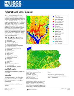
U.S. Geological Survey, 1996, National Land Cover Dataset: U.S. Geological Survey Fact Sheet 108–00, 1 p., available only online at https://pubs.usgs.gov/fs/2000/0108/.


Accessibility FOIA Privacy Policies and Notices

Take Pride in America logo USA.gov logo U.S. Department of the Interior | U.S. Geological Survey
URL: http://pubsdata.usgs.gov/pubs/fs/2000/0108/index.html
Page Contact Information: GS Pubs Web Contact
Page Last Modified: Tuesday, 29-Nov-2016 18:14:01 EST