U.S. Geological Survey Fact Sheet 036-00
Online Version 1.0
U.S. Geological Survey Fact
Sheet 036-00
Online Version 1.0
| Mount St. Helens, Washington, is the most active volcano in the Cascade Range. Its most recent series of eruptions began in 1980 when a large landslide and powerful explosive eruption created a large crater, and ended 6 years later after more than a dozen extrusions of lava built a dome in the crater. Larger, longer lasting eruptions have occurred in the volcano's past and are likely to occur in the future. Although the volcano seems to have returned to a period of quiet, scientists with the U.S. Geological Survey and University of Washington Geophysics Program continue to closely monitor Mount St. Helens for signs of renewed activity. |
The first sign of activity at Mount St. Helens in the spring of 1980 was a series of small earthquakes that began on March 16. After hundreds of additional earthquakes, steam explosions on March 27 blasted a crater through the volcano's summit ice cap. Within a week the crater had grown to about 1,300 feet in diameter and two giant crack systems crossed the entire summit area. By May 17, more than 10,000 earthquakes had shaken the volcano and the north flank had grown outward at least 450 feet to form a noticeable bulge. Such dramatic deformation of the volcano was strong evidence that molten rock (magma) had risen high into the volcano
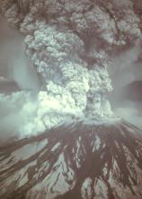
Within 15 to 20 seconds of a magnitude 5.1 earthquake at 8:32 a.m., the volcano's bulge and summit slid away in a huge landslide - the largest on Earth in recorded history. The landslide depressurized the volcano's magma system, triggering powerful explosions that ripped through the sliding debris. Rocks, ash, volcanic gas, and steam were blasted upward and outward to the north. This lateral blast of hot material accelerated to at least 300 miles per hour, then slowed as the rocks and ash fell to the ground and spread away from the volcano; several people escaping the blast on its western edge were able to keep ahead of the advancing cloud by driving 65 to 100 miles an hour! The blast cloud traveled as far as 17 miles northward from the volcano and the landslide traveled about 14 miles west down the North Fork Toutle River.
The lateral blast produced a column of ash and gas (eruption column) that rose more than 15 miles into the atmosphere in only 15 minutes. Less than an hour later, a second eruption column formed as magma erupted explosively from the new crater. Then, beginning just after noon, swift avalanches of hot ash, pumice, and gas (pyroclastic flows) poured out of the crater at 50 to 80 miles per hour and spread as far as 5 miles to the north. Based on the eruption rate of these pyroclastic flows, scientists estimate that the eruption reached its peak between 3:00 and 5:00 p.m. Over the course of the day, prevailing winds blew 520 million tons of ash eastward across the United States and caused complete darkness in Spokane, Washington, 250 miles from the volcano.
During the first few minutes of this eruption, parts of the blast cloud surged over the newly formed crater rim and down the west, south, and east sides of the volcano. The hot rocks and gas quickly melted some of the snow and ice capping the volcano, creating surges of water that eroded and mixed with loose rock debris to form volcanic mudflows (lahars). Several lahars poured down the volcano into river valleys, ripping trees from their roots and destroying roads and bridges.
The largest and most destructive lahar was formed by water seeping from inside the huge landslide deposit through most of the day. This sustained flow of water eroded material from both the landslide deposit and channel of the North Fork Toutle River. The lahar increased in size as it traveled downstream, destroying bridges and homes and eventually flowing into the Cowlitz River. It reached its maximum size at about midnight in the Cowlitz River about 50 miles downstream from the volcano.
|
|
Summary of May 18, 1980 Eruption of Mount St. Helens |
||||||||||||||||||||||||||||||||||||||||||||||||||||||||||||||||||||||||||||||||||||||||||||||||||||||||||||||||||||||||||
| ||||||||||||||||||||||||||||||||||||||||||||||||||||||||||||||||||||||||||||||||||||||||||||||||||||||||||||||||||||||||||
|
* Volumes are based on uncompacted deposits |
||||||||||||||||||||||||||||||||||||||||||||||||||||||||||||||||||||||||||||||||||||||||||||||||||||||||||||||||||||||||||
Five smaller explosive episodes occurred during the summer and fall of 1980. Each produced eruption columns 8 to 9 miles above sea level and pyroclastic flows down the volcano's north flank. The episodes in June, August, and October also erupted lava in the crater to form a dome. Lava domes are mound- shaped features that form when stiff, viscous lava accumulates over and around a volcanic vent. The June and August domes were destroyed by subsequent explosive episodes.
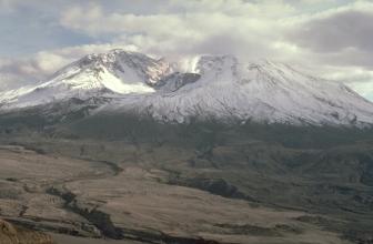
Beginning with the October 1980 eruption, 17 eruptive episodes built a new lava dome that reached 876 feet above the crater floor. Minor explosive activity and (or) lahars accompanied several of the 1981 to 1986 episodes. Each of the dome-building episodes added between 1 and 29 million cubic yards of new lava to the dome. Most of the growth occurred when magma extruded onto the surface of the dome, forming short (650 to 1,300 feet), thick (65 to 130 feet) lava flows. During a 12-month-long episode beginning in 1983, however, magma moved primarily into the dome's molten interior, pushing its east side outward by at least 250 feet. In addition to the 17 dome-building episodes, hundreds of small explosions or bursts of gas and steam occurred, sending ash a few hundred feet to several miles above the volcano. The larger explosions showered the crater with rocks and occasionally generated small lahars.
Since late 1986 several periods of increased seismicity have occurred. Between 1989 and 1991 there were about 30 bursts of brief but intense seismic activity lasting minutes to hours. Several of these bursts were accompanied by small explosions from the dome. The explosions formed a new vent on the north side of the dome and produced small eruption columns that rose a few miles above the volcano. A few explosions also hurled hot rocks three feet in diameter at least 1/2 mile northward from the dome, generated small pyroclastic flows in the crater, and formed small lahars. During 1995 and 1998 seismicity increased for several months, but there were no accompanying explosions.
|
Magmatic Eruptions Since May 18, 1980 | |||||||||||||
|
Date* |
Explosive activity |
Pyroclastic flows |
Lava flows (dome) |
Lahars |
Erupted volume** (million cubic yards) |
||||||||
| 05/25/80 | X | X | 41.8 | ||||||||||
| 06/12/80 | X | X | X | 54.5 | |||||||||
| 07/22/80 | X | X | 13.1 | ||||||||||
| 08/07/80 | X | X | X | 7.2 | |||||||||
| 10/16/80 | X | X | X | 3.6 | |||||||||
| 12/27/80 | X | 2.1 | |||||||||||
| 02/05/81 | X | 4.7 | |||||||||||
| 04/10/81 | X | 5.4 | |||||||||||
| 06/18/81 | X | 5.4 | |||||||||||
| 09/06/81 | X | 5.1 | |||||||||||
| 10/30/81 | X | 4.7 | |||||||||||
| 03/19/82 | m | X | X | 4.4 | |||||||||
| 05/14/82 | X | 3.5 | |||||||||||
| 08/18/82 | X | 6.0 | |||||||||||
| 02/07/83*** | X | X | 29.3 | ||||||||||
| 03/29/84 | X | 1.4 | |||||||||||
| 06/17/84 | X | 1.2 | |||||||||||
| 09/10/84 | X | 4.8 | |||||||||||
| 05/24/85 | X | 5.6 | |||||||||||
| 05/08/86 | X | m | 7.6 | ||||||||||
| 10/21/86 | X | 8.0 | |||||||||||
| |||||||||||||
|
|
||||||||
|
By
Steve Brantley and Bobbie Myers
Banner by Bobbie Myers
Web design by Carolyn Donlin
For more information or copies of the paper version of this fact sheet contact:
U.S. Geological Survey
David A. Johnston Cascades Volcano Observatory
5400 MacArthur Blvd., Vancouver, WA 98661
Tel: (360) 993-8900, Fax: (360) 993-8980
e-mail: cvo@usgs.gov
Also, visit the Cascades Volcano Observatory on the Web.
COOPERATING ORGANIZATIONS
U.S Department of Agriculture, Forest Service
University of Washington, Geophysics Program
Related Fact Sheets
Living With Volcanic Risk in the Cascades
PDF version of this two-page fact sheet (352 KB)
U.S. GEOLOGICAL SURVEY–REDUCING THE RISK FROM VOLCANO HAZARDS
Learn more about
volcanoes and the hazards they pose at the
USGS
Volcano Hazards Program website