
U.S. Geological Survey Fact Sheet 059-00
Online Version 1.0
U.S. Geological Survey
Fact Sheet 059-00
Online Version 1.0
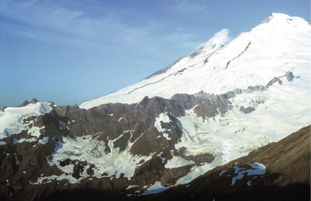
| Mount Baker dominates the skyline from Bellingham, Washington, and Vancouver, British Columbia. On cold, clear winter days, dramatic increases in the steam plume rising continuously from Sherman Crater can alarm local residents. This apparent increase in plume vigor occurs because of condensation of steam in cold, calm air. In 1975, however, increased steaming and melting of snow and ice around Sherman Crater did signify a change in heat output from the volcano's interior. Although the increased heat flow gradually subsided, it could have signaled the start of eruptive activity, and precautions were wisely undertaken. So that the public can be warned of, and be prepared for, future eruptions and other hazardous events at Mount Baker, U.S. Geological Survey (USGS) scientists are studying the volcano's past behavior and monitoring its current activity. |
|
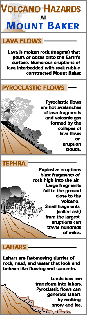
The next eruption of Mount Baker may produce lava flows, pyroclastic flows, volcanic ash (tephra), and lahars . Lahars are by far the greatest concern at Mount Baker because of its history of frequent lahars, the ability of lahars to flow for tens of miles, and the potential for hazardous future impacts of lahars on two reservoirs on the east side of the volcano. Tephra hazards at Mount Baker are less important than at neighboring Glacier Peak volcano to the south.
Lahars can originate in two ways:
1)During eruptions, pyroclastic flows can melt snow and ice to create torrents
of ash, rock, and water that move downvalley as sandy (noncohesive) lahars.
2)Because the volcano is locally weakened and altered to clay by percolating,
acidic, hot water and steam (like that venting from Sherman Crater), future
volcanic landslides known as flank collapses can mobilize to form muddy
(cohesive) lahars.
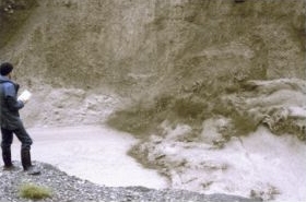
Lahars of collapse origin occur during eruptions. They also occur during non-eruptive periods triggered by regional earthquakes, gravity, or increases in hydrovolcanic activity not associated with magma intrusion.
When ground water comes in contact with either magma or hot rock, hydrovolcanic explosions of steam and rock can occur. Such events, in addition to possibly triggering collapse, can themselves be hazardous.
USGS research in the last decade shows Mount Baker to be the youngest of several volcanic centers in the area and one of the youngest volcanoes in the Cascade Range. Volcanic activity in the Mount Baker area began more than one million years ago, but many of the earliest lava and tephra deposits have been removed by glacial erosion. The pale-colored rocks northeast of the modern volcano mark the site of ancient Kulshan Caldera that collapsed after an enormous ash eruption one million years ago. Subsequently, eruptions in the Mount Baker area have produced cones and lava flows of andesite, the rock that makes up much of other Cascade Range volcanoes like Mounts Rainier, Adams, and Hood. From about 900,000 years ago to the present, numerous andesitic volcanic centers in the area have come and gone, eroded by glaciers. The largest is the Black Buttes edifice, active between 400,000 and 300,000 years ago and formerly bigger than today's Mount Baker.
Although numerous in Oregon and southern Washington, cinder cones formed of the rock type called basalt are rare around Mount Baker. A cinder cone that formed 9,800 years ago in Schriebers Meadow produced a widespread tephra layer, and lava flows that reached the Baker River.
|
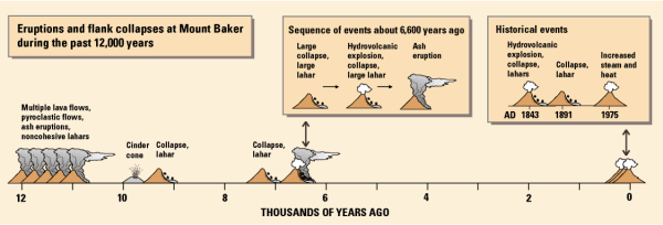
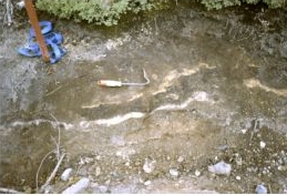
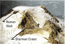
Modern Mount Baker formed during and since the last ice age, which ended about 15,000 years ago. Lava flows from the summit vent erupted between 30,000 and 10,000 years ago and, during the final stages of edifice construction, blocky pyroclastic flows poured down most of the volcano's drainages. An eruption 6,600 years ago produced a blanket of ash that extended more than 20 miles to the northeast. This eruption probably occurred from the presently ice-filled summit crater. Subsequently, sulfurous gases have found two pathways to the surface— Dorr Fumaroles, northeast of the summit, and Sherman Crater, south of the summit. Both these area are sites of pervasive bedrock alteration, converting lavas to weak, white-to-yellow material rich in clays, silica, and sulfur-bearing minerals. At Sherman Crater, collapses of this weakened rock created lahars in 1843 and as recently as the 1970's.
Like most volcanoes, Mount Baker's history records great variations in behavior. Scientists believe the following case histories are good examples of the range in size and types of hazardous activity that have occurred in the past and could occur again. Small events are more common than large ones, and during a future hazardous event only parts of the hazard zones shown on the map may be affected.
|
|
|
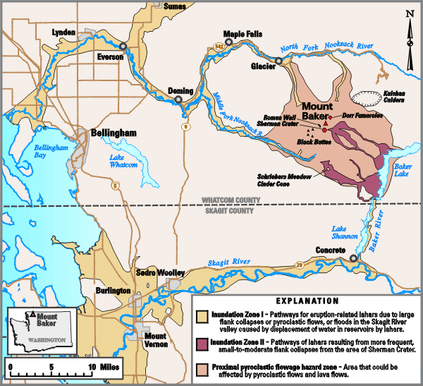
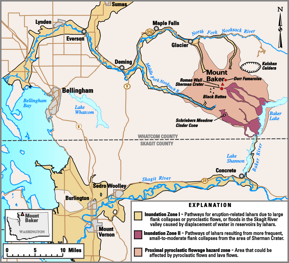
A series of discrete events culminated with the largest tephra-producing eruption in post- glacial time at Mount Baker. First, the largest collapse in the history of the volcano occurred from the Roman Wall (see map) and transformed into a lahar that was over 300 feet deep in the upper reaches of the Middle Fork of the Nooksack River. It was at least 25 feet deep 30 miles downstream from the volcano and probably reached Bellingham Bay. Next, a huge hydrovolcanic explosion occurred near the site of present day Sherman Crater, triggering a second collapse of the flank just east of the Roman Wall. That collapse also became a lahar that mainly followed the course of the first one for at least 20 miles, but also spilled into tributaries of the Baker River. Finally, an eruption cloud deposited several inches of ash as far as 20 miles downwind to the northeast.
The present shape of Sherman Crater originated with a large hydrovolcanic explosion. In 1843, explorers reported a widespread layer of newly fallen rock fragments "like a snowfall" and the forest "on fire for miles around." Rivers south of the volcano were clogged with ash, and Native Americans reported that many salmon were killed. A short time later, two collapses of the east side of Sherman Crater produced two lahars, the first and larger of which flowed into the natural Baker Lake, raising its level at least 10 feet. The location of this 19th-century lake is now covered by waters of the modern dam-impounded Baker Lake. Similar but lower level hydrovolcanic activity at Sherman Crater continued intermittently for several decades afterwards.
|
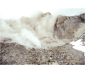
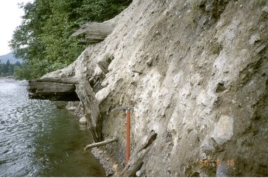
In 1891, about 20 million cubic yards of rock fell from the scar shown in the photo on the front page, producing a lahar that traveled more than 6 miles and covered 1 square mile.
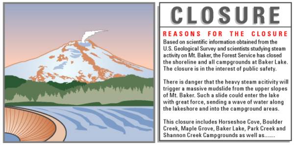
In 1975, scientists believed that the dramatic increase in the steam plume and heat output from Sherman Crater could herald either a new magmatic eruption or hydrovolcanic activity like that of 1843. Either of these possibilities would have increased the risk of collapse, raising concerns that lahars could flow rapidly into Baker Lake or Lake Shannon, displacing water and creating a flood surge or even causing dam failure. The volcano was subjected to the most intensive monitoring ever applied to a Cascade Range volcano up to that time. As time passed, no signs of rising magma— earthquakes, significant changes in gas composition, or surface deformation— appeared. The main risk, therefore, was of flank collapses and lahars similar to those of 1843 (Map Inundation Zone II). Had magmatic activity been confirmed, a much larger collapse and flow would have been possible (Map Inundation Zone I), and a magmatic eruption could have ensued like those between 30,000 and 10,000 years ago or that of 6,600 years ago.
When magmatic activity does recur, all the drainages of Mount Baker will be at risk from lahars, and upstream areas will be at risk from pyroclastic flows and lava flows in the hazard zone shown on the map. The Dorr Fumaroles are also a potential site of hydrovolcanic explosions. Steep headwalls on the north flank are also at risk of flank collapse, but Sherman Crater is the most likely area on Mount Baker for renewed failure.
On the basis of conclusions by USGS scientists in June 1975,an interagency task force advised lowering the level of Baker Lake so that it could accommodate lahar inflow without displacing water from the reservoir that could have flooded the downstream Skagit River valley. Because a lahar could also trigger waves that would inundate areas around the lake, shoreline residences, campgrounds, and businesses were evacuated. On the basis of recent research, the west side of Sherman Crater, site of a previous collapse, could also be unstable. Today, if there were a similar increase in activity at Sherman Crater, USGS scientists might also recommend drawdown of Lake Shannon, the smaller downstream reservoir that is the catchment for drainages from the west side of the crater.
|
The University of Washington Geophysics Program, in cooperation with the USGS, monitors seismic (earthquake) activity at Mount Baker and other Cascade Range volcanoes. Seismic activity is the most common precursor of magma intrusion, which potentially could lead to an eruption. The risk and potential size of flank collapse and lahars increase progressively as magma rises toward and into a volcano's edifice.
The USGS monitors gas emissions from Sherman Crater in order to detect changes in the volcano's "plumbing system" that may be a warning of impending magmatic activity or an increase in hydrovolcanic activity, and thus an increased chance of eruption or collapse.
Learn about the volcano hazards that could affect your community, and determine whether you live, work, play, or go to school in a volcano hazard zone.
Plan what you and your family will do if a hazardous event occurs.
Participatein helping your community be prepared.
A few moments spent in preparation now could keep you, your family, and your community safe when Mount Baker next erupts.
By
Kevin M. Scott, Wes Hildreth, and Cynthia A. Gardner
Graphics by Lisa Faust, Bobbie Myers, and Christine Janda; Web layout by Carolyn Donlin
For more information or copies of the paper version of this fact sheet contact:
U.S. Geological Survey
David A. Johnston Cascades Volcano Observatory
5400 MacArthur Blvd., Vancouver, WA 98661
Tel: (360) 993-8900, Fax: (360) 993-8980
e-mail: cvo@usgs.gov
Also, visit the Cascades Volcano Observatory on the Web.
Information is also available through local emergency management agencies:
Skagit County (360) 428-3250
Whatcom County (360) 676-6681
COOPERATING ORGANIZATIONS
U.S Department of Agriculture, Forest Service
University of Washington, Geophysics Program
Related Fact Sheets and Open-File Reports
Living With Volcanic Risk in the Cascades
Potential Volcanic Hazards from Future Activity of Mount Baker, Washington (USGS Open-File Report 95-498)
See a list of other volcano-related fact sheets published by the U.S. Geological Survey
PDF version of this fact sheet
U.S. GEOLOGICAL SURVEY–REDUCING THE RISK FROM VOLCANO HAZARDS
Learn more about
volcanoes and the hazards they pose at the
USGS
Volcano Hazards Program website
URL of
this page: https://pubs.usgs.gov/fs/2000/fs059-00/
Last modified: May 24, 2005
Maintained by: Michael Diggles