
U.S. Geological Survey Fact Sheet 060-00
Online Version 1.0
U.S. Geological Survey
Fact Sheet 060-00
Online Version 1.0
|
Mount Hood's last major eruption occurred in the 1790's not long before Lewis and Clark's expedition to the Pacific Northwest. In the mid-1800's, local residents reported minor explosive activity, but since that time the volcano has been quiet. Someday, however, Mount Hood will erupt again. What will those eruptions be like and how will they affect us? Scientists from the U.S. Geological Survey (USGS) are studying the volcano's past eruptive behavior to better anticipate and prepare for future eruptive activity. |
 |
| Mount Hood from Portland, Oregon. When Mount Hood next erupts, Portland could be affected by light ashfalls similar to those it experienced during the 1980 eruptions of Mount St. Helens. The city will not be directly affected by lava flows, pyroclastic flows, or lahars, but regional transportation and water supplies could be disrupted. (Photo by David Wieprecht, USGS) |
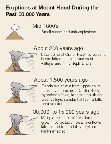
Mount Hood is more than 500,000 years old. The volcano has grown in fits and starts, with decades to centuries of frequent eruptions separated by quiet periods lasting from centuries to more than 10,000 years. In the recent past, Mount Hood has had two significant eruptive periods, one about 1,500 years ago and the other about 200 years ago.
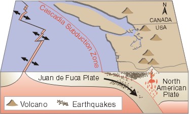 |
Subduction of the Juan de Fuca Plate under the North American Plate controls the distribution of earthquakes and volcanoes in the Pacific Northwest. Mount Hood is just one of several recently active, major volcanic centers in the Cascade Range. |
Unlike its neighbor to the north, Mount St. Helens, Mount Hood does not have a history of violent explosive eruptions. Instead, lava flows (see Volcano Hazards graphic for definitions of bold terms), rarely traveling more than 6 to 8 miles from their source, have built up the flanks of the volcano one sector at a time. Sometimes, instead of flowing slowly downhill, lava piles up over its vent forming a lava dome many hundreds of feet high. On the steep upper slopes of Mount Hood, growing lava domes have repeatedly collapsed to form extremely hot, fast-moving pyroclastic flows. Few of these pyroclastic flows have traveled more than 8 miles. But because they are extremely hot, such flows can melt significant quantities of snow and ice to produce lahars that flow down river valleys, often far beyond the flanks of the volcano. Over the past 30,000 years, growth and collapse of lava domes and generation of lahars have dominated Mount Hood's eruptive activity.
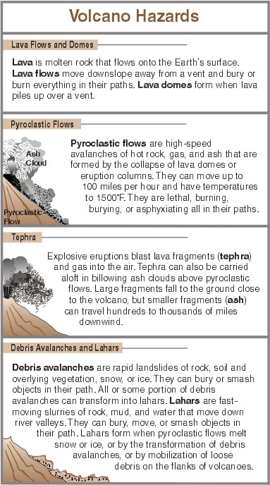 |
Throughout Mount Hood's history, rapid landslides, called debris avalanches, of various sizes have occurred. The largest ones removed the summit and sizable parts of the volcano's flanks and formed lahars that flowed to the Columbia River. Large debris avalanches occur infrequently and are usually triggered by eruptive activity. But small ones not associated with eruptive activity occur more frequently. Small avalanches can occur when rocks, altered and weakened by acidic volcanic fluids or by weathering, such as freezing and thawing, fail spontaneously.
 |
|
A River Transformed In 1806, Meriwether Lewis and William Clark named a river on the south side of the Columbia River gorge the “Quicksand River.” Their description of a wide, shallow river with a bed “formed entirely of quicksand,” bears little resemblance to the narrow, moderately deep river we call today the Sandy River. What happened? The answer lay 50 miles away at Mount Hood. An eruption in the 1790's caused a tremendous amount of volcanic rock and sand to enter the Sandy River drainage. That sediment was still being flushed downstream when Lewis and Clark saw and named the river. Since 1806, the river has removed the excess sediment from its channel. The Toutle River in southwest Washington was similarly affected by the 1980 eruptions of Mount St. Helens. A sediment-retention dam was built in the late 1980's to trap sediment and ease flooding in the lower Toutle River below the dam. |
Lahars are often associated with eruptive activity, but they can also be generated by rapid erosion of loose rock during heavy rains or by sudden outbursts of glacial water. On Christmas Day 1980, an intense rainstorm rapidly melted snow and triggered a small landslide in fragmental debris in upper Polallie Creek. The resulting lahar moved downvalley at 25 to 35 miles per hour. At the mouth of Polallie Creek, the lahar spread out, killing a camper and temporarily damming the East Fork Hood River. Flooding after failure of this temporary dam destroyed 5 miles of highway, three bridges, and a state park—at a cost of at least $13 million. Small lahars such as this occur every few years at Mount Hood, but few have been as destructive.
Two past eruptions at Mount Hood provide perspective on the impact of future large events. Both were associated with eruptive activity that triggered debris avalanches and were accompanied by lava extrusion, pyroclastic flows, and lahars. One represents a truly catastrophic event.
About 100,000 years ago, a large portion of the volcano's north flank and summit collapsed. The resulting debris avalanche transformed into a lahar that swept down the Hood River valley. At the river's mouth, where the town of Hood River now stands, the lahar was 400 feet deep. The lahar crossed the Columbia River and surged up the White Salmon River valley on the Washington side. Since that time lava has filled in the scar left by the debris avalanche.
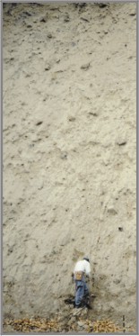 |
Geologist examining 100,000-year-old lahar deposit exposed along Underwood Hill Road, near the mouth of the White Salmon River in Washington. The lahar, derived from a large debris avalanche off the north side of Mount Hood, flowed down the Hood River, crossed the Columbia River, and traveled several miles up the White Salmon River before stopping. Here, the deposit is about 40 feet thick and about 300 feet above present river level. (Photo by William Scott, USGS) |
On the south side of the volcano, the scar from a 1,500-year-old debris avalanche is still visible, forming the amphitheater around Crater Rock. A lahar formed by this event traveled the length of the Sandy River valley, depositing boulders as large as 8 feet in diameter, 30 feet above present river level where the towns of Wemme and Wildwood now stand. The lahar spread out over the delta at the mouth of the Sandy River and pushed the Columbia River to the north. This event, although large by Mount Hood's standards, was only about one-tenth the size of the 100,000-year-old event.
Mount Hood's next eruption is much more likely to be smaller than or similar in size to the 1,500-year-old event. An eruption similar in size to the 100,000-year-old event, although possible, is much less likely.
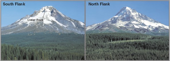 |
| The two faces of Mount Hood. In the photo of the south flank taken from Trillium Lake, the dashed line marks the steep scarp above Crater Rock formed by a landslide 1,500 years ago. Dome growth and collapse from Crater Rock during the last two eruptive episodes (1,500 and 200 years ago) sent numerous pyroclastic flows down the south flank, resulting in the smooth south-facing slope. On the north flank, lack of recent volcanic activity has preserved the deeply carved glacial landscape on this side of the mountain. In its long history, Mount Hood has experienced numerous ice ages, each lasting for thousands of years, when glaciers were more extensive than today. During the last one, which ended about 15,000 years ago, glaciers extended 4 to 5 miles beyond their present limits. (Photos by William Scott, USGS) |
Today Mount Hood shows no signs of imminent volcanic activity, but hot steam vents, or fumaroles, near Crater Rock attest to heat below. On clear, cold, windless days, a steam plume is often seen rising from the fumaroles. Visitors to Mount Hood frequently smell the "rotten egg" odor of the fumarole gas, whose composition indicates that magma lies a few miles below the summit.
Scientists expect the next eruption to consist of small explosions and the growth and collapse of lava domes, generating pyroclastic flows, ash clouds, and lahars. Lahars pose the greatest hazard because more people live downstream in lahar-prone river valleys than live on the volcano's flanks. Thus, it is important to know where one lives, works, and plays in relation to Mount Hood's hazard zones.
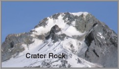 |
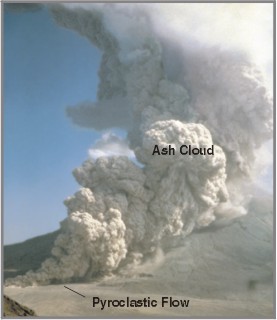
Mount Hood�s last major eruption occurred 200 years ago and consisted of growth and collapse of a lava dome that sent numerous pyroclastic flows down the south and west flanks. Crater Rock (above) is the remnant of that dome. The left photo shows a pyroclastic flow during the August 7, 1980, eruption of Mount St. Helens. A billowing ash cloud rises from the pyroclastic flow. Future pyroclastic flows from Mount Hood could devastate areas on the flanks of the volcano, and fallout of ash from the ash cloud could disrupt transportation and prove a nuisance to residents downwind. (Photos by Peter Lipman and David Wieprecht, USGS) |
 |
 |
|
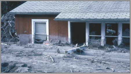
House partly buried by lahars from the 1980 eruption of Mount St. Helens. Note the high mud line on the house and large amounts of woody debris carried by the lahars. (Photo by Lyn Topinka, USGS) |
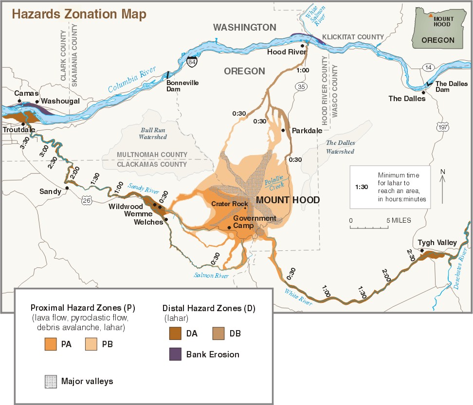
Hazard zones shown on the map were determined on the basis of distance from the volcano, vent location, and type of hazardous events. Proximal hazard zones (P) are areas subject to rapidly moving debris avalanches, pyroclastic flows, and lahars that can reach the hazard boundary in less than 30 minutes, as well as to slow-moving lava flows. Areas within proximal hazard zones should be evacuated before an eruption begins, because there is little time to get people out of harm's way once an eruption starts. Most pyroclastic flows, lava flows, and debris avalanches will stop within the proximal hazard zone, but lahars can travel much farther.
Distal hazard zones (D) are areas adjacent to rivers that are pathways for lahars. Estimated travel time for lahars to reach these zones is more than 30 minutes, which may allow individuals time to move to higher ground and greater safety if given warning. Shown are inundation areas for lahars of a size similar to lahars that swept through the Sandy River 1,500 year ago. Smaller or larger lahars will affect smaller or larger areas, respectively. Lahars could affect transportation corridors by damaging or destroying bridges and roads. Water from the Bull Run Watershed, vital to Portland, is transported in pipes that cross distal hazard zones along the Sandy River.
Proximal and distal hazard zones are subdivided into zones A and B on the basis of the vent location during the next eruption. During the past two eruptive episodes, the vent was located near Crater Rock. Scientists anticipate that the vent for the next eruption will most likely be in the same area. Thus, areas within hazard zones PA and DA have a higher probability of being affected during the next eruption than do areas within hazard zones PB and DB, which reflect a vent located on the volcano's west, north, or east flank.
During and after an eruption, large amounts of sediment could be carried by rivers and discharged into the Columbia River. This sediment could narrow the Columbia's channel, forcing it to the north and potentially causing bank erosion along the river's north bank.
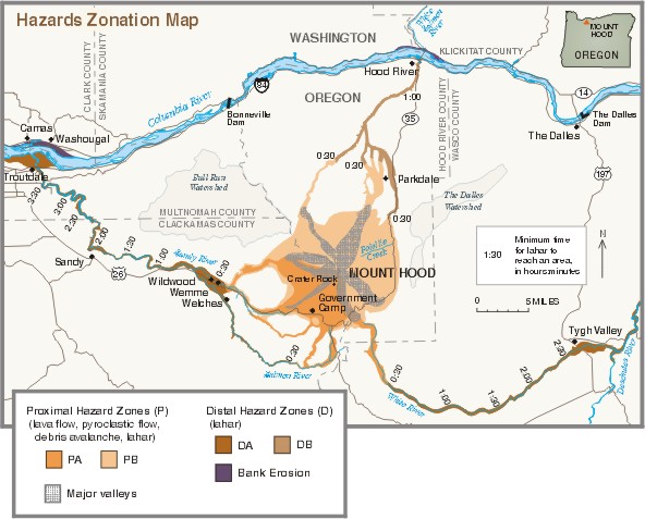 |
| Simplified volcano-hazards-zonation map for Mount Hood, Oregon. For more information on hazard zones see text or for a more detailed map and description see Scott and others, 1997, Volcano Hazards in the Mount Hood Region, Oregon, U.S. Geological Survey Open-File Report 97-89. |
Mount Hood does not have a history of large explosive eruptions. Therefore, it is unlikely that communities downwind (typically east of the volcano) will receive tephra accumulations thick enough to collapse roofs. However, even minor amounts of tephra can damage machinery and electronic equipment or make driving hazardous. Ash clouds from small explosions or from pyroclastic flows can reach tens of thousands of feet in altitude, endangering jet aircraft by causing engine failure. Minor amounts of tephra can make breathing difficult for those with respiratory problems, the elderly, and infants. For most residents, however, tephra will be a nuisance and can be mitigated by such actions as shutting down and covering equipment, frequently replacing air filters in machinery, wearing dust masks, and avoiding unnecessary travel.
Renewed activity at most volcanoes begins with increasing numbers of earthquakes beneath the volcano as magma moves towards the surface. Since 1977 the University of Washington's Geophysics Program and the USGS have continuously monitored earthquakes at Mount Hood. Typically, one to three small earthquake swarms (tens to more than one hundred earthquakes lasting 2 to 5 days) occur every year. What scientists are looking for as a sign of renewed activity is for a swarm to persist, for the number of earthquakes to increase dramatically, or for the depths of earthquakes to become shallower. Such signs of reawakening might also be accompanied by changes in composition or temperature of fumarole gases, or by deformation of the volcano's flanks.
Scientists can generally detect when a volcano becomes "restless," thereby providing some warning to officials and the public. But they cannot say precisely when an eruption will begin, how big it will be, or how long it will last. Thus, we will all have to confront many uncertainties when Mount Hood reawakens. Recent eruptions around the world reveal that lava-dome eruptions, like those typical of Mount Hood, can begin after weeks to months of restlessness, last for time periods of months to years, and generate tens to hundreds of pyroclastic flows and lahars of varying size. Unfortunately, the end of an eruption doesn't always mean the end of eruption-related problems. New deposits of rock debris on the volcano's slopes and in river valleys can be reworked to form lahars for many years after an eruption ends.
Scientists do not know when Mount Hood will erupt again or whether it will erupt in our lifetimes, but, as Mount St. Helens taught us, it is best to be prepared. Scientists continuously monitor Mount Hood for signs of unrest and are in communication with responsible local, State, and Federal agencies. Individuals too can prepare by doing the following:
A few moments spent now could help keep the next eruption of Mount Hood from becoming a disaster for you, your family, and your community.
Cynthia A. Gardner, William E. Scott, Jon J. Major, and Thomas C. Pierson
Graphics by Bobbie Myers, Lisa Faust, and Christine Janda; Web layout by Carolyn Donlin
For more information or copies of the paper version of this fact sheet contact:
U.S. Geological Survey
David A. Johnston Cascades Volcano Observatory
5400 MacArthur Blvd., Vancouver, WA 98661
Tel: (360) 993-8900, Fax: (360) 993-8980
e-mail: cvo@usgs.gov
Also, visit the Cascades Volcano Observatory on the Web.
COOPERATING ORGANIZATIONS
U.S Department of Agriculture, Forest Service
University of Washington, Geophysics Program
Related Fact Sheets and Open-File Reports
Living With Volcanic Risk in the Cascades
Volcano Hazards in the Mount Hood Region, Oregon
See a list of other volcano-related fact sheets published by the U.S. Geological SurveyPDF version of this fact sheet
U.S. GEOLOGICAL SURVEY–REDUCING THE RISK FROM VOLCANO HAZARDS
Learn more about
volcanoes and the hazards they pose at the
USGS
Volcano Hazards Program website