U.S. Geological Survey Fact Sheet 064-02
Online Version 1.0
U.S. Geological Survey
Fact Sheet 064-02
Online Version 1.0
The Kamchatkan Volcanic Eruption Response Team (KVERT)
|
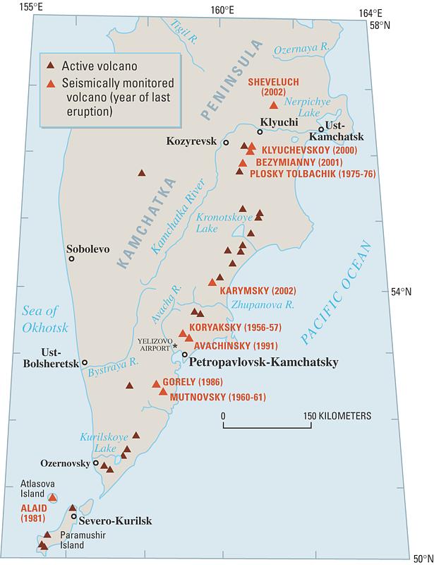
Russia's Kamchatka Peninsula is home to 29 active volcanoes, including 7 snow-capped stratocones more than 10,000 ft (3,000 m) high. Several eruptions each year in Kamchatka produce ash clouds that threaten the safety of air travel across the North Pacific, including travel between the United States and Russia and Japan. The Kamchatkan Volcanic Eruption Response Team (KVERT), created in 1993 through a cooperative effort of Russian and U.S. scientists, monitors the volcanoes of Kamchatka to provide warnings and rapid reporting of eruptions. |
|
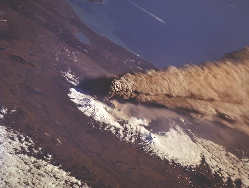
| In October 1994, Klyuchevskoy Volcano in northern Kamchatka erupted explosively, sending a column of volcanic ash more than 9 miles (15 km) into the air. This photograph taken from a space shuttle shows the ash cloud as high winds blow it southeastward over the North Pacific Ocean. The cloud crossed busy air routes in both Russian and U.S. airspace. Warnings from the Kamchatkan Volcanic Eruption Response Team (KVERT) were crucial to enabling the safe rerouting of North Pacific air traffic until the threat subsided. (Photograph courtesy of NASA.) |
Russia's Kamchatka Peninsula, across the Bering Sea from Alaska, has 29 active volcanoes. Although only a few of these pose a direct threat to the peninsula's sparse population, an eruption from any of them can be a serious threat to aviation throughout the entire North Pacific region. In a typical year, 3 or 4 explosive eruptions in Kamchatka send tiny jagged particles of rock and glass (volcanic ash) high into the atmosphere and across heavily traveled international air routes between Asia and North America.
Volcanic ash is extremely hazardous to flying jet aircraft. Encounters with ash clouds can cause jet engines to fail suddenly, because ash can erode compressor blades and melt and solidify onto moving parts. Ash clouds can drift with prevailing winds for many days and thousands of miles and still be a hazard to aircraft. Worldwide, more than 100 jet aircraft in the past 20 years have inadvertently entered ash clouds, causing hundreds of millions of dollars in damage. Although no fatal incidents have yet occurred, many encounters have been close calls.
The threat of volcanic ash to aircraft can be reduced through warnings of eruptions, timely detection and tracking of ash clouds, and effective communication of the hazard to authorities and the aviation community. In 1993, recognizing the need for rapid detection of volcanic eruptions occurring in the northwest Pacific, scientists with the Russian Academy of Sciences Institute of Volcanic Geology and Geochemistry (IVGG) and the Kamchatkan Experimental and Methodical Seismological Department (KEMSD) created the Kamchatkan Volcanic Eruption Response Team (KVERT). This was done in close collaboration with the Alaska Volcano Observatory (AVO), a cooperative effort of the U.S. Geological Survey (USGS), University of Alaska Fairbanks Geophysical Institute, and Alaska Division of Geological and Geophysical Surveys. Funding for KVERT and its staff of about a dozen full- and part-time scientists has been provided by several organizations, including the International Air Transport Association, U.S. Agency for International Development, USGS, and the Russian State Unitary Enterprise Kamchatkaeronavigatziya.
|
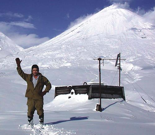
The most effective method of detecting unrest at volcanoes is seismic (earthquake) monitoring. As of 2002, 27 remote seismic monitoring stations are operating at 9 of the most active volcanoes in Kamchatka and at Alaid Volcano, on Paramushir Island in the northern Kurile Islands. Direct visual observations are also important in confirming volcanic eruptions and making hazard assessments. They allow scientists to calibrate seismic data in order to remotely interpret volcanic activity. KVERT scientists have developed methods of estimating eruption plume height from the intensity of seismicity. This is an important tool in Kamchatka, where many volcanoes are remote and frequently obscured by clouds. Analysis of satellite imagery is another powerful technique used to detect volcanic eruptions and track the movements of ash clouds.
|
|
|
Seismic monitoring station at base of Klyuchevskoy Volcano, Russia. |
KVERT provides frequent status reports and notices of volcanic activity in Kamchatka, by telephone and over the Internet, to local authorities and through them and AVO to the international community. The level of hazard at Kamchatkan volcanoes is communicated using a four-color code similar to that developed by AVO for Alaskan volcanoes. When eruptive activity is observed, KVERT uses an emergency call-down procedure to notify the Airport Meteorological Center (AMC) at Yelizovo Airport in Petropavlovsk-Kamchatsky, the Kamchatka Department of Civil Emergency, AVO, and local media and officials. The Yelizovo Airport AMC is responsible for then notifying the Tokyo Volcanic Ash Advisory Center, which in turn issues Volcanic Ash Advisory Statements to the aviation community.
A written description of each eruption is also sent from KVERT to AVO, which then distributes it to more than 200 users by phone, fax, and the Internet. If KVERT reports an eruption with potential impacts to U.S. airspace, AVO directly notifies the National Weather Service, the Federal Aviation Administration, and other U.S. agencies.
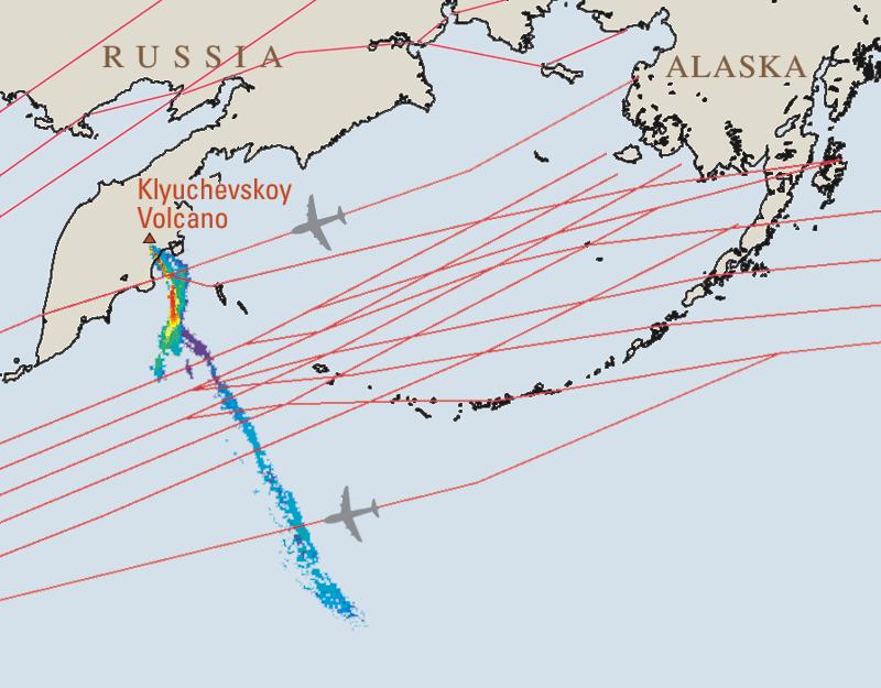
A volcano crisis that demonstrated KVERT's value was the 1994 eruption of Klyuchevskoy Volcano in northern Kamchatka. On October 1st, after 3 weeks of low-level eruptive activity tracked and reported by KVERT, an explosive eruption blasted an ash column to a height of more than 49,000 ft (15 km). Winds of 150 mph (240 km/h) blew the ash cloud southeastward more than 620 mi (1,000 km) over the Pacific Ocean at altitudes of 31,000 to 38,000 ft (9,500 to 11,500 m), sweeping it across vital air routes in both Russian and U.S. airspace. Within 2 hours of the climactic eruption and of a subsequent series of ash explosions, KVERT and AVO had notified aviation authorities and air carriers. These warnings, along with guidance from the National Oceanic and Atmospheric Administration (NOAA) on expected movement of ash clouds, enabled dispatchers and air-traffic controllers to safely reroute North Pacific air traffic until the threat subsided.
Since KVERT issued its first information release on the status of Kamchatkan volcanoes, in March 1993, more than 500 information releases and dozens of eruption notifications have been distributed to passenger and cargo airlines, emergency management agencies in the U.S. and Russia, the media, and scientists around the world. KVERT's prompt and reliable reporting has helped ensure that aircraft can safely and efficiently avoid dangerous ash clouds.
In coming decades, air traffic in the North Pacific is projected to increase steadily. The risk of costly, damaging, and possibly deadly encounters of aircraft with volcanic ash clouds will rise accordingly, underscoring the importance of KVERT operations to the safety of air travel in this volcanically active region. To meet this challenge, KVERT and its partners, including USGS, are working to expand monitoring and warning capacity by adding more seismic networks and video systems and by enhancing satellite analysis for Kamchatka and the adjacent Kurile Islands.
Vladimir Yu. Kirianov, Christina A. Neal, Evgenii I. Gordeev, and Thomas P. Miller
Edited By
James W. Hendley II and Peter Stauffer
Graphic Design By
Susan Mayfield and Sara Boore; Web layout by Carolyn Donlin
Banner Design By
Bobbie Myers
COOPERATING
ORGANIZATIONS
Airline Pilots Association
Alaska Division of Geological and Geophysical Surveys
Federal Aviation Administration
Geophysical Institute University of Alaska Fairbanks
Institute of Volcanic Geology and Geochemistry, Russian Academy of Sciences
International Air Transport Association
International Civil Aviation Organization
Kamchatkan Experimental and Methodical Seismological
Department, Geophysical Service, Russian Academy of Sciences
National Oceanic and Atmospheric Administration/National
Environmental Satellite Data and Information Service/Satellite Services Division
National Weather Service/Anchorage Volcanic Ash Advisory Center
State Unitary Enterprise Kamchatkaeronavigatziya
Tokyo Volcanic Ash Advisory Center, Japan Meteorological Agency
U.S. Agency for International Development
Yelizovo Airport Meteorological Center
For more information contact:
Alaska Volcano
Observatory or http://www.kcs.iks.ru/ivgig/ Related Fact Sheets Volcanic
Ash—Danger to Aircraft in the North Pacific (USGS Fact Sheet 030-97) Volcanic Ash
Fall—A "Hard Rain" of Abrasive Particles (USGS Fact Sheet 027-00)
4200 University Drive
Anchorage, AK 99508
(907) 786-7497
http://www.avo.alaska.edu
http://data.emsd.iks.ru/video/video.htm
http://emsd.iks.ru/~ssl/
http://volcanoes.usgs.gov/
PDF version of this fact sheet (448 KB)
Russian-language version available as a PDF file (448 KB)
Download a free copy of Adobe Acrobat Reader
U.S. GEOLOGICAL SURVEY–REDUCING THE RISK FROM VOLCANO HAZARDS
Learn more about volcanoes
and the hazards they pose at the USGS Volcano
Hazards Program Website or the Alaska
Volcano Observatory Website
For questions about the content of this fact sheet, contact Tina Neal
URL of this page:
https://pubs.usgs.gov/fs/2002/fs064-02/
Maintained by: Michael Diggles
Created: September 25, 2002
Last modified: May 17, 2005 (mfd)