
U.S. Geological Survey
Fact Sheet 086-02
| Millions of southern Californians depend on ground water from the Los Angeles Basin. The U.S. Geological Survey (USGS) is working with local water-management agencies to gain a better understanding of ground-water flow within the basin and to create an improved model of the sediment layers below its surface. These efforts are providing crucial information for managing and ensuring the sustainability of the region’s ground-water supply. The data obtained are also being used to help locate areas especially susceptible to earthquake shaking. |
More than 10 million people live in the Greater Los Angeles metropolitan area. Much of this population depends on water pumped from beneath the surface of the Los Angeles Basin. For example, one-third of the water consumed by the 4 million residents in the central and west coast basins is ground water. Successful management of this ground-water resource requires knowing where and how fast the water moves in the various layers of sediment that fill the basin.
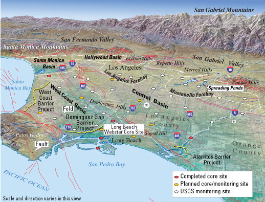 |
| Greater Los Angeles depends on ground water for much of its water supply. As part of a cooperative project with local water-management agencies to better understand the ground-water system and geology of the Los Angeles Basin, the U.S. Geological Survey has drilled more than 30 monitoring wells. Critical issues being examined include the transport and fate of recharge water infiltrated into the ground-water system from spreading ponds in the Montebello Forebay (an area where surface water easily infiltrates the ground) and saltwater intrusion into freshwater aquifers along the coast. In an effort to halt saltwater intrusion, barriers (yellow lines) consisting of arrays of freshwater injection wells have been installed by local water-management agencies. |
Since 1995, the U.S.
Geological Survey (USGS) has been working with the Water Replenishment District
of Southern California in a cooperative ground-water and geologic study of the
Los Angeles Basin. Now, with additional support from the Los Angeles County
Department of Public Works, the USGS is expanding this program to study the
distribution and geologic history of sediments as deep as 1,500 feet (450 meters)
below city streets. This information is critical not only to ground-water management
but also to earthquake hazard assessment in the densely populated region. During
a strong earthquake, ground shaking may cause water-saturated sediment to “liquefy,”
resulting in ground failure. Therefore, knowing the composition of near-surface
sediment is important for assessing the vulnerability of buildings to liquefaction
and other damaging effects of earthquakes.
The USGS has already drilled
more than 30 monitoring wells throughout the Los Angeles Basin and has collected
chemical, geologic, hydrologic, and geophysical data from these and other wells
in the region. One critical issue being examined is seawater intrusion into
freshwater aquifers along the coastal parts of the basin. Another such issue
is the transport and fate of water diverted into spreading ponds in the Montebello
Forebay, an area of the basin where the underlying sediment is relatively coarse
and clay poor and so allows surface water to infiltrate into and recharge the
ground-water system.
Ideally, when the monitoring
wells are drilled in the Los Angeles Basin, attempts are made to recover intact
sediment cores from the full length of a well. Because drilling is costly, large
parts of the basin must be explored by other means. Geophysical techniques,
such as seismic imaging and gravity surveys, are used to interpolate the character
of sediments between wells. Geologic mapping of surface deposits in the basin
provides clues to what lies beneath. In harbors and offshore areas, geologic
structure below the water surface is revealed by using a ship-towed system that
probes the sediments with acoustic pulses. The data obtained using this range
of techniques help to characterize the three-dimensional geologic structure
and ground-water flow system of the basin.
The present distribution of gravel, sand, and clay in the Los Angeles Basin reflects the interplay between the seashore processes and streams carrying sediment from the upland areas surrounding the basin. Similar processes operated in the past; therefore, knowing the geologic history of changes in sea-level, climate, and rivers allows prediction of the distribution of subsurface sediments in the basin and their possible effects on the regional ground-water flow and seismic hazards.
In the cores recovered in
the Los Angeles Basin so far, several past cycles of advance and retreat of
the sea have been identified. Each cycle leaves a signature in the sediments
by producing distinctive layering or bedding, evidence of erosion, and telltale
assemblages of fossils. Preliminary age determinations of core samples indicate
a correlation of these cycles with the sea-level changes that occurred in the
past as a result of the storing and release of vast quantities of water during
alternating glacial periods (“ice ages”) and intervening warm periods.
 |
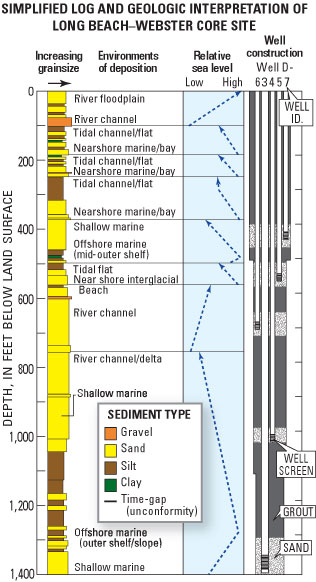 |
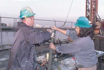
| Sediment cores collected during the drilling of monitoring wells by the U.S. Geological Survey (USGS) in the Los Angeles Basin (see photo) provide information that is vital to understanding ground-water flow and seismic hazards in the region. Scientists study and sample the cores in a USGS mobile laboratory. This diagram shows various types of information obtained from study of cores from a single well. Shown are the thickness and grain size of sediment layers down the length of the well; environments of deposition, such as river channels and tidal flats, interpreted from fossils and other features; changing trends of the height of the depositional surface relative to sea level (blue dashed arrows), and location of well screens that enable sampling of water-bearing layers. |
An example of how sediments
can be interpreted to reveal past conditions was provided during recent drilling
of a USGS water-monitoring well in the City of Long Beach. Shells and thick
pieces of wood were discovered in coarse sand at a depth of 400 feet (120 meters).
This sediment layer, although found hundreds of feet below the surface and several
miles inland from the present shoreline, is an ancient beach deposit and has
been dated at about 300,000 years old. This date correlates to a high stand
of sea level during a warm period between ice ages. The ancient beach is now
well below the current ground surface because the Los Angeles Basin has subsided
with time as it filled with sediment.
Much information has already
been collected in the ongoing study of the Los Angeles Basin. To evaluate the
potential effects of alternative strategies for water management, USGS scientists
are using these data to develop a computer simulation of ground-water flow in
the basin. In addition, to further evaluate the ground-water resource, as well
as earthquake hazards, the scientists are using the data to develop a model
of the three-dimensional geology of the basin. This model includes ages, thicknesses,
grain sizes, and environments of deposition of sedimentary beds; locations and
quality of water-bearing zones; and locations of major fractures and faults.
This geologic model will incorporate the concept of “sequence stratigraphy,”
which recognizes the influence of climate-driven depositional cycles on the
distribution of sediment types.
During the next several years, the USGS will be drilling and coring more wells in the Los Angeles Basin and applying geologic and ground-water models to address a host of practical questions for the region: What are the main pathways for seawater intrusion? What are the best strategies for recharging the ground-water supply, such as pumping, injecting, and spreading water? Where are faults located underground and what earthquake hazards do they pose? Which areas face greater risks to life and property during earthquakes because they are more likely to experience intensified shaking or soil liquefaction?
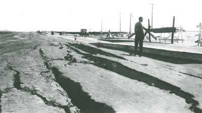 |
| During earthquakes, ground shaking may cause water-saturated sediment to “liquefy,” resulting in ground failure. In the 1933 Long Beach earthquake, liquefaction of the underlying soil damaged this section of the Pacific coast highway south of Los Angeles (photo courtesy City of Long Beach Public Library History Collection). In the 1994 Northridge earthquake, liquefaction also caused considerable damage in the Los Angeles Basin. Data being obtained by the U.S. Geological Survey on the distribution and character of near-surface sediments in the basin are providing information that is crucial to evaluating local susceptibility to earthquake damage caused by liquefaction and other forms of ground failure. |
The cooperative efforts
of the USGS, the Water Replenishment District of Southern California, and the
Los Angeles County Department of Public Works are providing a better understanding
of the ground-water system and geology of the Los Angeles Basin. This knowledge
is essential to ensuring future adequate ground-water supplies for this populous
urban region and to mitigating the threat posed by earthquakes.
By John W. Hillhouse,
Eric G. Reichard, and Daniel J. Ponti
Edited by James W. Hendley
II and Peter H. Stauffer
Graphic design by Susan Mayfield, Rudolph Contreras, and Sara Boore; Web layout by Carolyn Donlin
COOPERATING ORGANIZATIONS
Water Replenishment District of Southern California
Los Angeles County Department of Public Works
For more information contact:
Ground Water – Eric Reichard (858)
637-6834
U.S. Geological Survey
5735 Kearny Villa Road
San Diego, CA 92123
Earthquake Hazards –
Daniel Ponti (650) 329-5679
U.S. Geological Survey MS 977
345 Middlefield Rd.
Menlo Park, CA 94025
See also Saltwater Intrusion in Los Angeles Area Coastal Aquifers—The Marine Connection (USGS Fact Sheet 030-02)
PDF version of this fact sheet (480 KB)
Download a copy of Adobe Reader for free
| Help | PDF help | Geopubs main page | Fact Sheets |
| Department
of the Interior | Privacy Statement
| Disclaimer | Accessibility
|
URL of this
page: https://pubs.usgs.gov/fs/2002/fs086-02/
Maintained by: Michael Diggles
Created: October 18, 2002
Last modified: September 15, 2006 (mfd)