
U.S. Geological Survey Fact Sheet 092-02
Online Version 1.0
U.S.
Geological Survey Fact Sheet 092-02
Online Version 1.0
Mount Mazama and Crater Lake: Growth and Destruction of a Cascade Volcano
| For more than 100 years, scientists have sought to unravel the remarkable story of Crater Lake’s formation. Before Crater Lake came into existence, a cluster of volcanoes dominated the landscape. This cluster, called Mount Mazama (for the Portland, Oregon, climbing club the Mazamas), was destroyed during an enormous explosive eruption 7,700 years ago. So much molten rock was expelled that the summit area collapsed during the eruption to form a large volcanic depression, or caldera. Subsequent smaller eruptions occurred as water began to fill the caldera to eventually form the deepest lake in the United States. Decades of detailed scientific studies of Mount Mazama and new maps of the floor of Crater Lake reveal stunning details of the volcano’s eruptive history and identify potential hazards from future eruptions and earthquakes. |
|
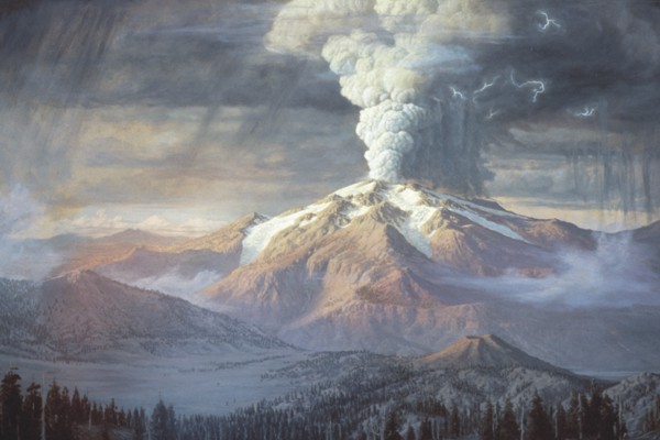
| The cataclysmic eruption of Mount Mazama 7,700 years ago began with a towering column of pumice and ash, as depicted in this painting by Paul Rockwood (image courtesy of National Park Service, Crater Lake National Park Museum and Archive Collections). |
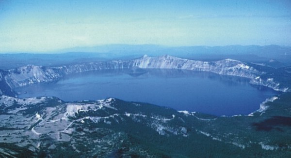 |
| After the collapse of the summit of the volcano, the caldera filled with water to form Crater Lake (Photo by Willie Scott, USGS). |
When Clarence Dutton of the U.S. Geological Survey (USGS) visited Crater Lake, Oregon in 1886, he was awestruck by its amazing beauty: “as the visitor reaches the brink of the cliff, he suddenly sees below him an expanse of ultramarine blue of a richness and intensity which he has probably never seen before, and will not be likely to see again.” He spent nearly a month sounding the depths of the lake from a rowboat, wondering at the forces that could create such a magnificent landscape. In the more than 100 years since Dutton’s first survey, scientists have steadily unraveled the mystery of the formation of Crater Lake and with it the demise of Mount Mazama.
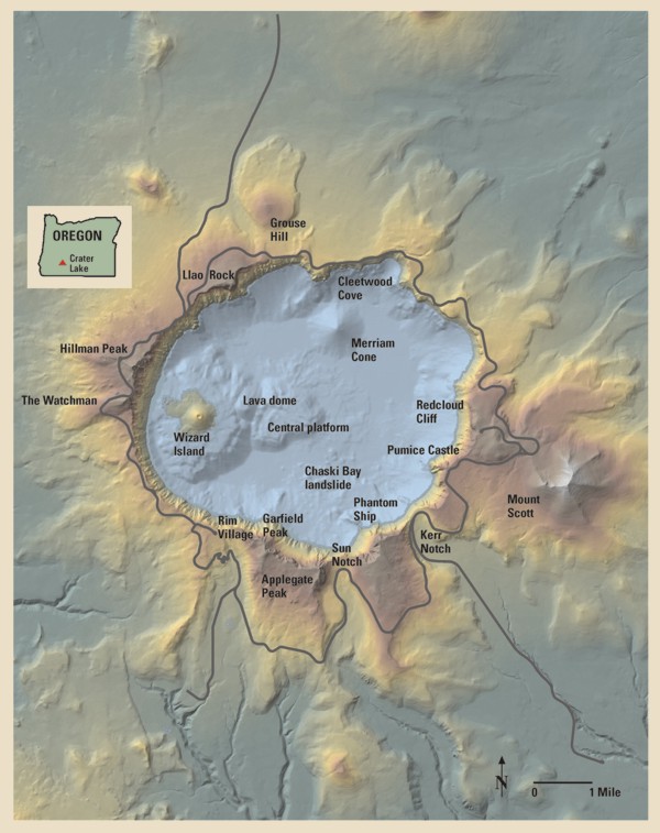
Mount Mazama
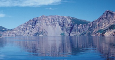
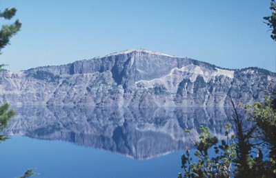
Mount Mazama was formed over a period of nearly half a million years by a succession of overlapping volcanoes. The first eruptions about 420,000 years ago built Mount Scott, located just east of Crater Lake. Over the next several hundred thousand years, Mount Scott and other nearby volcanoes became extinct, while new volcanoes grew to the west. Layers of lava flows from these volcanoes are visible in the caldera walls and in landmarks along the south rim of Crater Lake, including Applegate and Garfield Peaks. During the growth of Mount Mazama, glaciers repeatedly carved out classic U-shaped valleys. Some were filled with lava from later eruptions, while others, such as Kerr Notch and Sun Notch, were not.
By about 30,000 years ago, Mount Mazama began to generate increasingly explosive eruptions that were followed by thick flows of silica-rich lava, an outward sign of the slow accumulation of a large volume of highly explosive magma deep beneath the volcano. Grouse Hill and Redcloud Cliff are thick lava flows erupted between 30,000 and 25,000 years ago. Another such eruption about 7,900 years ago formed a white layer of pumice and ash and the thick lava flow of Llao Rock. Within 200 years of the eruption at Llao Rock, another thick lava flow erupted near present-day Cleetwood Cove. These eruptions reached a peak 7,700 years ago in the largest explosive eruption in the Cascades during the past 1 million years.
Crater Walls Tell the Story of Mount Mazama
 |
 |
The earliest eruptions about 420,000 years ago built Mount Scott (photo by Ed Klimasauskas, USGS). |
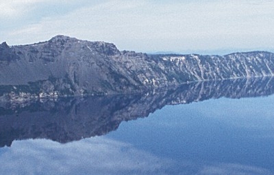 |
After the eruptions at Mount Scott, a series of successively younger overlapping volcanoes grew to the west. Landmarks along the south rim of Crater Lake caldera, such as Garfield Peak, are made up of lava flows erupted from these volcanoes over several hundred thousand years (photo by Ed Klimasauskas, USGS). |
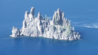 |
400,000 year-old lava flows make up Phantom Ship, the oldest rocks exposed above lake level within the caldera (photo by Ed Klimasauskas, USGS). |
 |
Glaciers carved classic U-shaped valleys on the flanks of Mount Mazama during ice ages, including the valleys of Sun Notch and Kerr Notch (photo by Ed Klimasauskas, USGS). |
 |
Beginning about 30,000 years ago, eruptions of a silica-rich magma called rhyodacite signaled the beginning of explosive eruptions that would lead to the cataclysmic eruption. During one such eruption about 7,900 years ago, the white layer of pumice and ash beneath Llao Rock was formed. After the explosive phase ended, the thick lava flow of Llao Rock oozed over the pumice and ash (photo by Ed Klimasauskas, USGS). |
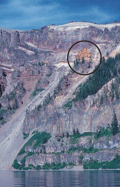 |
A thick layer of pumice and ash from the eruption that formed Crater Lake caldera blankets much of the caldera rim. Other layers of pumice and ash, like the orange Pumice Castle (circled), are deposits from older, smaller explosive eruptions (photo by Ed Klimasauskas, USGS). |
Mount Mazama’s Final Eruption
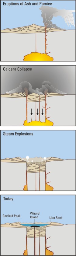
The cataclysmic eruption of Mount Mazama 7,700 years ago started from a single vent on the northeast side of the volcano as a towering column of pumice and ash that reached some 30 miles (50 km) high. Winds carried the ash across much of the Pacific Northwest and parts of southern Canada. So much magma erupted that the volcano began to collapse in on itself. As the summit collapsed, circular cracks opened up around the peak. More magma erupted through these cracks to race down the slopes as pyroclastic flows. Deposits from these flows partially filled the valleys around Mount Mazama with up to 300 feet (100 m) of pumice and ash. As more magma was erupted, the collapse progressed until the dust settled to reveal a volcanic depression, called a caldera, 5 miles (8 km) in diameter and one mile (1.6 km) deep.
Crater Lake
Soon after the cataclysmic eruption, eruptions from new vents within the caldera built the base of Wizard Island and the central platform. As eruptions continued, rain and snowmelt also began to fill the caldera. For the next few hundred years, eruptions from these new vents kept pace above the rising water level. Lava flowed into the deepening lake, creating benches on the flanks of the growing cones that tell scientists how deep the lake was during these eruptions. One set of eruptions from a crater on the west edge of the central platform formed lava tubes or channels that sent lava far out onto the caldera floor.
Later eruptions from a vent in the northern part of the caldera, just south of present-day Cleetwood Cove, built Merriam Cone. The erupting Merriam Cone probably never reached the lake surface. The ever-deepening lake eventually drowned the central platform volcano as well. Only Wizard Island managed to grow high enough to stay above the waterline. The last eruptions at Wizard Island took place when the lake was about 260 feet (80 m) lower than today. All of this activity occurred within 750 years after the cataclysmic eruption. The water level continued to rise until reaching near present-day levels, where it encountered a thick layer of porous deposits in the northeast caldera wall. These deposits stabilize lake levels like an overflow drain in a bathtub.
Sometime after these eruptions, the Chaski Bay landslide, the top of which is still visible above the southern shore of Crater Lake, slumped into the caldera and ran up onto the edge of the central platform. Other landslides within the caldera were deflected by the base of Wizard Island and the central platform, burying explosion craters and other features on the lake floor with even more debris.
The last known eruption at Crater Lake occurred when a small lava dome erupted under water on the east flank of the base of Wizard Island about 4,800 years ago. Since that time, the volcano has remained quiet, allowing as much as 100 feet (30 m) of sediment to accumulate on the lake bottom.
 |
Cataclysmic eruption to
present.
Eruptions of ash and pumice: The cataclysmic eruption started from a vent on the northeast side of the volcano as a towering column of ash, with pyroclastic flows spreading to the northeast. Caldera collapse: As more magma was erupted, cracks opened up around the summit, which began to collapse. Fountains of pumice and ash surrounded the collapsing summit, and pyroclastic flows raced down all sides of the volcano. Steam explosions: When the dust had settled, the new caldera was 5 miles (8 km) in diameter and 1 mile (1.6 km) deep. Ground water interacted with hot deposits causing explosions of steam and ash. Today: In the first few hundred years after the cataclysmic eruption, renewed eruptions built Wizard Island, Merriam Cone, and the central platform. Water filled the new caldera to form the deepest lake in the United States. Figure modified from diagrams on back of 1988 USGS map “Crater Lake National Park and Vicinity, Oregon.” |
The Future
The long history of volcanic activity at Crater Lake suggests strongly that this volcanic center will erupt again. The most recent eruptions occurred on the lake floor in the western part of the caldera. Future eruptions are more likely to occur in the same area than farther east. Interaction of magma and lake water at shallow levels (less than 100 feet or a few tens of meters) could generate explosions that throw large rocks and ash out beyond the caldera walls. The largest explosions could produce pyroclastic surges, hot, rapidly moving clouds of gas and ash, which could move out a few miles from vents along the margin of the lake. Eruptions in deeper water are less likely to be explosive or affect areas around the rim. An eruption similar to the one 7,700 years ago is unlikely because large volumes of magma are not available to cause such an eruption.
Landslides from the caldera walls can cause waves that flood shoreline areas, but one that could cause overtopping or failure of the caldera walls and catastrophic draining of Crater Lake is unlikely. At its lowest point, the caldera rim is more than 500 feet (165 m) above the lake level. Only major volcanic activity could cause the caldera walls to fail and result in flooding of lowland areas below Crater Lake.
Crater Lake lies within a region where the Earth’s crust is being gradually stretched. The faults that accommodate this extension could produce damaging earthquakes in Crater Lake National Park today. The West Klamath Lake fault zone consists of numerous faults, one of which passes 1/2 mile west of Rim Village. Although earthquakes as large as magnitude 7.0 are possible, scientists believe that they occur only about once every 3,000 to 10,000 years. Such earthquakes could cause landslides large enough to generate dangerous waves on Crater Lake. Smaller earthquakes are much more likely, but they are unlikely to trigger large landslides.
Probing the Depths
For more than 100 years, scientists have marveled at Crater Lake’s great depth and sought to unravel the mysteries hidden beneath its surface. Clarence Dutton of the USGS led the first expedition to determine the depth of the lake in 1886. With a lead weight and piano wire, Dutton’s party made 168 soundings from a rowboat and reported a maximum depth of 1,996 feet (608 m). The National Park Service made additional soundings of this type between 1938 and 1940.
It wasn’t until the advent of sonar that the nature of the caldera beneath the lake became clearer. In 1959, the US Coast and Geodetic Survey obtained more than 4,000 echo soundings and provided a more accurate estimate of the maximum depth of Crater Lake ö 1,932 feet (589 m). Contours of these data revealed the principal features on the floor of Crater Lake ö the central platform, Merriam Cone, a small lava dome on the east side of Wizard Island, and the Chaski Bay landslide ö for the first time. About the same time, Crater Lake ranger-naturalist C. Hans Nelson collected dredge samples that showed a variety of post-7,700-year eruptive activity. In 1979, Nelson returned to the lake as a USGS marine geologist and used acoustic imaging techniques (like making a CAT scan) of the lake floor to discover that as much as 250 feet (75 m) of sediment had accumulated since caldera collapse. Nelson’s study found that beneath the sediment were many depressions located along the caldera-collapse ring fractures. These crater-like structures were probably formed by steam explosions as water began to accumulate within the still-hot debris shortly after the cataclysmic eruption.
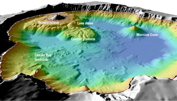 |
| Details of features beneath the surface of Crater Lake constructed using data from the 2000 bathymetry survey. Colors range from orange to blue with increasing water depth. |
A later USGS party mapped areas where large amounts of heat escaped from the lake floor. In 1988 and 1989, scientists from Oregon State University, the National Park Service, and the USGS explored parts of the lake floor with a manned submersible, paying special attention to the warm areas identified earlier. Several dives were devoted to exploring the volcanic features on the lake floor and to sampling caldera-wall outcrops. The exploration with the submersible suggested the need for remapping the lake floor with modern techniques to provide a bathymetric (depth) map for interpreting the postcaldera geologic history and as a base for further study of the lake itself.
The new bathymetric mapping was completed in the summer of 2000 by scientists from the USGS, the National Park Service, the University of New Hampshire, and C & C Technologies. Using a high-resolution acoustic mapping system mounted on a special boat, they collected millions of accurately located echo soundings during a 5-day survey. The information gained from this latest survey not only provided a new maximum depth for Crater Lake ö 1,949 feet (594 m) ö but also resulted in a detailed map of features on the lake floor. By combining the new bathymetric data with past decades of other research, scientists now have the clearest picture yet of events that happened since the massive eruption 7,700 years ago that destroyed Mount Mazama and created Crater Lake.
Ed Klimasauskas, Charles Bacon, and Jim Alexander
Graphics and layout by
Ed Klimasauskas, Bobbie Myers,
and Peter Dartnell
COOPERATING
ORGANIZATIONS
National Park Service
Oregon State University
University of New Hampshire
Crater Lake Natural History Association
For more
information contact:
U.S. Geological Survey
Cascades Volcano Observatory
1300 SE Cardinal Court, Bldg. 10, Suite 100
Vancouver, WA 98683-9589
Tel: (360) 993-8900, Fax: (360) 993-8980
http://vulcan.wr.usgs.gov/
or
USGS Volcano Hazards Program
http://volcanoes.usgs.gov/
or
USGS Crater Lake Data Clearing House
http://craterlake.wr.usgs.gov/
or
Crater Lake National Park
http://www.nps.gov/crla/
Related
Fact Sheets
What are
Volcano Hazards? (USGS Fact Sheet 002-97)
Volcanic Ash - A "Hard Rain" of Abrasive Particles
(USGS Fact Sheet 027-00)
See a list of other volcano-related Fact Sheets published by the U.S. Geological Survey
U.S. GEOLOGICAL SURVEY and the NATIONAL PARK SERVICE–OUR VOLCANIC PUBLIC LANDS
View or download this 4-page, full-color Fact Sheet as a PDF file (7 MB)
Download a copy of Acrobat Reader for free
For questions about the content of this fact sheet, contact Charlie Bacon
| Download help | PDF help | Fact Sheets |
| U.S. Department of the Interior | U.S. Geological Survey | Volcano Hazards Program |
| Privacy statement | Disclaimer | Accessibility |
URL of this page:
https://pubs.usgs.gov/fs/2002/fs092-02/
Maintained by: Michael Diggles
Created: September 27, 2002
Last modified: November 21, 2013 (dgf)