U.S. Geological Survey Fact Sheet 2004-3021
This fact sheet is available as a pdf.
Results of a U.S. Geological Survey study show that the drought of 1999-2002 was the most severe drought on Maine rivers in more than 50 years. The only comparable period of statewide drought was from 1947 to 1950. The drought during the 1960s was more noteworthy for its duration than its severity. Ground-water levels in 2001-2002 reached record lows in much of the State.
|
Dry conditions were widespread in Maine during 1999-2002, with a severe drought in 2001-2002 (fig. 1). These dry conditions were reflected in low stream-flow and ground-water levels. According to measurements by the U.S. Geological Survey (USGS), record lows were set at many streamflow-gaging stations and most monitoring wells in Maine during 1999-2002. This Fact Sheet summarizes information in the USGS report “Drought Conditions in Maine, 1999-2002: A Historical Perspective” (Lombard, 2004).
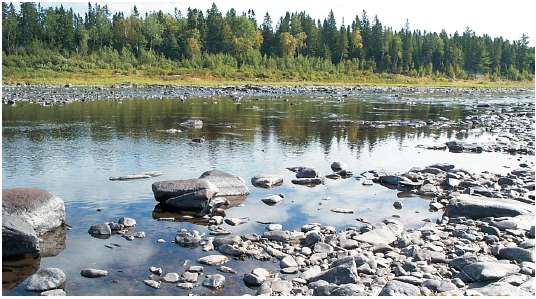 |
Figure 1. 100-yr drought on the St. John River at Ninemile, Maine (September 2002). |
Seven-day moving averages of daily streamflow from January 1999 to September 2002 were compared to 7-day moving average minimums, means, and maximums for the period of record at USGS stream- flow-gaging stations.
Northern Maine—In this area, the drought in 1999-2001 was not as extreme as it was in central Maine, but it became quite severe in 2002. The St. John River below Fish River at Fort Kent (USGS station 01014000) had record low 7-day streamflows in September 2002 (fig. 2).
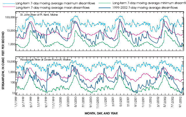 |
| Figure 2. Comparison of 1999-2002 streamflow to long-term streamflow at two U.S. Geological Survey streamflow-gaging stations. |
Central Maine—This area showed record low conditions during 1999-2002. The Piscataquis River near Dover-Foxcroft in central Maine (USGS station 01031500) recorded extremely low streamflow in the spring of 1999 and in the falls of 2001 and 2002 (fig. 3). The station had record low 7- day streamflows in April and May 1999, July through September 2001, and August and September 2002 (fig. 2). The drought continued to be severe in central Maine in 2002, but became less severe near the coast.
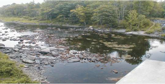 |
| Figure 3. 100-yr drought on the Piscataquis River near Dover-Foxcroft, Maine (August 2001). |
Southern Maine—Streamflow in this area was low during 2001 and 2002, but it was not as low as in other parts of the State.
At several USGS monitoring wells, month-end water levels from January 1999 to September 2002 were compared to long- term ground-water levels, including the month-end minimum, 25th percentile, median, 75th percentile, and maximum. In most cases, month-end ground-water levels were in the normal range (between the 25th and 75th percentiles) for most of 1999 and 2000, but were consistently below the normal range in 2001 and 2002.
Central Maine—A USGS monitoring well in Somerset County (SMW 61) had record low ground-water levels in May through August 1999, October 2001 through March 2002, and August 2002 through September 2002 (fig. 4). Levels were below normal throughout 2001 and 2002.
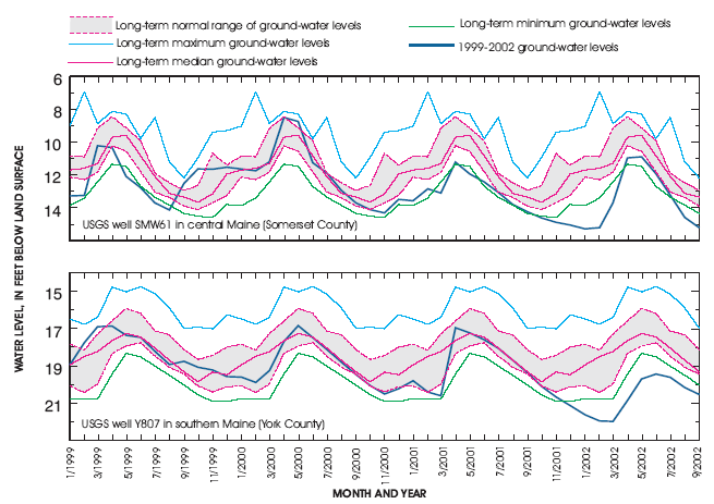 |
| Figure 4. Comparison of 1999-2002 month-end ground-water levels to long-term levels at two U.S. Geological Survey monitoring wells. |
Southern Maine—A USGS monitoring well in York County (Y807) had normal ground-water levels from the spring of 1999 through the fall of 2000. As drought conditions intensified, month-end ground-water levels declined to the lowest levels on record for every month from December 2001 through September 2002 (fig. 4).
Effect on People• Thirty-five public-water suppliers, including 8 large community
systems, were affected severely (Andrews Tolman, Maine Drinking Water
Program, written commun., • Approximately 17,000 private wells in Maine went dry in the 9 months prior to April 2002 (Maine Emergency Management Agency, 2002). • More than 32 million dollars was lost in crops in 2001 and 2002 and some growers of wild blueberries recorded crop losses of 80 to 100 percent (Maine Agricultural Water Man- agement Advisory Committee, 2003).
|
The 7-day low flow is a measure of the lowest streamflow period each year. A recurrence interval is a measure of how common a hydrologic condition is. The recurrence interval of the 7-day low flow is a statistic commonly used to measure drought severity. For example, a 7-day low flow with a recurrence interval of 1 to 5 years would be a common condition, a recurrence interval of 10 to 25 years would be more unusual, and a recurrence interval of more than 50 years would be very unusual. Recurrence intervals were calculated for the drought of 1999-2002 on the basis of annual 7-day low flows at USGS streamflow-gaging stations with 37 to 98 years of record.
Recurrence intervals were mapped to determine the approximate regional recurrence intervals for individual drought years from 1999 to 2002 (fig. 5) and to show how the drought progressed from 1999 to 2002. In 1999, streams in central Maine had unusual to very unusual low flows. These low flows abated in 2000. Low flows were extreme in streams in central Maine in 2001 and the area of extreme low flows expanded into streams in northern and western areas in 2002. Most of the streams in the State experienced low flows with greater than 50-year recurrence intervals at some time from 1999 to 2002.
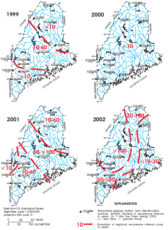 |
| Figure 5. Regional recurrence intervals for 7-day low flows in Maine, 1999-2002. |
Eight historical drought periods from 1947 to 2002 were analyzed. The two periods of statewide hydrologic drought that were most severe were 1947-50 and 1999-2002. These periods had low flows with greater than 100-year recurrence intervals for at least three stations across the State and 50- to 100-year recurrence intervals in additional parts of the State. The period 1963 to 1969 had low flows with recur- rence intervals of up to 70 years in the north and greater than 100 years in the south; however, this period was most remarkable for its duration—no other drought period spanned 7 years. By contrast, the single-year drought in 1995 had some of the lowest 7-day flows on record, second only to 2002, the most severe single year on record. In 1978, there was mild drought statewide with low-flow recurrence intervals of up to 35 years.
Regional droughts were severe during several periods. The period 1952-1953 was driest in the northern regions of the state, 1955-1959 was most severe in the south, and 1984-1988 was most severe in the central region.
Lombard, P.J., 2004, Drought conditions in Maine, 1999-2002—A historical perspective: U.S. Geological Survey Water-Resources Investigations Report 03-4310, 36 p.
Maine Agricultural Water Management Advisory Committee, 2003, Growing agriculture, sustainable agricultural water source and use policy and action plan: Maine Department of Agriculture, 18 p.
Maine Emergency Management Agency, 2002, Drought impact research summary report: Prepared by Volma Galubickaite, Market Decisions, April 2002, 22 p.
Stewart, G.J., Caldwell, J.M., and Cloutier, A.R., 2003, Water resources data, Maine water year 2002: U.S. Geological Survey Water-Data Report ME- 02-1, 230 p.
—Pamela J. Lombard; layout by Gloria L. Morrill
Information about current hydrologic conditions in Maine, and programs and publications of the USGS Maine District:
All recent USGS Maine District publications including the complete report describing drought conditions in Maine during 1999-2002:
http://me.water.usgs.gov/newreports.html
Current streamflow conditions in the United States:
http://water.usgs.gov/waterwatch/
Information about all programs and publications throughout the U.S. Geological Survey:
For more information or questions please contact:
District Chief
U.S. Geological Survey
196 Whitten Road
Augusta, Maine 04330
Telephone: (207) 622-8201
Email: dc_me@usgs.gov
Fact Sheet FS-2004-3021
March 2004
This report is available online in Portable Document Format (PDF). If you do not have the Adobe Acrobat PDF Reader, it is available for free download from Adobe Systems Incorporated.
View the full report in PDF 5.9 MB)
Document Accessibility: Adobe Systems Incorporated has information about PDFs and the visually impaired. This information provides tools to help make PDF files accessible. These tools and the accessible reader may be obtained free from Adobe at Adobe Access.
| AccessibilityFOIAPrivacyPolicies and Notices | |
 |
|