UNDERSTANDING EARTHQUAKE HAZARDS THROUGHOUT THE UNITED STATES
U.S. Department of the Interior
U.S. Geological Survey
Fact Sheet 2004-3033
March 2004
What are the faults in my area and where are they? When did they last have a large earthquake? Now you can find the answers to these questions online at http://earthquake.usgs.gov/hazards/qfaults/ through a user-friendly interface developed by the U.S. Geological Survey (USGS). This is the first nationwide compilation to provide up-to-date and comprehensive geologically based information on known or suspected active faults.
The USGS has released a new Quaternary Fault and Fold Database that summarizes geologic, geomorphic, and geographic information for about 2,000 Quaternary faults in the United States. This online database at http://earthquake.usgs.gov/harzards/qfaults/ contains information on faults and associated folds that are believed to be sources of earthquakes greater than magnitude 6 (M>6). The database is limited to structures with documented activity during the Quaternary (past 1.6 m.y.) because this period of geologic time is most relevant for studies of active earthquake faults.
Earthquakes occur when faults move beneath the Earth's surface. When the earthquake is large enough, movement will continue up to the surface and produce scarps, folds, or other geologic evidence of ground deformation. Although not all future earthquakes will occur on known faults, virtually all occur on preexisting faults. Thus, the faults included in this database have the most potential for future large earthquakes and provide a fairly accurate picture of earthquake hazards in the United States.
The Quaternary Fault and Fold Database includes information such as geologic setting, fault orientation, fault type, sense of movement, slip rate, recurrence (repeat) interval, and the time of the most recent surface-faulting event. Much of the information in the database is based on paleoseismology, which is the geologic study of prehistoric earthquakes. Paleoseismology combines geologic tools such as trenching with archeological-style analysis to determine the times and sizes of ancient earthquakes in the Quaternary Period. These studies extend the historic record of earthquakes and are extremely useful in assessing the potential hazard posed by the thousands of Quaternary faults in the United States.


 (click on image for larger version)
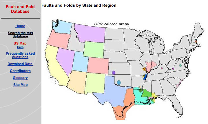
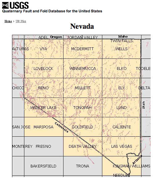
Three distinct but highly powerful interfaces can access the Quaternary Fault and Fold Database; each is tailored to different groups of users. There are two map interfaces. The U.S. Map interface (see below) is based on States or regions. Clicking on a State brings up the State map (Nevada is shown here), with all the 1°x 2° sheets for the State. Each sheet covers an area about 120 miles wide (E.-W.) and 60 miles high (N.-S.). Clicking one of the sheets brings up a shaded relief map of the area showing all the Quaternary faults. Each of these faults is numbered and linked to text descriptions in a table that is below the map. The static map images are small (typically 30 kb), so they load quickly using a standard dial-up modem.
The second map interface is a dynamic one, which utilitizes ArcInfo's Interactive Map Service (IMS). This map is linked to digital fault-and-fold files in a GIS (geographic information system). The interface loads a base map of the United States and a series of user-controlled layers, such as streams, roads, and towns, as well as the Quaternary faults and folds. Special tools allow users to zoom, pan, query, and link to the database (see next page). This powerful interface requires high-speed Internet access.
Users can also query the database. Queries can be simple, such as fault name, or as complicated as user-defined combinations of location, fault activity, and geologic characteristics.
 (click on image for larger version)
The database is designed to fulfill the needs of a broad group of users, ranging from the science community to the general public. Scientific and technical professionals engaged in seismological and paleoseismological research will find this Web site a powerful tool. The Web site facilitates making comparisons of spatial and temporal patterns of faulting at local, regional, and national scales and provides critical input for modeling plate motion and regional strain distribution. In addition, paleoseismologists and earthquake geologists will be able to identify where trenching studies have been conducted and review summaries of the results of those studies. Other geological specialists, such as hydrologists, can use it to address issues of ground-water availability and hydrothermal potential.
The seismic-hazard-assessment community will benefit from public access to all data available on potential earthquake sources in one location. The database will allow these users to identify faults that have likely produced strong ground motion in the geologically recent past and that may contribute to future seismic hazards. The database will continue to be the primary source for USGS seismic-hazards information on faults and fault-related folds in the United States, providing geologic information on the probable sources of past, current, and future earthquakes.
Other potential users include the earthquake-engineering community, the insurance industry, and companies managing large infrastructures, such as pipelines or power-transmission networks. In addition, local and State planners can use the database to locate potential earthquake sources on maps. Similarly, emergency-response officials can use the database to plan earthquake drills and to identify and fortify critical infrastructure near active faults.
 (click on image for larger version)
Finally, the general public is becoming increasingly aware of potential hazards in their environment. The USGS as well as State geological surveys frequently are called upon to respond to questions regarding the location of hazardous faults that may impact the lives of the population at large. Now individuals can find the answers to their questions directly in a user-friendly online interface.
Ten years in the making, this massive collection of data, which is estimated to contain about 10,000 pages of content on about 2,000 faults and folds (see below), was accomplished with the cooperation and assistance of State geological surveys as well as individuals in the academic and private sectors (see Web site for a complete list). Future additions to the database will include information for Alaska and Hawaii, as well as updates to information in the lower 48 States. The work of the USGS and its cooperators in developing this databaseis only one part of the ongoing USGS efforts to protect lives and property from future earthquakes throughout the United States.
For More Information Contact: Earthquake Hazards Program U.S. Geological Survey DFC PO Box 25046 MS-966 Denver, CO 80225
Quaternary Fault & Fold Database is at:http://earthquake.usgs.gov/hazards/qfaults/
Earthquake Hazards Program http://earthquake.usgs.gov/
Written by Michael Machette, Kathleen Haller, and Lisa Wald
Graphics and layout design by Lisa Wald
Document Accessibility: Adobe Systems Incorporated has information about PDFs and the visually impaired. This information provides tools to help make PDF files accessible. These tools convert Adobe PDF documents into HTML or ASCII text, which then can be read by a number of common screen-reading programs that synthesize text as audible speech. In addition, an accessible version of Acrobat Reader 6.0, which contains support for screen readers, is available. These tools and the accessible reader may be obtained free from Adobe at Adobe Access.
| AccessibilityFOIAPrivacyPolicies and Notices | |
| |
|