
|
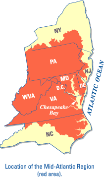 |
Location of the Mid-Atlantic Region (red area). |
Ground-Water Vulnerability to Nitrate Contamination in the Mid-Atlantic Region
USGS Fact Sheet FS 2004-3067

In cooperation with the U.S. Environmental Protection Agency Regional Vulnerability Assessment (ReVA) Program
Abstract
The U.S. Environmental Protection Agency’s (USEPA) Regional Vulnerability Assessment (ReVA) Program has developed a set of statistical tools to support regional-scale, integrated ecological risk-assessment studies. One of these tools, developed by the U.S. Geological Survey (USGS), is used with available water-quality data obtained from USGS National Water-Quality Assessment (NAWQA) and other studies in association with land cover, geology, soils, and other geographic data to develop logistic-regression equations that predict the vulnerability of ground water to nitrate concentrations exceeding specified thresholds in the Mid-Atlantic Region. The models were developed and applied to produce spatial probability maps showing the likelihood of elevated concentrations of nitrate in the region. These maps can be used to identify areas that currently are at risk and help identify areas where ground water has been affected by human activities. This information can be used by regional and local water managers to protect water supplies and identify land-use planning solutions and monitoring programs in these vulnerable areas.
Introduction
The USEPA has recognized that regional, State, and local water managers in the Mid-Atlantic Region need to have an estimate of ground-water vulnerability at the regional scale for both environmental (ecological) and human-health (public drinking-water consumption) purposes. During the last 3 years, the USEPA and the USGS have been conducting regional assessments of ground-water quality to develop estimates of regional ground-water vulnerability in the Mid-Atlantic Region (Greene and others, 2005). This research addresses questions of overall water-quality conditions in the region, and was designed to assess ground-water vulnerability to contamination.
Greene and others (2005) describe the statistical methodology (logistic regression) that can be used to assess the risk of nonpoint-source contamination of ground water in areas of the Mid-Atlantic Region where limited data are available. Spatial probability maps showing the likelihood of elevated concentrations of nitrate were developed to identify areas that currently are at risk at multiple management thresholds. These maps help identify areas where ground water has been affected by human activities, and can help regional and local water managers protect water supplies. In addition, validation and the uncertainty (confidence interval) of the model-predicted probabilities were developed and applied to all spatial probability maps (Greene and others, 2005).
Regional Vulnerability Assessment (ReVA) Program
The USEPA’s ReVA Program is developing and demonstrating approaches and tools for quantifying, assessing, and communicating ecological vulnerabilities at regional scales so that risk-management activities can be targeted and prioritized. ReVA’s focus is to develop a set of methods applicable to assess the distribution and condition of environmental resources and provide information to facilitate decision-making at the regional, watershed, and local scales.
Shallow Ground Water
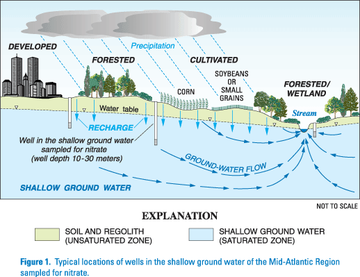 |
Figure 1: Typical locations of wells in the shallow ground water of the Mid-Atlantic Region sampled for nitrate. |
Ground water is that part of precipitation that does not evaporate or runoff to streams and rivers and infiltrates through the soil to the saturated zone beneath the water table. The unsaturated material above the water table contains air and water in spaces between the soil and rock particles and supports vegetation. In the saturated zone below the water table, ground water fills the spaces between the rock particles and within bedrock fractures (fig. 1). Recharge is the process by which precipitation is transmitted downward through the soil and ground water is replenished. The amount of water that is infiltrated and the location of the infiltrated water depends partly on land use and land cover. Areas that are undeveloped (natural or agricultural areas) with permeable soils and relatively flat slopes usually have greater recharge than urban areas covered with impervious surfaces (such as pavement).
The quality of ground water is determined by the mineral composition of the rocks themselves and the chemical composition of substances dissolved in the water. In addition, the chemical composition of the ground water may be affected by what is in the precipitation, and by biological and chemical reactions occurring on the land surface and in the soil zone. Human-related activities on the land surface may also affect the quality of ground water. These activities may increase the possibility of ground-water contamination through the disposal of wastes, the application of fertilizers, the development of septic systems in rural areas, and mining, among others. This potential contamination may find its way into the shallow ground water through recharge (fig. 1).
Nitrate in Ground Water
 |
Figure 2: Locations of ground-water wells sampled for nitrate and statistically grouped land cover in the Mid-Atlantic Region. |
Many contaminants in ground water occur naturally, however, elevated nitrate concentrations in ground water typically are caused by anthropogenic (human-related) activities that include crop fertilization and domestic septic systems. Spalding and Exner (1993) suggested that nitrate may be the most widespread contaminant in ground water. Because of the extensive presence of this contaminant in ground water and its potential health effects, areas of elevated nitrate concentrations may help identify environments that are susceptible to contamination (U.S. Environmental Protection Agency, 1996a).
Spatial probability maps of ground-water vulnerability were developed using nitrate because it has been suggested that it can be used as an indicator of overall ground-water quality (U.S. Environmental Protection Agency, 1996a). In addition, nitrate is a USEPA-regulated contaminant and its presence in high concentrations is a potential health risk. The USEPA has set a maximum contaminant level for nitrate in drinking water of 10 mg/L (milligrams per liter) as nitrogen (U.S. Environmental Protection Agency, 1996b).
Data and Variables
Water-quality data collected from October 1985 through September 1996 as part of the NAWQA Program (Gilliom and others, 1995) and other USGS projects were compiled in 1997 for a regional analysis of pesticides and nitrate in surface and ground water of the Mid-Atlantic Region (Ator, 1998; Ferrari and others, 1997; Ator and Ferrari, 1997). These ground-water-quality data consisted of 1,551 samples taken from 937 different sites. Ten sites were eliminated because of either missing or incomplete data, thereby reducing the data set to 927 sites (fig. 2).
Land cover and geology type have been related previously to the occurrence of elevated nitrate concentrations in ground water throughout the Mid-Atlantic Region (Ator and Ferrari, 1997; Nolan 2001). The other variables considered in the statistical model were nitrogen sources consisting of manure and/or fertilizer application, and atmospheric deposition. Population density and soils data consisting of hydrologic groups, organic matter, depth of soil layer, depth to water table, percent sand, silt, and clay also were explored with the statistical model to determine whether they were significant explanatory variables.
Logit Model
A logistic-regression (logit) statistical model was developed by relating statistically significant geographic variables and predicting the occurrence of nitrate in ground water above a predetermined management or environmental concentration threshold. After developing the best-fit logistic-regression model for each threshold, the entire Mid-Atlantic Region was evaluated in order to produce spatial probability maps depicting the likelihood of elevated nitrate concentrations exceeding a specified threshold.
Ground-Water Vulnerabilities at Multiple Management Concentration Thresholds
 |
Figure 3: Probability of nitrate concentrations in ground water exceeding 3 milligrams per liter as nitrogen in the Mid-Atlantic. |
|
Figure 4: Probability of nitrate concentrations in ground water exceeding 10 milligrams per liter as nitrogen in the Mid-Atlantic Region. |
Spatial probability maps showing the likelihood of elevated concentrations of nitrate can be used to identify areas that currently are at risk. These maps help identify areas where ground water has been affected by human activities, and can help regional and local water managers protect water supplies or target areas for further monitoring.
3 Milligrams per Liter
A map depicting the probability of nitrate exceeding 3 mg/L as nitrogen may be used for evaluating the relative risk of overall nitrate concentrations to ecological health of the region. Ground water in agricultural areas where manure is applied as fertilizer, or areas overlying carbonate rocks or coarse sand deposits may have a greater than 50-percent probability of nitrate concentrations exceeding 3 mg/L (fig. 3) (Greene and others, 2005).
10 Milligrams per Liter
Nitrate is a USEPA-regulated contaminant and its presence in high concentrations (above the regulatory limit of 10 mg/L as nitrogen) is a potential health risk (U.S. Environmental Protection Agency, 1996a). A map depicting the probability of nitrate concentrations exceeding 10 mg/L (fig. 4) could be used for evaluating the relative risk of high concentrations of nitrate to human health in the Mid-Atlantic Region. Ground water in agricultural areas where manure is applied as fertilizer and in carbonate rocks may have a greater than 50-percent probability of nitrate concentrations exceeding 10 mg/L (Greene and others, 2005).
References
Ator, S.W., 1998, Nitrate and pesticide data for waters of the Mid-Atlantic Region: U.S. Geological Survey Open-File Report 98-158, 5 p.
Ator, S.W. and Ferrari, M.J., 1997, Nitrate and selected pesticides in ground water of the Mid-Atlantic Region: U.S. Geological Survey Water-Resources Investigations Report 97-4139, 8 p.
Ferrari, M.J., Ator, S.W., Blomquist, J. D., and Dysart, J.E., 1997, Pesticides in surface water of the Mid-Atlantic Region: U.S. Geological Survey Water-Resources Investigations Report 97-4280, 12 p.
Gilliom, R.J., Alley, W.M., and Gurtz, M.E., 1995, Design of the National Water-Quality Assessment Program--Occurrence and distribution of water-quality conditions: U.S. Geological Survey Circular 1112, 33 p.
Greene, E.A., LaMotte, A.E., and Cullinan, K.A., 2005, Ground-water vulnerability to nitrate contamination at multiple thresholds in the Mid-Atlantic Region using spatial probability models: U.S. Geological Survey Scientific Investigations Report 2004-5118, 24 p.
Nolan, B.T. 2001, Relating nitrogen sources and aquifer susceptibility to nitrate in shallow ground waters of the United States: Ground Water, v. 39, no. 2, p. 290-299.
Spalding, R.F., and Exner, M.E., 1993, Occurrence of nitrate in groundwater--A review: Journal of Environmental Quality, v. 22, p 392-402.
U.S. Environmental Protection Agency, 1996a, Environmental indicators of water quality in the United States: Washington, D.C., U.S. Environmental Protection Agency, Office of Water, EPA 841-R-96-002, 25 p.
______ , 1996b, Drinking water regulations and health advisories: Washington, D.C., U.S. Environmental Protection Agency, Office of Water, EPA 822-B-96-002, 11 p.
Additional Information
For additional information, please contact:
District Chief, MD-DE-DC WSC
U.S. Geological Survey
8987 Yellow Brick Road
Baltimore, Maryland 21237
(410-238-4200)
or visit the Maryland-Delaware-District of Columbia District
Homepage on the World Wide Web at:
http://md.water.usgs.gov/
For information about the USEPA Regional Vulnerability Assessment (ReVA) Program, visit:
http://www.epa.gov/reva/
The U.S. Environmental Protection Agency, through its Office of Research and Development, partially funded and collaborated in the research described in this Fact Sheet under Interagency Agreement number DW 14939071 to the U.S. Geological Survey. It has been subjected to agency review and approved for publication.
Editor: Valerie M. Gaine
Graphics and design: Timothy W. Auer
Download USGS Fact Sheet FS 2004-3067 (15.0 MB)

![]() U.S. Department of the Interior | U.S. Geological Survey
U.S. Department of the Interior | U.S. Geological Survey
Persistent URL: https://pubs.water.usgs.gov/fs20043067
Page Contact Information: USGS Publishing Network
Page Last Modified: Tuesday, 29-Nov-2016 18:01:25 EST