

| Recent explosive eruptions at some of Alaska’s 52 historically active volcanoes have significantly affected air traffic over the North Pacific, as well as Alaska’s oil, power, and fishing industries and local communities. Since its founding in the late 1980s, the Alaska Volcano Observatory (AVO) has installed new monitoring networks and used satellite data to track activity at Alaska’s volcanoes, providing timely warnings and monitoring of frequent eruptions to the aviation industry and the general public. To minimize impacts from future eruptions, scientists at AVO continue to assess volcano hazards and to expand monitoring networks.
|
Since about 1700, when written records began to be kept for Alaska, more than 230 eruptions have been reported from volcanoes there. Most of these are found on a volcanic chain that stretches more than 1,500 miles along the Aleutian Islands, Alaska Peninsula, and Cook Inlet.
In 1988, the Alaska Volcano Observatory (AVO)-a cooperative effort of the U.S. Geological Survey (USGS), the University of Alaska Fairbanks Geophysical Institute, and the Alaska Division of Geological and Geophysical Surveys-was founded to monitor and minimize the effects of volcanic eruptions in Alaska.
Of the four dominant Cook Inlet volcanoes, only Augustine Volcano was monitored in 1988 with an adequate real-time seismic network necessary for detecting the small earthquakes that typically occur before eruptions. Located 180 miles southwest of populous Anchorage, Augustine is the most active and youngest of the Cook Inlet volcanoes. By the end of 1989, however, AVO scientists had installed new seismic stations and upgraded monitoring equipment on Augustine, Redoubt, and Mount Spurr Volcanoes.
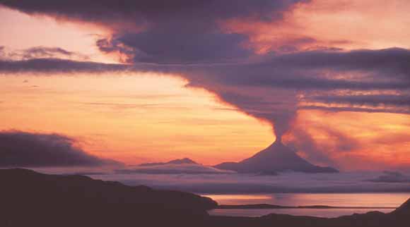 |
| This photo shows Kanaga Volcano, located 1,215 miles southwest of Anchorage in the western Aleutian Islands, during its 1993-95 eruption. At that time, the nearest volcano monitored with a real-time seismic network adequate to detect the small earthquakes that typically precede an eruption was Katmai, about 900 miles away. Since 1996, in order to detect volcanic unrest and eruptions along the Aleutian volcanic chain, scientists of the Alaska Volcano Observatory have significantly increased the number of volcanoes they monitor and study. A primary goal of the expansion is to provide accurate information about eruptions that could generate clouds of volcanic ash, a major threat to flying jet aircraft. By early 2004, Kanaga was among 27 volcanoes in Alaska monitored with ground-based seismic networks. All Alaskan volcanoes are monitored by satellite, using remote-sensing methods. (Copyrighted photo courtesy of Joe Meehan.) |
These volcano-monitoring networks proved essential for AVO to forecast eruptions of Redoubt in 1989-90 and Mount Spurr in 1992. A seismic network installed at Iliamna in 1992 allowed scientists to detect the rise of molten rock (magma) into the volcano 4 years later, an event that could have been a precursor to an eruption.
The explosive onset of the eruption of Redoubt Volcano on December 14, 1989, was preceded by only about 23 hours of intense swarms of small earthquakes. Because the volcano was monitored, this was sufficient time for AVO to warn officials and the public of the volcano’s restlessness and for AVO and Federal, State, and local government agencies to activate emergency plans before the eruption began.
A larger explosive event on December 15 sent a column of volcanic ash (rock fragments smaller than 1/12 inch) more than 40,000 feet above sea level. The ash was blown northward by strong winds, and the resulting eruption cloud nearly brought down a 747 jetliner carrying 244 people.
En route from Amsterdam to Anchorage, the plane unknowingly descended into the ash cloud and quickly lost power in all four engines as gritty ash and sulfurous gas filled the aircraft. Gliding powerless for more than four frightening minutes, the plane fell nearly 12,000 feet to within a few thousand feet of the ground. Disaster was averted when the engines were restarted and the jetliner landed safely in Anchorage. The 747 encountered the eruption cloud about 150 miles downwind from Redoubt, 90 minutes after the strong explosive event.
To help prevent such incidents, AVO scientists have worked closely with Federal agencies -- including the Federal Aviation Administration (FAA), National Weather Service (NWS), National Oceanic and Atmospheric Administration (NOAA) Anchorage Volcanic Ash Advisory Center, and Department of Defense-as well as the Kamchatkan Volcanic Eruption Response Team (a joint Russian-U.S. effort) and the aviation industry, to improve the flow of information about volcanic activity and eruption clouds in the North Pacific to airline dispatchers and pilots. This information is crucial for preventing other aircraft from accidentally encountering eruption clouds.
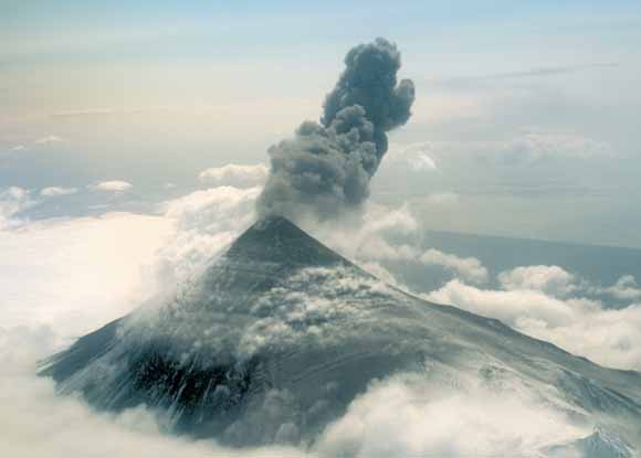 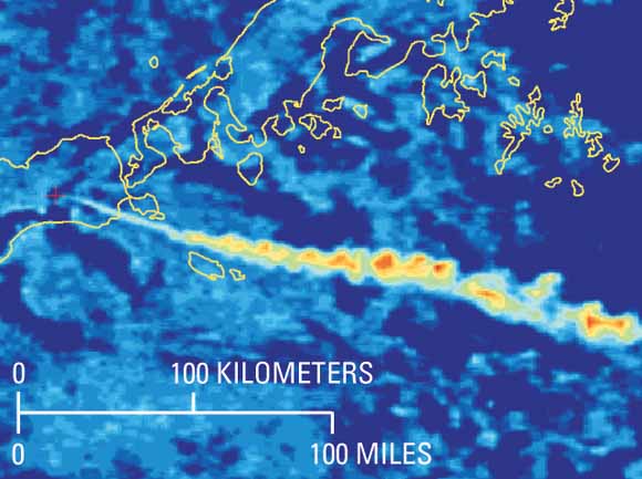 |
| In 1999, Shishaldin Volcano on Unimak Island erupted explosively, releasing small columns of volcanic ash and gas (top photo). This activity was punctuated by larger explosive events producing ash clouds that could be identified on satellite images (bottom). These ash clouds drifted for hundreds of miles, crossing heavily traveled international air routes. Completion of a seismic network on Unimak in 1998, as well as an ongoing satellite monitoring program, enabled Alaska Volcano Observatory scientists to issue timely notifications of the unrest and explosive activity at the volcano. (USGS photo by Robert McGimsey, April 1999.) |
In 1996, with Congressional funding provided through the FAA, AVO scientists began an aggressive effort to monitor and assess hazards at volcanoes on the Alaska Peninsula and along the distant Aleutian Islands, as well as east of Anchorage at Mount Wrangell. By the fall of 2008, AVO was operating more than 200 seismic stations capable of detecting earthquake activity at 31 volcanoes. AVO has also increased the corresponding data acquisition, storage, and analysis capability needed to track volcanic activity at Alaska’s volcanoes.
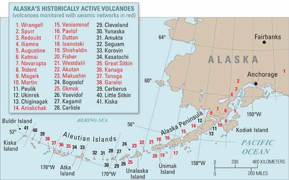 |
| Scientists of the Alaska Volcano Observatory have increased the number of volcanoes monitored with seismic networks from 4 in 1995 to 27 in early 2004. Griggs and Snowy Volcanoes near Katmai, although not historically active and therefore not shown, are monitored and included in the 27. New networks will be installed in the next few years at volcanoes in the far western Aleutian Islands. Data and images from meteorological satellites are also used daily to identify hot areas on volcanoes in Alaska and the Russian Far East and eruption clouds resulting from explosive activity |
A network of six to eight seismometers around a volcano is required to detect and accurately locate earthquake activity typically associated with magma rising into a volcano. Many eruptions are preceded by very small earthquakes (magnitude less than 1) or low-level tremor caused by the rising magma. Two or three seismometers are insufficient for accurately locating these events. Also, some redundancy is needed, particularly in Alaska, in case a few stations fail due to extreme weather or are destroyed by bears or eruptions.
AVO also uses remote-sensing data from several meteorological satellites to conduct daily monitoring and analysis of volcanic activity in the North Pacific region. Satellite images are routinely analyzed twice a day to identify signs of eruptions, such as volcanic ash clouds or thermal anomalies or "hot spots," which may indicate erupting lava or hot volcanic-gas emissions. During a period of unrest at one or more volcanoes, satellite data are analyzed more frequently, within minutes of when they are received.
Such regular analysis of satellite images has proven effective in detecting potentially hazardous activity at volcanoes in Alaska and Russia that are not seismically monitored. For example, AVO scientists detected an explosive eruption from Cleveland Volcano on February 19, 2001, during a routine daily analysis of satellite-generated images. The volcano was not monitored with a seismic network, but around-the-clock analysis of satellite data allowed AVO scientists to quickly provide accurate information of subsequent ash clouds from explosive eruptions.
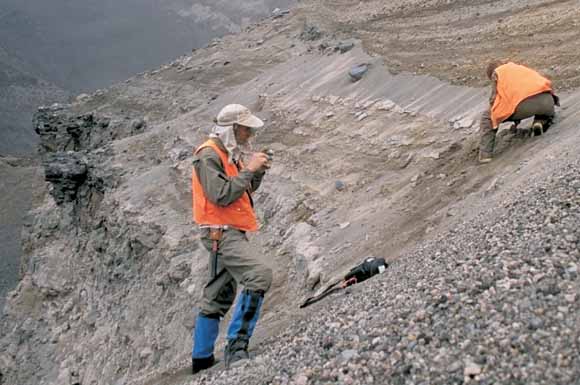 |
| Geologists examine rock layers in Aniakchak Caldera to decipher the volcano’s eruptive history and determine its future potential hazards. The caldera, a large volcanic depression, formed during a catastrophic explosive eruption 3,500 years ago. These deposits within the caldera were formed by subsequent smaller eruptions. |
AVO’s volcano-monitoring capability has significantly expanded since its inception in 1988. With each new seismic network, volcano-hazard assessment, eruption, or period of volcano unrest, scientists are increasing their ability to provide timely, accurate information about Alaska’s active volcanoes.
By Steven R. Brantley, Robert G. McGimsey, and
Christina A. Neal
Edited by James W. Hendley II and Peter Stauffer
Graphic design by Susan Mayfield and Sara Boore
Web page by Carolyn Donlin and Michael Diggles
Banner design by Bobbie Myers
COOPERATING ORGANIZATIONS
Alaska Division of Geological and Geophysical Surveys
Geophysical Institute University of Alaska Fairbanks
Department of Defense
Federal Aviation Administration
Kamchatka Volcanic Eruption Response Team
National Oceanic and Atmospheric Administration
National Weather Service/Anchorage Volcanic Ash Advisory Center
U.S. Coast Guard
For questions about the content of this report, contact Steve Brantley
For more information contact:
Alaska Volcano Observatory
Tel. (907) 786-7497, Fax (907) 786-7425
4200 University Drive
Anchorage, AK 99508
http://www.avo.alaska.edu/
PDF version of this fact sheet (fs2004-3084_v1.1.pdf; 520 KB)
Suggested citation and version history
Download a free copy of the latest version of Adobe Reader.
| Help
| PDF help
| Publications main page | Western Fact
Sheets |
| U.S. Geological Survey
| Geologic Division | Volcano Hazards Program |
| Department of the Interior
| Privacy Statement | Disclaimer
| Accessibility |
URL of this page: https://pubs.usgs.gov/fs/2004/3084/
Maintained by: Michael Diggles
Created: August 13, 2004
Last modified: August 13, 2004 (mfd)