
|
The Pu‘u ‘O‘o-Kupaianaha eruption of Kilauea is the volcano’s longest rift-zone eruption in more than 600 years. Since the eruption began in 1983, lava flows have buried 45 square miles (117 km2) of the volcano and added 560 acres (225 ha) of new land to the Island of Hawai‘i. The eruption not only challenges local communities, which must adapt to an ever-changing and sometimes-destructive environment, but also has drawn millions of visitors to Hawai‘i Volcanoes National Park. U.S. Geological Survey (USGS) scientists closely monitor and evaluate hazards at Hawai‘i’s volcanoes and also work with park rangers to help ensure safe lava viewing for visitors. |
 |
| Glowing lava flows erupt from vents on the south flank of the Pu‘u ‘O‘o cone. Ongoing collapse of the southwest (left) side of the cone has formed a scallop-shaped scar, revealing red layers of welded spatter (deposited as clots of molten lava) that underlie loose tan-colored cinders (bubble-filled, glassy lava pieces that solidified while still airborne). (USGS photo by Richard Hoblitt, January 2004.) |
On the evening of January 29, 1997, scientists at the USGS Hawaiian Volcano Observatory (HVO) hastily returned to work as a swarm of earthquakes struck Kilauea’s east rift zone. Deep within the rift zone, magma (molten rock) was escaping from the conduit leading to the Pu‘u ‘O‘o vent, cutting off the supply to the ongoing eruption. The lava pond at Pu‘u ‘O‘o drained, and residents 10 miles (16 km) away heard a low, rumbling roar as the crater floor dropped 500 feet (150 m) and the west wall of the Pu‘u ‘O‘o cone collapsed. A few hours later, magma found a new path to the surface in nearby Napau Crater, and lava fountains lit up the night sky. At dawn, HVO scientists were even more impressed when they saw the new gap in the west flank of Pu‘u ‘O‘o. Even after 15 years, monitoring the eruption was anything but routine.
Kilauea is Hawai‘i’s youngest volcano and one of the world’s most active. More than 90 percent of its surface has been covered by lava flows in the past 1,000 years. Kilauea erupts either at its summit or along its east or southwest rift zone. From the early 1800s through 1954, the volcano erupted mainly in its summit caldera. Since 1955, however, most eruptions have occurred along the east rift zone. The Pu‘u ‘O‘o-Kupaianaha eruption, which has produced more than half the volume of lava erupted by Kilauea in the past 160 years, is by far the largest of these.
 |
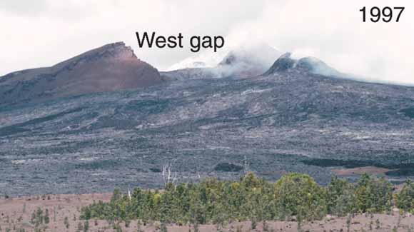 |
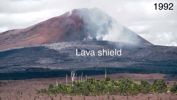
During the first 3½ years of the eruption, fallout from lava fountains at Pu‘u ‘O‘o built a cinder-and-spatter cone 835 feet (255 m) high, more than twice as high as any other cone on Kilauea’s east rift zone. Cone growth ceased after the activity shifted to Kupaianaha in mid-1986. When the eruption returned to Pu‘u ‘O‘o in 1992, lava flows from flank vents built a “shield” against the west flank of the cone (top). In 1993, collapse pits appeared on the west flank of Pu‘u ‘O‘o as subsidence over the flank vents undermined the cone. When the crater floor dropped in January 1997, the weakened flank also failed, leaving the prominent “west gap.” Note growth of the shield (bottom). (USGS photos by Tari Mattox and Christina Heliker.) |
The Pu‘u ‘O‘o-Kupaianaha eruption began on January 3, 1983, on a remote stretch of the east rift zone, 12 miles (19 km) from the summit caldera. From mid-1983 through mid-1986, Pu‘u ‘O‘o erupted every 3 to 4 weeks, usually for less than 24 hours. Towering lava fountains, as high as 1,500 feet (460 m), were visible and audible for miles. The fountains fed thick, blocky flows of ‘a‘a, the less fluid of the two types of Hawaiian lava flows. In July 1986, the eruption shifted 2 miles (3 km) downrift to a new vent, Kupaianaha, initiating 51/2 years of continuous, quiet effusion. A lava pond formed over the vent, and frequent overflows built a broad shield 185 feet (56 m) high in less than a year.
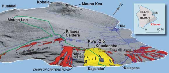 |
Lava flows erupted from Kilauea since A.D. 1790 (shown in red) have originated from the summit caldera or the rift zones. Flows from the present eruption (shown in yellow) span more than 9 miles (15 km) along the coast and straddle the national park boundary (green line). The Island of Hawai‘i consists of five volcanoes: Kohala, Mauna Kea, Hualalai, Mauna Loa, and Kilauea. |
On November 28, 1986, flows from Kupaianaha reached the ocean, 7.5 miles (12 km) away, cutting a swath through the community of Kapa‘ahu and closing the coastal highway. Over the next 5 years, lava flows overran houses on either side of the ever-widening flow field.
By 1991, lava output from Kupaianaha was in steady decline. Magma pressure increased uprift of Kupaianaha, and new fissures erupted between Kupaianaha and Pu‘u ‘O‘o for 3 weeks in November 1991. Lava discharge from Kupaianaha continued to wane and, on February 7, 1992, finally stopped.
Ten days later, the activity returned to Pu‘u ‘O‘o. Low lava fountains erupted from a fissure on the west flank of the massive cone. This was the first in a series of flank vents that built a lava shield 260 feet (80 m) high, banked against the slope of Pu‘u ‘O‘o. From 1992 through 2003, nearly continuous effusion from these vents sent lava flows to the ocean within the national park. In May 2002, lava flows from a new vent on the west side of the shield advanced to the ocean along the western margin of the flow field. Flows entered the ocean near the end of Chain of Craters Road from July 2002 to June 2003, drawing as many as 4,000 visitors per day. In late 2003, the activity retreated upslope. Lava entered the ocean again from May to August 2004
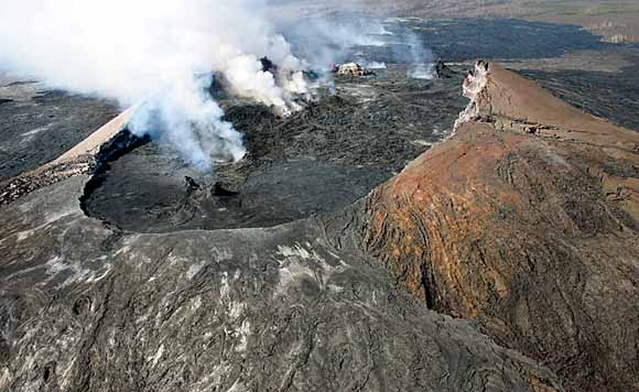 |
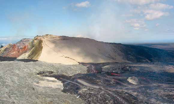
Volcanic gases escape from vents on the crater floor of Pu‘u ‘O‘o. Since 1987, repeated collapses of the cone have formed a crater more than 1,300 feet (400 m) long. The crater has been as deep as 690 feet (210 m); infilling with lava has reduced the depth to 15 feet (5 m) below the lowest rim. (USGS photo by Christina Heliker, April 2004.) |
The high lava fountains at Pu‘u ‘O‘o from 1983 to 1986 produced mainly ‘a‘a flows that were typically 10 to 15 feet (3-5 m) thick. Because of the short duration of each fountaining episode, none of these flows reached the ocean.
After the eruptive activity changed from episodic to continuous in 1986, pahoehoe, a type of lava more fluid than ‘a‘a, predominated. The main lava channels exiting the Kupaianaha and Pu‘u ‘O‘o vents crusted over and formed tubes that eventually extended to the ocean. Tubes insulate lava from heat loss, allowing it to remain fluid and travel far without cooling. Tube-fed pahoehoe flows have formed a barren plain of lava as much as 115 feet (35 m) thick that spans 9.5 miles (15 km) at the coast
Since late 1986, lava has poured into the ocean more than 70 percent of the time, by far the longest such interval in at least 600 years. New land is created as lava deltas build seaward over steep submarine slopes of lava rubble, black sand, and pillow lava (the submarine form of pahoehoe). Such steep slopes are unstable and prone to slumping, which removes support for the active, leading edge of the lava delta, or "bench." When a bench suddenly collapses, several acres of land can slide into the sea in less than a minute. Large collapses are highly dangerous and frequently precipitate violent steam explosions and scalding waves. Four people have died near Kilauea’s active lava deltas (see USGS Fact Sheet 152-00, Viewing Hawai‘i’s Lava Safely-Common Sense is Not Enough).
|
ERUPTION STATISTICS 1983 TO 2004 Lava flows
• Area covered: 45.1 square miles (116.9 km2)
• Maximum height, 1987: 835 feet (255 m)
|
The current eruption ranks as Kilauea’s most destructive since A.D. 1790. Between 1983 and 1991, lava flows repeatedly invaded communities on Kilauea’s southern coast. In 1990, the flows from Kupaianaha covered the village of Kalapana, leading to a Federal disaster declaration for coastal communities destroyed by the eruption. At the same time, the creation of new land and stunningly beautiful flows in the national park have drawn millions of people to experience and enjoy volcanic activity up close.
The continuous emission of more than 1,000 tons of sulfur dioxide (SO2) gas each day from Kilauea results in volcanic smog, or “vog,” downwind of the volcano. SO2 in the eruption plume reacts with oxygen, water, and particles in the air to form the sulfuric acid droplets and solid sulfate particles that produce vog and corrosive acid rain. Vog aggravates preexisting respiratory ailments and damages crops.
Since early 1992, lava flows have remained mostly within Hawai‘i Volcanoes National Park, reducing the immediate threat to residential areas. The geologic history of Kilauea, however, indicates a high likelihood of continued activity on the east rift zone, even after the present eruption ends. To provide reliable and timely warnings of eruptions, USGS scientists at HVO continuously monitor Hawai‘i’s volcanoes.
By Christina Heliker and Steven R. Brantley
Edited by James W. Hendley II
Graphic design by Susan Mayfield, Sara Boore, and Steven R. Brantley
Web design by Michael Diggles
Banner design by Bobbie Myers
COOPERATING ORGANIZATIONS
Center for the Study of Active Volcanoes, University of Hawai‘i at Hilo
Hawai‘i County Civil Defense
Hawai‘i Volcanoes National Park
For questions about the content of this report, contact Christina Heliker
For more information contact:
U.S. Geological Survey
Hawaiian Volcano Observatory
P.O. Box 51, Hawaii Volcanoes National Park, HI 96718
Tel: (808) 967-7328, Fax: (808) 967-8890
http://hvo.wr.usgs.gov/
or
USGS Volcano Hazards Program
http://volcanoes.usgs.gov/
See also other USGS Hawaiian volcano Fact Sheets
http://volcanoes.usgs.gov/Products/sproducts.html
PDF version of this fact sheet (300 KB)
Download a copy of Acrobat Reader for free
| Help | PDF help | Western Publications main page | Western Fact Sheets |
| Department of the Interior
| Privacy Statement | Disclaimer
| Accessibility |
URL of this page: https://pubs.usgs.gov/fs/2004/3085/
Maintained by: Michael Diggles
Created: November 30, 2004
Last modified: July 10, 2005 (mfd)