
Fact Sheet 2004–3098
September 2004
The U.S. Geological Survey's National Water-Quality Assessment (NAWQA) Program is assessing the sources, transport, and fate of chemicals applied to crops in agricultural basins across the Nation (referred to as "study units," see map). Chemicals selected for study include nutrients (nitrogen and phosphorus) and about 50 commonly used pesticides and their transformation products, including triazine and acetanilide herbicides such as atrazine and metolachlor, and organophosphorus insecticides such as chlorpyrifos and diazinon.
The basins in the studies represent a range of agricultural settings—with varying crop types and agricultural practices related to tillage, irrigation, artificial drainage, and chemical use—as well as a range of landscapes with different geology, soils, topography, climate, and hydrology. Consistent methodology and analysis allow comparisons among the different basins. This study design leads to an improved understanding of the many factors that can affect the movement of water and chemicals in different agricultural settings (see "Complex factors," next page).
Information from these studies will help with decision-making related to chemical use, conservation, and other farming practices that are used to reduce runoff of agricultural chemicals and sediment from fields. This information also will benefit the U.S. Environmental Protection Agency, the Department of Agriculture, local and regional water managers, and agricultural chemical manufacturers who are involved in managing chemical use and pesticide registration.
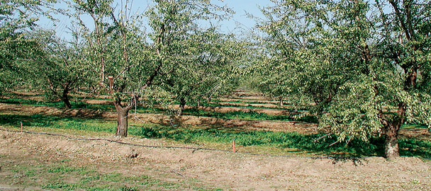
Photo by Joseph Domagalski, USGS
A unique feature of these studies is the simultaneous assessment of agricultural chemicals throughout the hydrologic system at many scales.
In a small sub-basin within each study unit, data are collected on precipitation, wind speed, solar radiation, and air temperature; on streamflow (discharge); on water quality in streams, runoff, tile drains and shallow ground water; and on sediment quality in the streambed and agricultural soils. Streamflow and water quality also are assessed in the larger river network of the study unit. A network of wells is sampled to characterize the age, movement, and quality of shallow ground water; in most areas, wells along a 1- to 2-mile-long flow system are used to characterize chemical transport rates and transformation processes in the shallow system recharged within about the last 50 years.
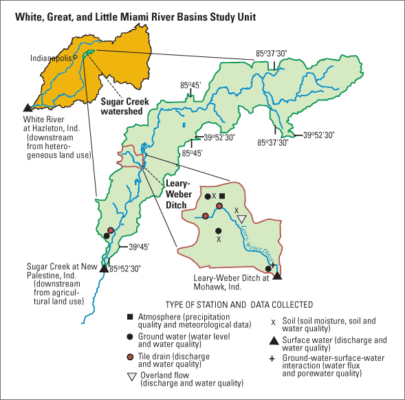
In this study area near Indianapolis, Ind., the 2.4-square-mile (mi2) drainage area of the Leary-Weber Ditch is nested within the Sugar Creek watershed, a 95-mi2 agricultural basin nested within the larger, more heterogeneous White River Basin (more than 11,000 mi2).
These USGS studies address the complex processes controlling the transport, and fate of agricultural chemicals in streams and ground water, as well as how these processes are affected by natural factors, agricultural practices, and chemical properties.
Not all of the agricultural chemicals remain in the soil or are taken up by plants; a small amount can move upward into the atmosphere, downward through the soil into shallow ground water and underlying aquifers, or across the land into streams. This movement is controlled, in part, by natural factors such as hydrogeology, climate, topography, and soils, making water resources in some basins more vulnerable to contamination than others.
For example, throughout much of the upper Midwest, large amounts of chemicals are used on corn and soybean fields, but underlying ground water generally has relatively low concentrations of agricultural chemicals because the low permeability soils and glacial till minimize downward movement. On that part of the Delmarva Peninsula in Maryland, ground water is more vulnerable because of permeable soils underlain by sand and gravel, which enable rapid infiltration and downward movement of water and chemicals. Streams are most vulnerable to contamination from agricultural chemicals where poorly drained soils, agricultural practices, and topography encourage the rapid movement of water off of fields, or where tile drains and ditches quickly transport agricultural runoff from fields to streams, such as in the White River Basin in Indiana.
Natural transformation processes, such as denitrification, and chemical properties play an important role in transport. For example, poorly drained and poorly oxygenated soils with organic-rich sediments can promote denitrification, which can thereby reduce nitrate concentrations entering streams.
Some chemicals, such as atrazine and nitrate, readily dissolve and move with water in both streams and aquifers, whereas many forms of phosphorus and some pesticides, such as chlorpyrifos and permethrin, attach to soil particles and are transported to streams with eroded soil, particularly during times of runoff from precipitation or irrigation. Ground water typically is less vulnerable to contamination by chemicals that strongly attach to soils.
Some chemicals, such as atrazine, are slowly transformed by natural processes and can persist in soil and water for years or even decades. Other pesticides, such as diazinon, are relatively unstable in water and break down to other compounds within days or weeks. Chemicals that persist for a long time are more likely to be transported farther than compounds that are short lived.
Chemical transport also is influenced by agricultural practices, such as methods of tillage and drainage, and chemical use. For example, farmers may leave the soil surface undisturbed from harvest to planting (referred to as "no-till"), and may plant and maintain buffer strips around fields and streams. By decreasing runoff and soil erosion, these practices also decrease chemical transport. Use of drip irrigation in lieu of furrow irrigation decreases the amount of water lost to ditches or evaporation, and allows better control of the amounts of pesticides and nutrients added to irrigation water.
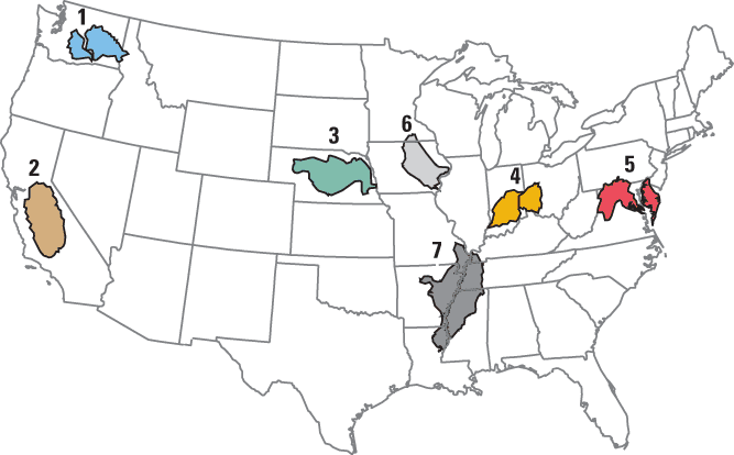
Studies were begun in 2001 in five agricultural basins within NAWQA study units. Two more studies (gray-shaded study units in map) are scheduled to begin in 2005. As the studies progress, additional basins will likely be added. The study areas represent diverse agricultural settings, as defined by crop and animal production activities, management practices (related to chemical use, irrigation, drainage, and tillage), and hydrogeologic settings (a combination of surface and subsurface systems with characteristic climate, topography, geology, and soils).
| NAWQA study unit and agricultural chemicals study area | Major crops and animal production | Primary agricultural management practices* | Hydrogeologic setting | Major water-quality issues | |
|---|---|---|---|---|---|
| 1 | Central Columbia Plateau-Yakima River Basin Study Unit (Granger Drain sub-basin in Washington) | Orchards, vineyards, corn, hay, mixed row crops; intensive dairy | Spray, furrow, and drip irrigation; water delivery and drainage channels; conventional tillage and no-till; tile drains, ditches; widespread use of polyacrylamide (PAM) | Arid; deep loess soils underlain by basalt | Pesticides and nutrients in streams, drains, and ground water; water temperature; sediment and fecal bacteria in streams |
| 2 | San Joaquin-Tulare Basins Study Unit (Lower Merced River and Mustang Creek watershed in California) | Orchards, vineyards, mixed row crops; intensive dairy and poultry | Spray, furrow, flood, and drip irrigation; conventional tillage and no-till | Arid; permeable sands with relatively shallow water tables and poorly drained soils with deeper water tables | Runoff from winter rains carries pesticides to streams, with toxicity to aquatic invertebrates; nitrate in ground water in localized areas |
| 3 | Central Nebraska Basins Study Unit (Maple Creek watershed in Nebraska) | Corn, soybeans, alfalfa, hay, and wheat; beef cattle, some dairy and hogs | Mostly dryland; central pivot irrigation; conventional and conservation tillage, no-till increasing; some tile drains | Semiarid; permeable surface and subsurface | Herbicides and nutrients in streams and ground water, including in drinking-water wells; sediment in streams |
| 4 | White, Great, and Little Miami River Basins Study Unit (Sugar Creek watershed in Indiana) | Corn and soybeans; few to no animals | No irrigation; conventional and reduced tillage; tile drains and ditches | Humid; poorly drained soils; relatively impermeable glacial till and sediment | Herbicides in streams; accelerated transport of pesticides and nutrients to streams via tile drains |
| 5 | Potomac River Basin & Delmarva Peninsula Study Unit (Morgan Creek watershed in Maryland) | Corn and soybeans; some dairy | Some central pivot irrigation; conventional tillage and no-till | Humid; moderately to well drained soils; permeable sand and gravel suficial aquifer | Herbicides in streams and ground water, including drinking-water wells; nitrate greater than drinking-water standards in some drinking-water wells |
| 6 | Eastern Iowa Basins Study Unit (South Fork of the Iowa River watershed in Iowa) | Corn and soybeans; extensive hog confined feeding operations | No irrigation; conventional and conservation tillage; tile drains and ditches | Humid; poorly to moderately drained soils from glacial till | Herbicides and nutrients in streams, transported by overland flow and tile drains; potential for pharmaceuticals in streams and ground water from hog operations |
| 7 | Mississippi Embayment Study Unit (Bogue Phalia watershed in Mississippi) | Cotton, rice, soybeans, corn; catfish, few other animals | Flood, pivot, spray, and furrow irrigation | Subtropical; poorly drained alluvial soils | Streams affected by residual organochlorines and currently used pesticides, fine sediment, and low dissolved oxygen |
* Pesticide and fertilizer use is heavy in each study area, and cattle or hog manure is applied to fields in some places.
The findings of these studies will provide a better understanding of the transport and fate of selected agricultural chemicals in various agricultural and environmental settings. This understanding will enable the development of models to extrapolate information from direct water-quality measurements to similar, yet unmonitored, agricultural areas. Farmers will gain a better understanding of how their operations affect water quality. The findings also will guide future scientific research on processes affecting transport and fate of agricultural chemicals and help water policy makers:
Paul Capel, Team Leader
(612) 625-3082 capel@usgs.gov
Lead Scientists:
Kathy McCarthy, Central Columbia
Plateau-Yakima River Basin
(503) 251-3527 mccarthy@usgs.gov
Jason Vogel, Central Nebraska Basins
(402) 437-5129 jrvogel@usgs.gov
Tracy Hancock, Potomac River Basin and Delmarva Peninsula
(804) 261-2618 thancock@usgs.gov
Joseph Domagalski, San Joaquin-Tulare River Basins
(916) 278-3077 joed@usgs.gov
Nancy Baker, White, Great, and Little Miami River Basins
(317) 290-3333 ntbaker@usgs.gov
Stephen Kalkhoff, Eastern Iowa Basins
(319) 358-3611 sjkalkho@usgs.gov
Richard Coupe, Mississippi Embayment
(601) 933-2982 rhcoupe@usgs.gov
http://water.usgs.gov/pubs/fs/fs08003
http://water.usgs.gov/pubs/fs/fs08103
http://water.usgs.gov/pubs/fs/fs08203
http://water.usgs.gov/pubs/fs/fs08303
http://water.usgs.gov/pubs/fs/fs08403
Gianessi, L.P. and Silvers, C.S., 2000, Trends in Crop Pesticide Use: Comparing 1992 and 1997: Washington, D.C., National Center for Food and Agricultural Policy, http://www.ncfap.org/ncfap/trendsreport.pdf, accessed June 3, 2004.
Heimlich, Ralph, 2003, Agricultural Resources and Environmental Indicators, 2003: Agriculture Handbook No. (AH722): U.S. Department of Agriculture Economic Research Service http://www.ers.usda.gov/publications/arei/ah722/, accessed May 25, 2004. [available online only]
Hamilton, P.A., Miller, T.L., and Myers, D.N., 2004: Water quality in the Nation's Streams and Aquifers—Overview of Selected Findings, 1991-2001: U. S. Geological Survey Circular 1265, 20 p. [available online at http://water.usgs.gov/pubs/circ/2004/1265/]
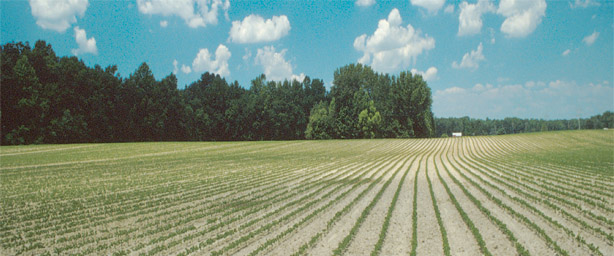
Photo by David Usher, USGS
Soybean field on well-drained farmland on the Delmarva Peninsula.
Document Accessibility: Adobe Systems Incorporated has information about PDFs and the visually impaired. This information provides tools to help make PDF files accessible. These tools convert Adobe PDF documents into HTML or ASCII text, which then can be read by a number of common screen-reading programs that synthesize text as audible speech. In addition, an accessible version of Acrobat Reader 6.0, which contains support for screen readers, is available. These tools and the accessible reader may be obtained free from Adobe at Adobe Access.
| AccessibilityFOIAPrivacyPolicies and Notices | |
 |
|