
The U.S. Geological Survey (USGS) recently completed a new assessment of undiscovered oil and gas resources for the Yukon Flats Tertiary Composite Total Petroleum System in east-central Alaska. The assessment indicates the probable existence of technically recoverable oil and gas resources, with mean estimates of about 5.5 trillion cubic feet of undiscovered natural gas, 173 million barrels of undiscovered oil, and 127 million barrels of natural-gas liquids in conventional accumulations. |
Yukon Flats is a region of low, forested hills and flatlands with numerous streams and lakes, situated generally to the east of the Trans-Alaska Pipeline System in east-central Alaska. U.S. Geological Survey (USGS) scientists recently finished their first detailed assessment of the undiscovered oil and gas potential of the Yukon Flats region. Previously, the region's potential had been assessed only as a part of larger oil and gas assessments for central Alaska.
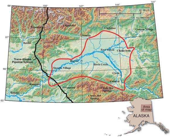 |
U.S. Geological Survey scientists recently finished their first detailed assessment of the undiscovered oil and gas potential of the Yukon Flats Tertiary Composite Total Petroleum System (red outline) of east-central Alaska. The assessment indicates the probable existence of technically recoverable oil and gas resources. |
At present, there is no commercial petroleum production in the Yukon Flats region, but the new USGS assessment indicates the probable existence of technically recoverable oil and gas resources—in other words, those resources that can be discovered, developed, and produced by using current technology—in rocks of Tertiary age (about 1.8 to 65 million years old). The assessment was based on the general geologic elements used to define a Total Petroleum System (TPS), which include hydrocarbon source rocks (source-rock maturation, hydrocarbon generation, and hydrocarbon migration), reservoir rocks (sequence stratigraphy and petrophysical properties), and hydrocarbon traps (trap formation and timing). The Yukon Flats TPS is a “composite” petroleum system because available geologic evidence suggests that it contains multiple horizons of petroleum source rocks—including shale, mudstone, and coal of Tertiary and Mesozoic age-rather than a single horizon of source rock, as in some other petroleum systems of the world.
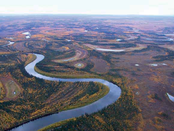 |
The 13,500-square-mile (35,000 km2) Yukon Flats assessment area is characterized by low, forested hills, flatlands, meadows, meandering streams, and lakes. This photograph, taken northwest of Circle, Alaska, shows a typical landscape of the region. |
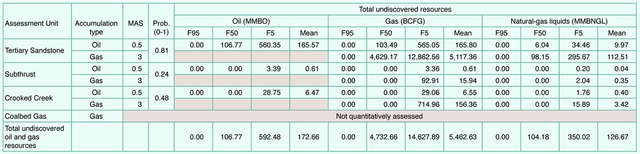
Using this geologic framework, the USGS defined four Assessment Units within the Yukon Flats Tertiary Composite TPS-the Tertiary Sandstone Assessment Unit, the Subthrust Assessment Unit, the Crooked Creek Assessment Unit, and the Coalbed Gas Assessment Unit. Undiscovered, conventional oil and gas resources were quantitatively assessed for the Tertiary Sandstone, Subthrust, and Crooked Creek Assessment Units. The Coalbed Gas Assessment Unit, which may contain continuous (unconventional) gas resources, was not quantitatively assessed for this study and will be considered at a future date, along with other potential coalbed-gas units in Alaska.
 |
Photograph looking northward across the Trans-Alaska Pipeline System, showing low, forested hills along the Yukon River (right-hand edge of photo), near the west edge of the Yukon Flats assessment area. |
The USGS assessment strategy provides estimates of the volumes of undiscovered petroleum (mainly oil, gas, and natural-gas liquids) that are technically recoverable and that have the potential to be added to reserves in a 30-year forecast span. For the Yukon Flats Tertiary Composite Total Petroleum System, the USGS estimates a mean of 5.46 trillion cubic feet of gas (TCFG), a mean of 172.66 million barrels of oil (MMBO), and a mean of 126.67 million barrels of natural-gas liquids (MMBNGL). Nearly all of these undiscovered resources are estimated to be within the Tertiary Sandstone Assessment Unit. Of the 5.46 TCGF of undiscovered gas at the mean, about 97% (5.28 TCGF) is believed to be within the Tertiary Sandstone Assessment Unit, less than 1% (0.02 TCGF) is in the Subthrust Assessment Unit, and about 3% (0.16 TCGF) is in the Crooked Creek Assessment Unit. Of the 172.66 MMBO of undiscovered oil at the mean, about 96% (165.57 MMBO) is believed to be within the Tertiary Sandstone Assessment Unit, less than 1% (0.61 MMBO) is in the Subthrust Assessment Unit, and about 4% (6.47 MMBO) is in the Crooked Creek Assessment Unit.
|
Yukon Flats Tertiary Composite Total Petroleum System assessment results. [MMBO, million barrels of oil; BCFG, billion cubic feet of gas; MMBNGL, million barrels of natural gas liquids; MAS, minimum accumulation size assessed [MMBO or BCFG]; Prob., probability of at least one accumulation equal to or greater than the MAS. Results shown are fully risked estimates. For gas fields, all liquids are included under the natural gas liquids category. F95 denotes a 95% chance of at least the amount tabulated. Other fractiles are defined similarly. Fractiles are additive only under the assumption of perfect positive correlation. Shading indicates not applicable.] |
(click table for a larger version) |
By Richard G. Stanley, Thomas S. Ahlbrandt; Ronald R. Charpentier, Troy A. Cook, Jesse M. Crews, Timothy R. Klett, Paul G. Lillis, Robert L. Morin, Jeffrey D. Phillips, Richard M. Pollastro, Elisabeth L. Rowan, Richard W. Saltus, Christopher J. Schenk, Megan K. Simpson, Alison B. Till, and Sandra M. Troutman
Edited by James W. Hendley II
Graphic design by Susan Mayfield and Sara Boore
For Further Information
Supporting geologic studies of the Yukon Flats Tertiary Composite Total Petroleum System and the Assessment Units, and the methodology used in the Yukon Flats assessment, are in preparation.
Assessment results are available at the USGS Central Energy Team Web site,
http://energy.cr.usgs.gov/oilgas/noga/
or contact
Richard G. Stanley: rstanley@usgs.gov (650) 329-4918
PDF version of this fact sheet (2.3 MB)
Press images. This folder contains press-quality images that were used in this pubication (36.8 MB)
Download a copy of Acrobat Reader for free
| Help | PDF help | Western Publications main page | Western Fact Sheets |
| Department of the Interior
| Privacy Statement | Disclaimer
| Accessibility |
URL of this page: https://pubs.usgs.gov/fs/2004/3121/
Maintained by: Michael Diggles
Created: December 14, 2004
Last modified: December 14, 2004 (mfd)