In southern Florida, water-management practices must support a large and rapidly growing urban population as well as intensive agricultural activities. However, these water management practices have altered the natural hydrology of the Everglades ecosystem, including Florida Bay and the estuaries along the southwestern coast of Florida. During the past few decades, the coastal environments of southern Florida have shown signs of ecological deterioration that may be attributed to changes in freshwater inflows and associated salinity and nutrient level increases in estuarine waters. With the goal of the Comprehensive Everglades Restoration Plan (CERP) to restore the quantity, timing, and distribution of freshwater flows within the Everglades to more natural conditions, changes are expected to occur in the major rivers and creeks flowing into the estuaries. However, substantial hydrologic information gaps exist throughout the Everglades wetlands and estuaries that need to be addressed for the restoration process to succeed. Specifically, hydrologic information throughout the Everglades and adjacent ecosystems is required for the development of restoration strategies and for future evaluation of restoration results.
To address these issues, the U.S. Geological Survey (USGS) began a series of studies in 1995 to monitor the major rivers and creeks that discharge freshwater into northeastern Florida Bay and the southwestern estuaries of Everglades National Park (ENP). These studies provide: (1) flow, salinity, water temperature, and water-level data for research applications including model development and calibration; and (2) supply base-line information for other physical, biological, and chemical studies being conducted in these areas. As part of these studies, a network of 35 estuarine and wetland hydrologic monitoring stations (fig. 1) has been constructed. Historical data for some locations are currently available through the USGS South Florida Information Access (SOFIA) web page at http://sofia.er.usgs.gov/, and real-time hydrologic information also is available at the USGS national water information systems website http://waterdata.usgs.gov/fl/nwis/rt. These studies are funded in part by the USGS Greater Everglades Priority Ecosystem Science (PES) Program, which is an effort by the USGS to provide earth science information needed to resolve land-use and water issues. Additional support is provided by ENP, the South Florida Water Management District (SFWMD), and the U.S. Army Corps of Engineers (USACE).
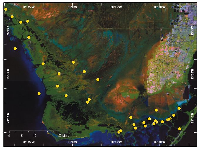 |
| Figure 1. Location of U.S. Geological Survey estuarine and wetland hydrologic monitoring stations in Everglades National Park, South Florida. |
The network of monitoring stations (fig. 1) collects information at points of interest that represent major flow paths from the Everglades wetlands to the estuaries. Combining data collected throughout the network assures that hydrologic information will be available (from upstream to downstream) across 10 generalized coastal gradients or river/creek systems (fig. 2).
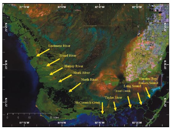 |
| Figure 2. Monitoring stations located within 10 generalized coastal transects. Arrows represent coastal transects. |
In addition to data collected from the monitoring stations, moving boat surveys are performed along these 10 generalized transects to collect salinity, water temperature, and geographic location data. Results of a salinity survey made on March 30, 2004, are shown in figure 3 . Salinity is in parts per thousand (ppt).
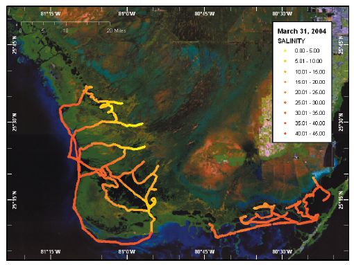 |
| Figure 3. Salinity survey made on March 31, 2004. |
Acoustic Doppler Velocity Meters (ADVMs) are used to collect time-series water-velocity data. Velocities measured by these units (index velocities) are directly proportional to the mean cross-sectional velocity for the stream, and are used in conjunction with Acoustic Doppler Current Profiler (ADCP) measurements to develop calibration ratings for the computation of discharge. Index velocity is the predominant variable, and in most instances, the only variable needed to describe the relation to the mean measured velocity. Stage is occasionally needed as a secondary variable, or "modifier" of the velocity relation. The relation between the ADVM index velocity (X axis) and the ADCP mean measured velocity (Y axis) developed for the Chatham River monitoring station is shown in figure 4.
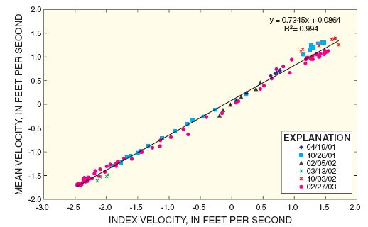 |
| Figure 4. Velocity index rating for Chatham River (located north of Lostmans River). |
Continuous salinity data from the main rivers and along transects from freshwater wetlands to estuaries will be useful for describing the spatial and temporal variation of salinity throughout the study area. The data also will help scientists and managers determine how salinity patterns may change in response to restoration efforts that affect freshwater deliveries to the Everglades. Figure 5 displays salinity patterns along the southwestern coast of ENP.
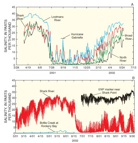 |
| Figure 5. Salinity values for selected rivers along the southwestern coast of Everglades National Park. |
Trends in the magnitude and distribution of flows between creeks can readily be distinguished (fig. 6). Mean monthly values of discharge data for northeastern Florida Bay are shown in figure 6. Trends in the magnitude and distribution of flows between creeks are easily distinguishable.
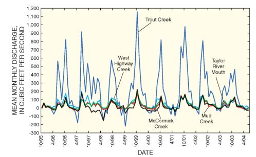 |
| Figure 6. Mean monthly values of discharge in northeastern Florida Bay. Positive values indicate flow into Florida Bay. |
Assuming that CERP modifications to water-delivery systems will attempt to reproduce historical hydroperiods more effectively than existing water-management practices, it is reasonable to expect an extended hydroperiod and shortened dry season during years of average rainfall. Data have been collected from the network since 1995, during a period when the southern estuaries have experienced a wide range of natural climatic conditions, including multiple tropical storms and hurricanes, and an El Ni�o event in 1998. Thus, the data gathered from the monitoring stations can be used to help determine whether changes observed in the ecosystem are the result of natural processes, CERP-related activities, or a combination of both.
Use of the historical and real-time data will benefit CERP in several ways:
In summary, a monitoring network spanning the major flow paths from the Everglades wetlands to the southern estuaries will help provide a system-wide understanding of the ecosystem responses occurring in the Everglades due to changes in water-management practices and climatic variability.
Clinton Hittle
U.S. Geological Survey Florida
Integrated Science Center
Water and Restoration Studies
9100 N.W. 36 St. Ste. 110
Miami Fla., 33179
Phone (305) 717-5815
E-mail: cdhittle@usgs.gov
Eduardo Patino
U.S. Geological Survey Florida
Integrated Science Center Water and Restoration Studies
3745 Broadway, Ste. 301
Ft. Myers, Fla. 33901
(239) 275-8448 ext. 11
E-mail: epatino@usgs.gov
Mark Zucker
U.S. Geological Survey Florida
Integrated Science Center
Water and Restoration Studies
9100 N.W. 36 St., Ste. 110
Miami Fla., 33179
Phone (305) 717-5815
E-mail: mzucker@usgs.gov
This report is available online in Portable Document Format (PDF). If you do not have the Adobe Acrobat PDF Reader, it is available for free download from Adobe Systems Incorporated.
Download the report (PDF, 3.7 MB)
Document Accessibility: Adobe Systems Incorporated has information about PDFs and the visually impaired. This information provides tools to help make PDF files accessible. These tools convert Adobe PDF documents into HTML or ASCII text, which then can be read by a number of common screen-reading programs that synthesize text as audible speech. In addition, an accessible version of Acrobat Reader 5.0 for Windows (English only), which contains support for screen readers, is available. These tools and the accessible reader may be obtained free from Adobe at Adobe Access.
| AccessibilityFOIAPrivacyPolicies and Notices | |
 |
|