Fact Sheet 2005-3018
March 2005
This factsheet is available as a pdf.
| This Fact Sheet is one in a series that highlights information or recent research findings from the USGS National Streamflow Information Program (NSIP). The investigations and scientific results reported in this series require a nationally consistent streamgaging network with stable long-term monitoring sites and a rigorous program of data quality assurance, management, archiving, and synthesis. NSIP produces multi-purpose, unbiased surface water information that is readily accessible to all. |
Mountain snow fields act as natural reservoirs for many western water-supply systems, storing precipitation from the cool season, when most precipitation falls and forms snowpacks, until the warm season when most or all snowpacks melt and release water into rivers. As much as 75 percent of water supplies in the western United States are derived from snowmelt. Thus, water-resource management of western rivers commonly is planned around the knowledge that much of the runoff to reservoirs and lowlands occurs during the early parts of the warm season, when water demands for irrigation and other uses are at their greatest. During the cool season, water demands are low and, in West Coast states, the potential is high for winter storms to cause disastrous floods. Separation in time between the cool-season risks of flooding and the warm-season benefits of snowmelt runoff is a fundamental assumption of water-resource management strategies in the West.
Trends toward diminished snowpack and earlier snowmelt in western states may be related to global warming (Knowles and Cayan, 2002; Mote, 2003; Stewart and others, 2004) or to naturally occurring variability in winter and spring temperatures and in precipitation form or timing (Dettinger and Cayan, 1995; Cayan and others, 2001). These changes also affect streamflow timing (Dettinger and Cayan, 1995; Cayan and others, 2001). Trends toward earlier snowmelt and streamflow, whatever the causes, threaten finely tuned water-resource and flood-management systems and procedures in many western settings. Therefore recently observed trends toward earlier snowmelt and streamflow in western rivers measured by the U.S. Geological Survey (USGS) are a source of considerable interest and concern to resource managers.
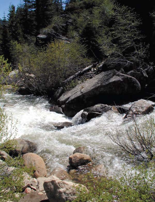 |
| Tumultuous springtime snowmelt-fed streamflow in the eastern Sierra Nevada, East Fork of the Carson River above Grovers Hot Springs, Markleeville, California, May 2000. |
Benjamin Franklin observed that "When the well is dry, we learn the worth of water." A similar sentiment applies to the availability of information on water, particularly information on streamflow magnitude and timing. Streamflow information is required for numerous water-facility design and operational needs, as well as for research bearing on the long-term implications of climate variability and human activities. The USGS has been measuring and recording streamflows in the western United States since the late 19th century. Because USGS streamflow data (http://waterdata.usgs.gov/usa/nwis/sw) are collected to consistent national standards, span long periods of time, cover the full range of streamflow from floods to droughts, and include observations for unregulated natural streams, they can be analyzed to determine when and where snowmelt and streamflow-timing vary.
Streamflow timing can be described by many different measures, depending on data availability and on the aspects of streamflow timing that are of most concern. Roos (1991) and Dettinger and Cayan (1995) analyzed the fractions of annual streamflow that occur in spring and summer seasons, because this fraction of total flow is, in many water-resource systems, the most readily stored and distributed for warm-season uses. Cayan and others (2001) characterized streamflow timing by the day of year when wintertime low-flow conditions rapidly transition to springtime high-flow conditions with the onset of warm-season snowmelt. These "spring-pulse dates" are important because they indicate the timing of snowmelt and the divide between winter and spring conditions. Stewart and others (2004) characterized streamflow timing by the "center of volume" of each year's hydrograph. The center-of-volume date is the date by which roughly half of the streamflow for a year has passed. These center-of-volume dates provide direct measures of overall streamflow timing based on runoff conditions throughout the year.
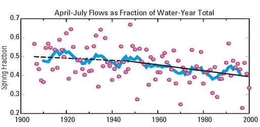
Annual streamflow in most western rivers has come progressively earlier during the past several decades. The long-term tendency of springtime streamflow (that fraction of overall flow that occurs from April to July) to decline during the 20th century in the central and northern Sierra Nevada is shown as a fraction of overall flow in figure 1. Regressions of data prior to the 1945 indicate no statistically significant trend, whereas regression of data after 1945 show a clear statistically significant trend toward earlier streamflow. As the springtime fractions of yearly flows have declined, the fraction in winter, and especially flows in March, have increased. These results broadly reflect a regional trend toward warmer winters and springs during the same period (fig. 2).
|
| Figure 1. April - July streamflow in eight major rivers of the western Sierra Nevada, California, as a fraction of water-year (October through September) total streamflow. Dots indicate yearly values, blue curve is 9-year moving averages, and dashed line is linear trend prior to 1945 and solid line is trend after 1945. |
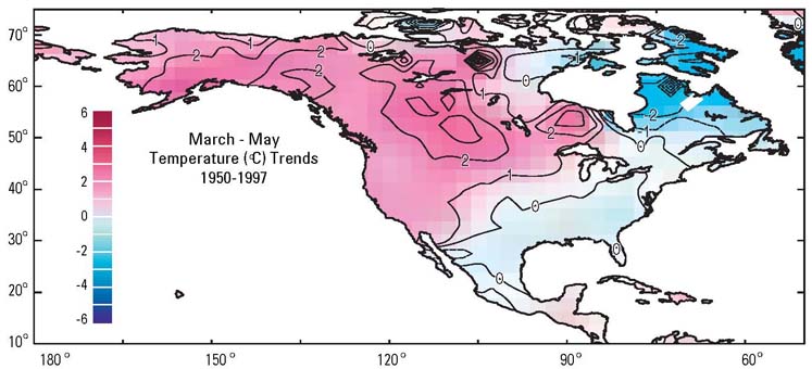 |
| Figure 2. Springtime temperature trends in North America, 1950-1997, using gridded temperature anomalies from Peterson and Vose (1997). |
Changes in daily streamflow variations and center-of-volume dates of western rivers can be illustrated by comparing mean measured flows in the Clark Fork Yellowstone River, Wyoming, during the 1950s with those during the 1990s (fig. 3a). The overall river discharges in these two decades were quite similar, with average flow rates of 27.8 cubic meters per second in the 1950s and 27.9 in the 1990s. In the 1990s, however, springtime flows were larger and late summer flows were smaller than in the 1950s. Thus, flow generally arrived earlier in the 1990s than in 1950s, with an average center-of-volume date that was about 4 days earlier in the 1990s than in the 1950s. The year-by-year history of center-of-volume dates for the Clark Fork Yellowstone River is shown in figure 3b, illustrating the general trend towards earlier flows in the river before, and especially after about 1950.
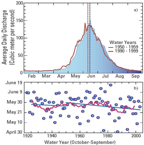 |
| Figure 3. (a) Comparison of mean daily streamflows in the Clark Fork Yellowstone River, Wyoming, during the 1950s and 1990s, and (b) center-of-volume dates for each year from 1922 to 2003, with the red curve showing the 9-year moving average and straight lines showing the trend before and after 1950. |
The geographic extent of the trends toward earlier streamflow in snow-fed streams is shown in figure 4, with timing measured by the dates on which the snowmelt runoff adds a large initial surge to the rivers (fig. 4a) across the western conterminous states and by the center-of-volume dates in rivers throughout western North America (fig. 4b). Both measures indicate that flows in many western streams arrive a week to almost 3 weeks earlier now than they did in the middle of the 20th century. The largest changes have been identified in the Pacific Northwest, but the trends also are present in the Sierra Nevada of California, in the Rocky Mountains, and through parts of British Columbia and southern Alaska.
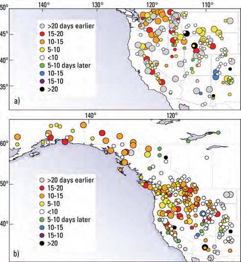 |
| Figure 4. Trends in (a) yearly dates of spring snowmelt onset and (b) centers of volume of yearly streamflow hydrographs in rivers throughout western North America, based on U.S. Geological Survey streamgages in the United States and an equivalent Canadian streamflow network. Large circles indicate sites with trends that differ significantly from zero at a 90-percent confidence level; small circles are not confidently identified. |
The regional trend in streamflow timing developed in the midst of large year-to-year and basin-to-basin variations in both streamflow amounts and timing. The variations are due to contrasts in topographies, precipitation patterns, and snow conditions among the river basins. Trends toward later streamflow were detected in a few western rivers. Despite the basin-to-basin and year-to-year differences, however, over 90 percent of the stations with statistically significant trends in figure 4 have trended toward earlier runoff, signaling the breadth and strength of the regional trend in western states. The average center-of-volume date for rivers across the western United States is about 9 days earlier now than in the 1950s.
These trends in timing are most readily attributed to winter and spring warming, as depicted in figure 2, but that interpretation is complicated by recent trends toward more (or less) precipitation in some areas and by a broad trend towards slightly later precipitation. The causes of these long-term climatic trends remain uncertain. The observed streamflow timing and winter-spring warming trends are consistent with current projections of how greenhouse effects may influence western climates and hydrology; thus streamflow timing and trends may be attributed, in part, to global warming. The climate of the North Pacific Ocean basin, however, underwent a seemingly natural change toward warmer conditions in the eastern Pacific and western Americas around 1977 (Mantua, and others, 1997). This multidecadal change was part of a long-term cycle of climate fluctuations in the region and to an uncertain extent, has contributed to long-term climatic and hydrologic changes in the western states during the past 50 years. Continued and even enhanced streamflow monitoring and analysis of western snow-fed rivers will be needed to determine the precise natural and human-induced causes, and the likely future, of these western streamflow-timing trends. If the trends have natural origins, then they may well reverse themselves, but if they are driven by man-made influences on the climate system, the streamflow timing may continue to change. If the trends continue their present course, then the "natural reservoirs" provided by western snowfields will become progressively less useful for water-resources management, flood risks may change in unpredictable ways, and many mountain landscapes will endure increasingly severe summer-drought conditions.
For additional information:
Michael Dettinger
U.S. Geological Survey
Scripps Institution of Oceanography
9500 Gilman Drive, Dept. 0224
La Jolla, CA 92093-0224
(858)822-1507 or mddettin@usgs.gov
Cayan, D.R., Kammerdiener, S., Dettinger, M.D., Caprio, J.M. and Peterson, D.H., 2001, Changes in the onset of spring in the western United States: Bull. Amer. Meteor. Soc. 82, 399-415.
Dettinger, M.D. and Cayan, D.R.,1995, Large-scale atmospheric forcing of recent trends toward early snowmelt in California: J. Clim. 8, 606-623.
Knowles, N. and Cayan, D., 2002, Potential impacts of climate change on the Sacramento/San Joaquin watershed and the San Francisco estuary: Geophysical Research Letters 29, No. 18, 1891, doi:10.1029/2001GL014339.
Mantua, N.J., Hare, S.R., Zhand, Y., Wallace, J.M., and Francis, R.C., 1997, A Pacific interdecadal climate oscillation with impacts on salmon production: Bull. Amer. Meteor. Soc., 78, p. 1069-1079.
Mote, P.W., 2003, Trends in snow water equivalent in the Pacific Northwest and their climatic causes. Geophysical Research Letters, 30, DOI 10.1029/2003GL0172588.
Peterson, T.C., and Vose, R.S., 1997, An overview of the Global Historical Climatology Network temperature data base: Bull. Amer. Meteor. Soc., 78, 2837-2849.
Roos, M., 1991, A trend of decreasing snowmelt runoff in northern California: Proc., 59th Western Snow Conference, Juneau, AK, 29-36.
Stewart, I., Cayan, D.R., and Dettinger, M.D., 2004, Changes in snowmelt runoff timing in western North America under a "Business as Usual" climate change scenario: Climatic Change 62, 217-232.
This factsheet is available online in Portable Document Format (PDF). If you do not have the Adobe Acrobat PDF Reader, it is available for free download from Adobe Systems Incorporated.
Download the report (PDF,739KB)
Document Accessibility: Adobe Systems Incorporated has information about PDFs and the visually impaired. This information provides tools to help make PDF files accessible. These tools convert Adobe PDF documents into HTML or ASCII text, which then can be read by a number of common screen-reading programs that synthesize text as audible speech. In addition, an accessible version of Acrobat Reader 5.0 for Windows (English only), which contains support for screen readers, is available. These tools and the accessible reader may be obtained free from Adobe at Adobe Access.
| AccessibilityFOIAPrivacyPolicies and Notices | |
 |
|