
Assessing the Vulnerability of Public-Supply Wells to Contamination from Urban, Agricultural, and Natural Sources
By Sandra M. Eberts, Martha L. Erwin, and Pixie A. Hamilton
U.S. Department of the Interior
U.S. Geological Survey
Fact Sheet 2005-3022
A pdf is available for this fact sheet
What are the most important factors controlling contamination of public-supply wells,
and how can we do a better job of predicting their vulnerability to contamination?
In 2001, the U.S. Geological Survey’s National Water-Quality Assessment (NAWQA) Program began an intensive
study to assess the vulnerability of public-supply wells to contamination from a variety of compounds.
The study builds on previous NAWQA studies from 1991 to 2001 that found low levels of mixtures of
contaminants in ground water near the water table in urban areas across the Nation (in about 90
percent of monitoring wells) and, less frequently, in deeper ground water typically developed
for public supply (Hamilton and others, 2004). Data from more than 1,000 public-supply wells
within major water-supply aquifers are being evaluated in this study, and data from more aquifers
and wells are scheduled to be added in 2009 (see map, p. 4).
This NAWQA study is focusing on the transport and chemical breakdown of selected anthropogenic contaminants
from urban and agricultural sources, as well as contaminants from natural sources, within that part of the
ground-water system contributing water to public-supply wells. Scientists are investigating how the
linkage between contaminant sources and public-supply wells is affected by processes that occur below
land surface—whereby contaminants are mobilized, dispersed, diluted, volatilized, adsorbed, and
(or) degraded. Scientists are also investigating how the operation of public-supply wells can affect
their vulnerability to contamination.
Because subsurface processes and management practices differ among aquifers and public-water systems, public-supply
wells in different parts of the Nation are not equally vulnerable to contamination, even
where similar contaminant sources exist. The study is identifying these important differences,
as well as similarities, in a complementary set of aquifer systems, urban settings, and public-water systems.
A national priority, a scientific challenge
About one-third of the U.S. population gets drinking water from public-supply wells.
The occurrence of contaminants in these wells is highly variable (U.S. Environmental Protection
Agency, 1999). To safeguard public health, we need a better understanding of how these wells
can become contaminated.
Understanding public-supply well contamination is also an economic issue because
cleaning up contaminated ground water is expensive and difficult. Drinking water
from public-supply wells must meet U.S. Environmental Protection Agency (USEPA)
and (or) State water-quality standards. Vulnerability assessments based on sound
science will help decision-makers predict which wells are vulnerable
to contamination and design strategies to prevent future contamination,
thereby sustaining the water supply.
Vulnerability assessments, however, are inherently uncertain. Scientists do
not fully understand contaminant behavior in the subsurface, and there are limitations
in the databases and models used to perform the assessments (National Research
Council, 1993). An additional challenge is the need to strike a balance between
complex, costly assessments and those that are oversimplified (Focazio and others,
2002). As a result, ground-water vulnerability has been assessed using many
different methods (Nolan, 1998); most of the previous assessments have focused
on the transport of contaminants to the water table rather than to public-supply
wells.
Contaminants assessed in this study
- Anthropogenic contaminants, including nitrate, pesticides
and their breakdown products (such as atrazine and deethylatrazine),
compounds found in wastewater; and volatile organic compounds (such
as MTBE and disinfection by-products)
- Naturally occurring contaminants, including arsenic,
uranium, radon, and radium
- Fecal contamination, using indicators such as E.
coli and total coliform (bacteria) and coliphage (a group of
viruses)

|
In the current study, we address the challenges of vulnerability assessments
by collecting and analyzing similar data within a variety of settings, including
unique data collected using new tools. We are developing a library of site-specific
models to help sort out the most important factors to include in vulnerability
assessments in different settings at both regional and local scales.
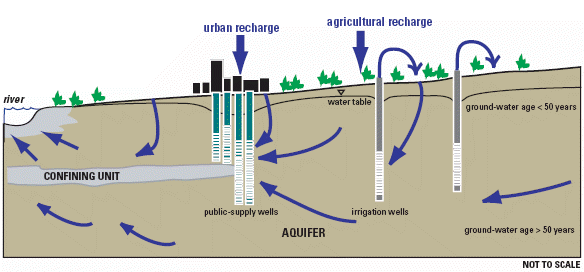 |
| An aquifer system and public-water system in an urban
setting. The water entering the well screens of the public-supply wells
is of different ages and from different areas because of their long screened
intervals, which commonly make public-supply wells vulnerable to contamination
from multiple sources. In this example, sources of contaminants may include
those associated with urban and agricultural land-use activities. Aquifer
materials may also serve as sources of natural contaminants such as arsenic. |
Study results will provide a foundation for assessing the vulnerability of the Nation’s
public-supply wells to a variety of contaminants, and will help those involved in well siting
and water-quality protection anticipate the response of different systems to changes in management practices.
The results also will be useful to those involved in planning and implementing State source-water assessment
and protection programs, as guided by the USEPA (U.S. Environmental Protection
Agency, 1997).
General objectives of the study
- Identify the dominant contaminants and sources of those contaminants in public-supply wells in representative
water-supply aquifers across the Nation
- Assess the effects of natural processes
(such as degradation) and human activities (such as irrigation) on the occurrence of contaminants in public-supply wells in representative
aquifers
- Identify the factors that are most important to incorporate into public-supply well vulnerability
assessments in different settings and at different spatial scales
- Develop simple methods and models for screening public-supply wells for vulnerability to contamination
in unstudied areas and from newly emerging contaminants
- Increase understanding of the potential effects of water-resource development and management decisions on
the quality of water from public-supply wells
|
Ground-water vulnerability—the
likelihood that contaminants will reach a specified reference location
in a ground-water system (the water table, deep within the aquifer, a
public- supply well, the interface between ground and surface water) (National
Research Council, 1993).
Area contributing recharge—the surface area at the water table or a surface-water body from which water entering the ground-water system eventually flows to the well. Estimates
of areas contributing recharge to public-supply wells are made in order to target ground-water protection
practices (Franke and others, 1998).
Ground-water age—the time elapsed (ranging from days to millennia)
since water reached the water table during recharge. Young ground water tends to be more susceptible to
contamination from current sources at the land surface than older ground water (Focazio and others, 2002).
Water discharging from a well is usually a mixture of waters of different ages.
Ground-water sustainability—the development and use of
ground-water resources in a manner that can be maintained indefinitely without unacceptable consequences
(Alley and Leake, 2004). Water quality and water quantity are equally critical for the long-term sustainability
of the Nation’s water supply (U.S. Geological Survey, 2002). |
Unique characteristics of the study
Sampling at different depths
The screened or open intervals of public-supply wells are commonly from tens to hundreds of feet in
length; therefore, water from these wells is generally a mixture of waters of different
ages that enter the well at different depths and are associated with different
potential sources of contamination. The graphic on this page illustrates a situation
where recharge to public-supply wells reflects urban and agricultural
land-use activities. Specifically, water recharges the aquifer in the urban area
containing urban-related contaminants, such as volatile organic compounds, and enters
the well screens above water that has traveled from the more distant agricultural area
where recharge water may contain contaminants such as agricultural pesticides.
Using a USGS-developed sampler (Izbicki, 2004), we are collecting samples at
multiple depths in pumping public-supply wells to ascertain where and how contaminants
from different sources enter the wells. For example, samples collected from
public-supply wellheads and analyzed for concentrations of multiple contaminants
are being “dated” to determine ground-water age and compared to samples and
ages of water entering the wells at various depths (see graph below). This analysis
is helping to evaluate the usefulness of ground-water age samples from wellheads
for predicting the risk of contamination.
Evaluating multiple settings and scales
Consistent methods are being used to collect and analyze data, and investigations
are being conducted at both regional (tens to thousands of square miles) and local scales
(less than 10 square miles). We can therefore compare and contrast results and identify the
most important processes to include in vulnerability assessments applied at different scales
and in a variety of water-supply aquifers. For example, nitrate is detected in ground water
in most participating study areas. The distribution and concentration
of nitrate between the water table and public-supply wells are controlled predominantly
by dilution in some areas and by dispersion or degradation in others. Using models developed
for each study area, we are exploring how these differences in subsurface processes
affect the response of different aquifer systems to common management practices.
Exploring the consequences of uncertainty
To make informed decisions about activities at a particular location, decision-
makers need to know whether the location is contributing recharge to public-supply wells.
They also need information about traveltimes between potential contaminant sources and
public-supply wells. Because this information cannot be measured directly, decision-makers
must rely on estimates that are inherently uncertain (due to limitations in the methods).
We are exploring the consequences of this uncertainty, and helping decision-makers understand
these consequences, by comparing estimates from traditional and probabilistic modeling approaches
with actual water-quality data from public-supply wells.
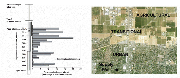 |
| Inflow at different depths within a public-supply well.
The aerial photo shows an approximately 63-square-mile area near the well.
Water entering the well screen is associated with different potential sources
of contaminants because of the different land-use activities in the areas
contributing recharge to various intervals along the well screen, as well
as the different aquifer materials through which water flows between the
recharge areas and the well. The amount of contamination that might be contributed
by any given interval is related to the volume of water that flows into
the well along the interval and the concentration of any associated contaminants.
Depth-dependent samples are a composite of all intervals beneath the sampling
point; these samples are being analyzed for chemical quality and ground-water
age and then compared to samples collected from the wellhead. |
How this information can be used
Study results, models, and other decision-
support tools will apply to broad classes of contaminants, including newly identified, emerging contaminants,
and will help water managers and scientists:
- Better understand how and why contamination of public-supply wells occurs
- Improve assessments of the vulnerability of ground water and public-supply wells to
contamination, even in unmonitored areas
- Choose new sites for water supply and develop and prioritize monitoring programs
- Evaluate various resource-development and management scenarios.
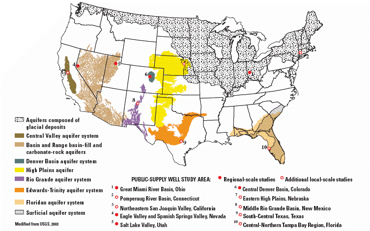 |
| Locations of regional-scale studies of public-supply well vulnerability to contamination from urban,
agricultural, and natural sources. Studies began in 2001 in eight States, in Texas and New Mexico in 2005,
and are scheduled for Illinois and New Jersey or New York in 2009. |
Contacts
Sandra Eberts, Team Leader
(614) 430-7740, smeberts@usgs.gov
Mary Ann Thomas, Ohio
(614) 430-7736 mathomas@usgs.gov
Craig Brown, Connecticut
(860) 291-6766 cjbrown@usgs.gov
Karen Burow, California
(916) 278-3087 krburow@usgs.gov
Michael Rosen, Nevada
(775) 887-7683 mrosen@usgs.gov
Bernard Stolp, Utah
(801) 908-5061 bjstolp@usgs.gov
Suzanne Paschke, Colorado
(303) 236-4882 ext 352 spaschke@usgs.gov
Matthew Landon, Nebraska
(402) 328-4125 landon@usgs.gov
Laura Bexfield, New Mexico
(505) 830-7972 bexfield@usgs.gov
Lynne Fahlquist, Texas
(512) 927-3508 lfahlqst@usgs.gov
Christy Crandall, Florida
(850) 942-9500 ext 3030 crandall@usgs.gov
References
Alley, W.M., and Leake, S.A., 2004, The
journey from safe yield to sustainability: Ground Water, v. 42, no. 1, p. 12-16.
Focazio, M.J., Reilly, T.E., Rupert, M.G., and Helsel, D.R., 2002, Assessing ground-water vulnerability to contamination–Providing scientifically
defensible information for decision makers: USGS Circular 1224, 33 p.
Franke, O.L., Reilly, T.E., Pollock, D.W., and LaBaugh, J.W., 1998, Estimating areas contributing
recharge to wells–Lessons from previous studies: USGS Circular 1174, 14 p.
Hamilton, P.A., Miller, T.L., and Myers, D.N., 2004: Water quality in the Nation’s streams and
aquifers–Overview of selected findings, 1991-2001: USGS Circular 1265, 20 p.
Izbicki, J.A., 2004, A small-diameter sample pump for collection of depth-dependent samples
from production wells under pumping conditions: USGS Fact Sheet 2004-3096, 2 p.
National Research Council, 1993, Ground-water vulnerability assessment–Predicting
relative contamination potential under conditions of uncertainty: Washington, D.C., National Academy
Press, 204 p.
Nolan, B.T., 1998, Modeling approaches for assessing the risk of nonpoint-source contamination
of ground water: USGS Open File Report 98-531, 15 p.
U.S. Environmental Protection Agency, 1997, State source water assessment and protection programs–Final
guidance: USEPA Office of Water, EPA 816-R-97-009.
U.S. Environmental Protection Agency, 1999, A review of contaminant occurrence in public water systems:
USEPA Office of Water, EPA 816-R-99-006, 78 p.
U.S. Geological Survey, 2002, Report to Congress,
concepts for national assessment of water availability and use: USGS Circular 1223, 34 p.
U.S. Geological Survey, 2003, Principal aquifers of the 48 conterminous
United States, Hawaii, Puerto Rico, and the U.S. Virgin Islands, available online
at http://www.nationalatlas.gov/mld/aquifrp.html
The
NAWQA Program
The study of public-supply well vulnerability is one of
five national priority topics being addressed by the NAWQA Program in
its second decade, which began in 2001. Other topics include effects of
urbanization on stream ecosystems; ecological effects of nutrient enrichment;
mercury in stream ecosystems; and sources, transport, and fate of agricultural
chemicals. In addition, anthropogenic organic contaminants in source waters
for many of the Nation’s largest community water systems are being assessed;
concentrations in source waters are being compared to concentrations in
finished waters. During the Program’s first decade, NAWQA scientists assessed
surface- and ground-water chemistry, stream hydrology, habitat, and biological
communities in 51 major river basins (“Study Units”; see map at http://water.usgs.gov/nawqa).
Baseline assessments of pesticides, nutrients, VOCs, trace elements, dissolved
solids, and radon, and of the condition of aquatic habitats and fish,
insect, and algal communities are described in hundreds of reports, available
at the Web site above. Reassessments planned in 42 of the Study Units
in the Program’s second decade will determine trends at many of the streams
and ground-water sites; fill critical gaps in the characterization of
water quality; and build upon findings that show how natural features
and human activities affect water quality and aquatic ecosystems. |
This report is available online in Portable Document Format (PDF). If you
do not have
the Adobe
Acrobat PDF Reader, it is available for free download from Adobe Systems
Incorporated.
Download the report (PDF, 1.3 MB)
Document Accessibility: Adobe Systems Incorporated has information about PDFs
and the visually impaired. This information provides tools to help make PDF
files accessible. These tools convert Adobe PDF documents into HTML or ASCII
text, which then can be read by a number of common screen-reading programs
that synthesize text as audible speech. In addition, an accessible version
of Acrobat Reader 5.0 for Windows (English only), which contains support for
screen readers, is available. These tools and the accessible reader may be
obtained free from Adobe at Adobe
Access.
Top
