
|
The Humboldt River Basin in northern Nevada is the third largest producer of gold in the world and the largest producer of silver in the conterminous United States. The U.S. Geological Survey (USGS) has recently completed a mineral resource assessment of the basin and northern Nevada that indicates that many areas in the region may contain signifi cant undiscovered gold and silver deposits. |
The Humboldt River Basin in northern Nevada has been one of the Nation's and the world's important sources of gold, silver, copper, mercury, and tungsten. It covers approximately 16,600 square miles (43,000 km2) of arid to semiarid land, much of which is publicly owned and administered by the U.S. Bureau of Land Management (BLM). Minerals-related activities, including mineral exploration, are among the multiple uses of these lands.
U.S. Geological Survey (USGS) scientists have recently completed and published a major assessment of metallic mineral resources in the Humboldt River Basin and adjacent areas of northern Nevada (USGS Bulletin 2218, online at https://pubs.usgs.gov/bul/b2218/). This report identifies large areas of the region that may contain undiscovered metallic mineral deposits and that may be suitable as sites for future mining activities. These results can be integrated into BLM's long-term land-use planning for the Humboldt River Basin.
The USGS assessment primarily focused on gold and silver deposits, which are the metallic minerals most likely to be explored for and mined in the Humboldt River Basin region in the foreseeable future. The assessment used a combination of expert knowledge and data-driven (Geographic Information System (GIS) based) methods to evaluate the potential for major undiscovered deposits in the region. In the report, the results of the assessment are portrayed on three maps of the region, along with extensive accompanying descriptions.
 |
|
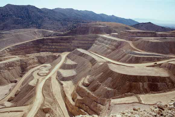
The Coeur Rochester mine in the Humboldt River Basin is the largest operating silver mine in the conterminous United States. The silver-rich ores are being mined with open-pit methods, which is a common technique for mining silver and gold in the region. In 2003, mining in Nevada produced $50 million of silver (56% of U.S. con- sumption) and $2.7 billion of gold (82% of U.S. production). (USGS photograph by Alan R. Wallace.) |
The USGS assessment of the Humboldt River Basin region indicates that large areas of the region may contain significant undiscovered metallic mineral deposits. These deposits fall into three broad categories:
• Pluton-related polymetallic deposits form during the intrusion of magma into rocks in the upper crust. Pluton-related systems typically are very large and can contain a wide variety of deposits and metals. The USGS assessment of the Humboldt River Basin demonstrates that seven northeast- and northwest-trending belts may contain large undiscovered pluton-related deposits. All of the belts have known pluton-related deposits of various types, and mining industry efforts will likely focus on many areas in these belts over the next 10 to 15 years.
• Sedimentary rock-hosted gold-silver deposits are the most economically important types of gold-bearing deposits in northern Nevada, and they are being mined along five major belts of mineral deposits in the region. These deposits commonly formed in limestones and other carbonate-bearing rocks of Paleozoic age (570 to 245 million years old) and fall into two categories with distinct origins and different gold:silver ratios–(1) distal-disseminated deposits and (2) Carlin-type deposits. The USGS assessment indicates that undiscovered sedimentary rock-hosted deposits of both types may be present along extensions of the five known belts and in six additional areas outside of these zones.
• Epithermal gold-silver deposits form within about a mile (2 km) of the Earth's surface as a result of magmatically heated water leaching minerals from adjacent rock and then rising to deposit them as veins within fissures and faults and as disseminations in the adjacent rocks. In addition, high regional heat flow in northern Nevada has produced geologically young epithermal deposits related to fossil and active geothermal systems. The USGS assessment shows that undiscovered epithermal gold-silver deposits may be present in much of the western three-quarters of the Humboldt River Basin, an area that currently is under active scrutiny by the mineral industry.

|
|
(Click the map for a larger version.) U.S. Geological Survey (USGS) scientists recently finished a major assessment of metallic mineral resources in the Humboldt River Basin (purple outline) and adjacent areas of northern Nevada. The assessment indicates the likely existence of major undiscovered gold and silver deposits in the region. These deposits fall into three general categories-(1) pluton-related polymetallic deposits, (2) two types of sedimentary rock-hosted gold-silver deposits, and (3) epithermal gold-silver deposits. More than 10,000 square miles (26,000 km2) of northern Nevada could contain undiscovered pluton-related and (or) sedimentary rock-hosted deposits, and more than 12,000 square miles (31,000 km2) of the Humboldt River Basin may contain undiscovered epithermal deposits. |
The USGS regional assessment of metallic mineral resources in the Humboldt River Basin shows that the basin and surrounding areas of northern Nevada likely contain significant undiscovered gold and silver deposits. These deposits may be present within and outside of established mining districts, and new discoveries are continuing to be made as exploration methods and mineral-deposit-genesis concepts evolve.
Economics ultimately will determine if future mines will be developed in the Humboldt River Basin. The duration of mining in any particular area may be continuous or episodic, and centers of mining-related activity may shift dramatically over time. Consequently, the role of mining-related activities in land-use planning is dynamic and not restricted in time and place. The results of this assessment indicate areas where these future mining activities may take place.
Meeting the challenge of supplying America's needs for nonrenewable resources requires accurate and unbiased scientific data. The ongoing work of scientists with the USGS Mineral Resources Program in Nevada and elsewhere in the United States provides the information crucial to the creation of sound policies that will ensure future supplies of mineral resources.
By Alan R. Wallace, Steve Ludington, Mark J. Mihalasky, Stephen G. Peters, Ted G. Theodore, David A. Ponce, David A. John, and Byron R. Berger, with contributions from Michael L. Zientek, Gary B. Sidder, and Robert A. Zierenberg.
Edited by James W. Hendley II
Graphic design by Sara Boore and Susan Mayfield
Web design by Michael Diggles
COOPERATING AGENCY
U.S. Bureau of Land Management
For further information contact:
Alan R. Wallace
U.S. Geological Survey, MS 176
University of Nevada, Reno
Reno, NV 89557-0047
(775) 784-5789
URL http://minerals.usgs.gov/west/
For the complete assessment see: Wallace, A.R., Ludington, S., Mihalasky, M.J., Peters, S.G., Theodore, T.G., Ponce, D.A., John, D.A., and Berger, B.R., 2004, Assessment of metallic mineral resources in the Humboldt River Basin, northern Nevada, with a section on Platinum-group-element (PGE) potential of the Humboldt mafic complex by Zientek, M.L., Sidder, G.B., and Zierenberg, R.A.: U.S. Geological Survey Bulletin 2218, 1 CD-ROM
[ URL: https://pubs.usgs.gov/bul/b2218/ ]
PDF version of this 2-page fact sheet (fs2005-3023.pdf; 216 KB)
Download a copy of Acrobat Reader for free
| Help | PDF help | Western Publications main page | Western Fact Sheets |
| Department of the Interior
| Privacy Statement | Disclaimer
| Accessibility |
URL of this page: https://pubs.usgs.gov/fs/2005/3023/
Maintained by: Michael Diggles
Created: June 16, 2005
Last modified: June 20, 2005 (mfd)