 |
|
|
||||
| PUBLICATIONS—Fact Sheet 2005–3111 |
Prepared in cooperation with the
U.S. Environmental Protection Agency and the City of Norman
By S. Jerrod Smith
Fact Sheet 2005–3111
This report is also available as a pdf.
In 2000, the U.S. Environmental Protection Agency (EPA) reviewed the arsenic drinking water standard for public water supplies. Considering the available research and statistics on the health effects of arsenic ingestion, the EPA reduced the Maximum Contaminant Level (MCL) for public drinking water from 50 micrograms per liter (μg/L) to 10 μg/L (U.S. Environmental Protection Agency, 2001a). As a result of the more stringent standard, the EPA estimates that about 3,000 public water providers across the United States must take action to meet the new standard before it becomes effective on January 23, 2006 (U.S. Environmental Protection Agency, 2001b).
The City of Norman (City) is one of several Oklahoma municipalities affected by the new arsenic standard. About 20 percent of Norman’s water is supplied by wells completed in the Central Oklahoma (Garber-Wellington) aquifer; the rest is supplied by Lake Thunderbird (fig. 1) or purchased from Oklahoma City. The Norman well field is composed of 24 active wells, and water produced from about half of the wells will not be in compliance with the new MCL (figs. 2 and 3). Chemical treatment of water with elevated arsenic is possible, but it is generally cost prohibitive. Another costly solution is simply to abandon the high-arsenic wells and replace them with new wells in low-arsenic areas. In the next phase of well construction beginning in 2005, the City plans to construct as many as 30 new wells in northeast Norman (Bryan Mitchell, City of Norman, oral commun., 2005). The new wells will replace production lost to the new arsenic standard and add new production to keep pace with rapidly growing consumer demand. Well modification to exclude arsenic-bearing water from existing wells is a more cost-effective solution, but it requires a great deal of knowledge about local aquifer properties and individual well dynamics to decide which wells are good candidates for modification. With the goal of determining if well modification can be used to bring some of Norman’s high-arsenic wells into compliance with the new arsenic standard, the EPA Office of Research and Development (ORD) initiated a three-year research project in 2003 with participation from the U.S. Geological Survey (USGS), Oklahoma State University, and the City of Norman. The primary objectives of the project are to: (1) determine where naturally occurring arsenic is entering wells by collecting water samples at different depths, (2) investigate the utility of new methods for collecting water-quality data in a pumping well, (3) better understand the stratigraphy and composition of aquifer rocks, (4) assess 10 wells for the possibility of arsenic remediation by well modification, and (5) evaluate the effectiveness of well modification in bringing marginal wells into compliance with the new arsenic MCL. The purpose of this report is to describe the occurrence of arsenic in ground water near Norman, Oklahoma, and available options for reducing arsenic concentrations in produced ground water.
 |
|---|
| Figure 1. Extent of the Central Oklahoma aquifer with well-head arsenic concentrations. The dark shaded part of the aquifer represents the part that is confined by the Hennessey Group. Deep municipal supply wells in the confined part are most likely to exceed the U.S. Environmental Protection Agency Maximum Contaminant Level for arsenic. |
 |
|---|
| Figure 2. Surficial geology and the city of Norman well field, 2003. |
 |
|---|
| Figure 3. Sample concentrations, median values, and drinking-water standards for arsenic in the Norman well field, 1984-2001. |
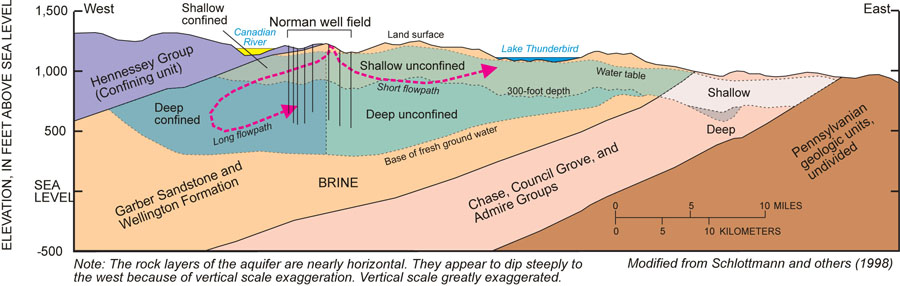
The City of Norman and many other municipalities in the Oklahoma City metropolitan area draw water from the Central Oklahoma aquifer. The aquifer underlies about 3,000 square miles in Cleveland, Lincoln, Logan, Oklahoma, Payne, Pottawatomie, and Seminole Counties (Parkhurst and others, 1996; fig. 1). It is commonly known as the Garber-Wellington aquifer because the greatest quantities of usable water are in the Garber Sandstone and Wellington Formation of Permian age (fig. 4). These rock units were deposited by an ancient river system and consist of discontinuous, interbedded channel bars (sandstones) and floodplain deposits (mudstones) (Stan Paxton and others, Oklahoma State University, written commun., 2005). The complex stratigraphy of the aquifer cre-ates a complex ground-water flow system and promotes chemical interactions between water and rock. The western part of the aquifer is confined or buried by the Permian-age Hennessey Group (fig. 1). Water in the confined part of the aquifer is generally more removed from recharge by precipitation than water in the uncon-fined part, so the effects of chemical interactions between water and rock are more prevalent.
 |
|---|
| Figure 4. Generalized hydrogeologic-section of the Central Oklahoma aquifer in the vicinity of Norman. The Norman well field produces water from the Garber Sandstone and Wellington formation in the deep confined and deep unconfined part of the aquifer. |
Small concentrations of arsenic occur naturally in nearly all rocks in the aquifer (Mosier, 1998), but only some areas show elevated concentrations (greater than 10 µg/L) in the water of the aquifer (fig. 1). Concentrations as great as 232 µg/L have been measured in the confined part of the aquifer in Norman (figs. 2 and 3). In other parts of the aquifer, arsenic concen-trations in water are so small that they are not detectable by current technology and methods. Several studies by the USGS and others have identified a tendency for elevated concentrations to occur in the western, confined part of the aquifer (fig. 1). City of Norman officials also recognized this trend and stopped drilling new wells in the western half of the City. Since 1990, Norman well-field expansion has been almost exclusively to the northeast of the City, and arsenic concentrations measured in these newer wells are typically less than the new MCL (figs. 2 and 3).
The processes and conditions that lead to elevated arsenic in the Central Oklahoma aquifer are well understood. Much of the understanding of the aquifer system arose from the U.S. Geological Survey National Water Quality Assessment (NAWQA) program. Several NAWQA studies, beginning in the late 1980s and concluding in the mid 1990s, determined the rock composition, water chemistry, and ground-water movement in the aquifer (Parkhurst and others, 1996; Breit, 1998; Mosier, 1998; Schlottmann and others, 1998). The findings of these studies led to a comprehensive con-ceptual model that is useful for explaining phenomena and patterns of arsenic concentrations observed in the field.
Ground-water flow in the southwestern part of the Central Oklahoma aquifer is driven by a potentiometric high centered in south-central Oklahoma County (Parkhurst and others, 1996; fig. 1). In the Norman area, short flowpaths travel to the southeast through Cleveland County and eventually discharge to the Little River drainage system. Other flowpaths travel to the southwest, descending under the confining unit before turning back to the east (Parkhurst and others, 1996; fig. 4). These flowpaths are longer, deeper, and slower, so water spends much more time in contact with aquifer materials.
In the Central Oklahoma aquifer, release of arsenic to ground water occurs when pH exceeds 8.5 standard units (fig. 5). The dominant geochemical processes that cause the increase in pH are cation exchange and dissolution of dolomite (Parkhurst and others, 1996). Along long flowpaths in the confined part of the aquifer (fig. 4), these processes can elevate the pH from nearly neutral (7.0) to greater than 8.5, at which point arsenic begins to desorb from aquifer mineral grains and reside in the water (Schlott-mann and others, 1998).
 |
|---|
| Figure 5. Relation between dissolved arsenic concentration and pH for wells in Cleveland County, Oklahoma, 1977-2004. |
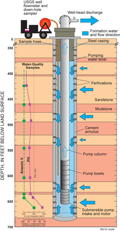
Concentrations of arsenic in water of the Central Oklahoma aquifer tend to increase with depth. Most private wells in central Oklahoma draw water from the shallow part of the aquifer, which is less than 300 feet below land surface (fig. 4). Shallow wells rarely produce water that exceeds the MCL, so arsenic is not a significant problem in domestic, stock, and irrigation wells. Most public-supply wells, on the other hand, produce water from the deep aquifer system (greater than 300 feet below land surface). Norman municipal wells, which are typically 600 to 800 feet deep, tap either the deep confined or deep unconfined aquifer system (fig. 4). Wells open to sandstone zones in the deep confined system (like those in western Norman) are more likely to exceed the arsenic MCL than wells completed in the unconfined system (Schlottmann and others, 1998). How-ever, arsenic concentrations in water are sometimes only elevated in one or two zones, usually near the bottom of the well (fig. 6). If these zones can be sealed off or isolated from production, the well will produce water with lesser concentrations of arsenic. The Central Oklahoma aquifer is ideal for this remediation strategy because contaminated sandstone zones are naturally separated or compartmentalized by relatively impermeable mudstone zones (fig. 6).
 |
|---|
| Figure 6. Depth-dependent sampling in Norman using the USGS well flowmeter and down-hole sampler in a hypothetical supply well. The dashed line connecting arsenic samples indicates no detection (ND) of the constituent. Note the iden-tification of an arsenic-contaminated zone at 665 feet below land surface. The bottom 30 feet of this well could be plugged to exclude contaminated water from produced water. |
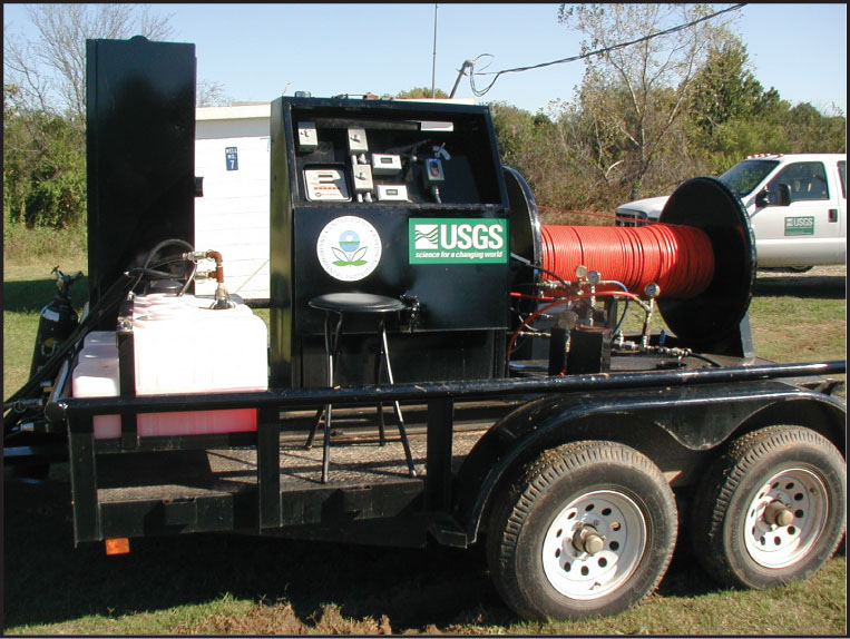
The best candidates for successful remediation are those wells that have marginal arsenic concentrations (slightly greater than 10 µg/L) and high water-production rates (greater than 200 gallons per minute). These wells are most likely to benefit from isolation of a single, high-arsenic zone and are the least likely to suffer from loss of production. To determine the changes in water contribution and contaminant concentrations at different depths in each well, the USGS is using a newly developed "well flowmeter and down-hole sampler" (Izbicki and others, 1999), referred to in this report as the down-hole sampler. The down-hole sampler can estimate the contribution of water from perforated zones and collect water samples at vari-ous depths in a pumping well (fig. 6). The USGS down-hole sampler is essen-tially a slim, high-pressure hose that can be raised and lowered between the pump column and well casing using a motorized hose reel (fig. 7). A line counter at the surface reports the depth of the hose outlet, which is equipped with check valves that allow water to enter but not exit the hose. The new method is considerably less expensive than standard methods of depth-dependent sampling, and it requires less down-time of the well. In terms of data quality, the greatest advantage of the USGS down-hole sampler is that all data collection is performed under true production conditions.
 |
|---|
| Figure 7. The USGS well flowmeter and down-hole sampler. Motorized hose reel with orange hose shown on the right. |
Based on data collected using the USGS down-hole sampler, EPA's Ground Water and Ecosystems Restoration Division in Ada, Oklahoma, and the City of Norman are evaluating two low-cost options for arsenic remediation in produced water. Because the USGS down-hole sampler has shown that greater arsenic concentrations tend to be found at deeper zones in a well, simply raising the pump intake may be an effective remediation strategy. If the pump intake is moved farther from the contaminated zone, the well may produce a lesser proportion of water from the contaminated zone. This simple strategy is advantageous because it is reversible, it may not sacrifice production, and it involves minimal down time for the well. However, this method may be just a temporary solution because the arsenic concentration in produced water may fluctuate with seasonal or prolonged changes in aquifer water levels.
Another remediation strategy is zonal isolation, which involves cementing in or plugging an arsenic-contributing zone. This strategy is advantageous because it ensures that a contaminated zone will no longer contribute any arsenic to the well. This technique is best suited for use in gun-perforated wells with a cement annulus, but it also could be applied in screened wells with a gravel-pack annulus. Zonal isolation also is best suited for use in aquifers where contributing zones are hydraulically separated by relatively impermeable units.
With the prospect of identifying individual wells for remediation using the USGS down-hole sampler, the City of Norman may be able to avoid the costly installation of some additional wells, conveyance infrastructure, and treatment technologies. Most importantly, the City may be able to decrease arsenic exposure to citizens and protect them against potentially unnecessary costs associated with treatment. Neighboring municipalities may eventually share the benefits of these new strategies for detecting and reducing contaminants in the Central Oklahoma aquifer. Furthermore, this understanding also may be transferable to other water suppliers in the United States that draw contaminated water from multilayered aquifers.
Breit, G.N., The diagenetic history of Permian rocks in the Central Oklahoma aquifer, in Christenson, S.C., and Havens, J.S., eds., Ground-water-quality assessment of the Central Oklahoma aquifer, Oklahoma-Results of investigations: U.S. Geological Survey Water-Supply Paper 2357-A, p. 45-70.
Izbicki, J.A., Christensen, A.H., Hanson, R.T., 1999, U.S. Geological Survey combined well-bore flow and depth-dependent water sampler: U.S. Geological Survey Fact Sheet, FS-196-99.
Mosier, E.L., Geochemical characterization of solid-phase materials in the Central Oklahoma aquifer, in Christenson, S.C., and Havens, J.S., eds., Ground-water-quality assessment of the Central Oklahoma aquifer, Oklahoma-Results of investigations: U.S. Geological Survey Water-Supply Paper 2357-A, p. 71-106.
Parkhurst, D.L., Christenson, S.C., and Breit, G.N., 1996, Ground-water-quality assessment of the Central Oklahoma aquifer, Oklahoma-Geochemical and geohydrologic investigations: U.S. Geological Survey Water-Supply Paper 2357-C, 101 p.
Schlottmann, J.L., Mosier, E.L., and Breit, G.N., 1998, Arsenic, chromium, selenium, and uranium in the Central Oklahoma aquifer, in Christenson, S.C., and Havens, J.S., eds., Ground-water-quality assessment of the Central Oklahoma aquifer, Oklahoma-Results of investigations: U.S. Geological Survey Water-Supply Paper 2357-A, p. 119-179.
U.S. Environmental Protection Agency, 1986, Maximum contaminant levels (subpart B of part 141, National interim primary drinking water regulations): U.S. Code of Federal Regulations, Title 40, Parts 100-149, revised as of July 1, 1986, p. 374.
U.S. Environmental Protection Agency, 2001a, National primary drinking water regulations; Arsenic and clarifications to compliance and new source contaminants monitoring: final rule: Federal Register 66, no. 14, p. 6976-7066.
U.S. Environmental Protection Agency, 2001b, Technical fact sheet: Final rule for arsenic in drinking water, from URL http://www.epa.gov/OGWDW/ars/ars_rule_techfactsheet.html, accessed April 18, 2003.
Welch, A.H., Watkins, S.A., Helsel, D.R., and Focazio, M.J., 2000, Arsenic in ground-water resources of the United States: U.S. Geological Survey Fact Sheet FS-063-00, 4 p. URL
https://pubs.water.usgs.gov/fs-063-00/
 |
|---|
For additional information contact: Oklahoma Water Science Center home page: http://ok.water.usgs.gov |
This report is available online in Portable Document Format (PDF). If you do not have the Adobe Acrobat PDF Reader, it is available for free download from Adobe Systems Incorporated.
Download the report (PDF, 1.3MB)
Document Accessibility: Adobe Systems Incorporated has information about PDFs and the visually impaired. This information provides tools to help make PDF files accessible. These tools convert Adobe PDF documents into HTML or ASCII text, which then can be read by a number of common screen-reading programs that synthesize text as audible speech. In addition, an accessible version of Acrobat Reader 5.0 for Windows (English only), which contains support for screen readers, is available. These tools and the accessible reader may be obtained free from Adobe at Adobe Access.
| AccessibilityFOIAPrivacyPolicies and Notices | |
 |
|