|
|
|
||||
| Fact Sheet 2005–3137 |
Prepared in cooperation with the Montana Department of Environmental Quality
1U.S. Geological Survey
2Bureau of Land Management
The Powder River Basin (PRB) is a geologic structural basin that contains an extensive natural gas resource associated with regional coal deposits. This coalbed natural gas (CBNG) is located beneath millions of acres of private and public land in southeastern Montana and northeastern Wyoming (fig. 1). The PRB Interagency Working Group (IWG) was established in June 2003 as a forum to identify, discuss, and find solutions to issues of common concern to government agencies involved in permitting and monitoring CBNG development. The PRB IWG is led by the Bureau of Land Management (BLM) and is composed of managers and technical staff from local, State, tribal, and federal government agencies with land management, conservation, or regulatory responsibilities in the PRB, as well as agencies like the U.S. Geological Survey (USGS) that provide technical support. The mission of the PRB IWG is to: (1) provide for environmentally sound energy development, (2) develop coordinated and complementary best management practices, guidelines, and programs related to CBNG activities to conserve and protect resources, (3) monitor the impact of CBNG activities and assess the effectiveness of mitigating measures, (4) develop and integrate the databases and scientific studies needed for effective resource management and planning, and to make that information readily available, and (5) promote compatibility in the application of each agency’s mission. |
 |
Substantial volumes of ground water are extracted from coalbeds in order to produce CBNG. The removal of ground water from aquifers and use or disposal of produced water on the surface have the potential to cause environmental impacts. One objective of the Water Task Group is to develop and implement monitoring plans for surface water and ground water at local and regional scales. This monitoring will help agencies make more informed decisions regarding CBNG permitting, and allow for dissemination of information to the public. This factsheet summarizes the surface-water-monitoring plan developed by the Water Task Group and describes the surface-water monitoring accomplished during 2005.
The surface-water-monitoring plan is a proposed sampling network that is generally composed of sites where PRB IWG member agencies have been conducting surface-water monitoring. Sampling sites may be located on mainstems or selected tributaries in each watershed (fig. 1, table 1). Proposed sampling frequencies vary with stream type and constituent class (table 2). The constituent classes recommended for monitoring include:
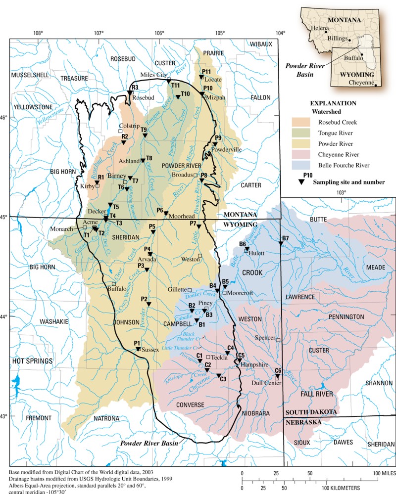
Figure 1. Location of sampling sites proposed in the Water Task Group's surface-water-monitoring plan for the Powder River Basin.
Table 1. Sampling sites proposed in the Water Task Group’s surface-water-monitoring plan for the Powder River Basin.
| Map number | U.S. Geological Survey site number | Site name | Stream type |
|---|---|---|---|
| R1 | 06295113 | Rosebud Creek at reservation boundary near Kirby, Mont. | Mainstem |
| R2 | 06295250 | Rosebud Creek near Colstrip, Mont. | Mainstem |
| R3 | 06296003 | Rosebud Creek at mouth, near Rosebud, Mont. | Mainstem |
| T1 | 06299980 | Tongue River at Monarch, Wyo. | Mainstem |
| T2 | 06305700 | Goose Creek near Acme, Wyo. | Tributary |
| T3 | 06306250 | Prairie Dog Creek near Acme, Wyo. | Tributary |
| T4 | 06306300 | Tongue River at State line near Decker, Mont. | Mainstem |
| T5 | 06307500 | Tongue River at Tongue River Dam, near Decker, Mont. | Mainstem |
| T6 | 06307600 | Hanging Woman Creek near Birney, Mont. | Tributary |
| T7 | 06307616 | Tongue River at Birney Day School Bridge, near Birney, Mont. | Mainstem |
| T8 | 06307740 | Otter Creek at Ashland, Mont. | Tributary |
| T9 | 06307830 | Tongue River below Brandenberg Bridge, near Ashland, Mont. | Mainstem |
| T10 | 06308400 | Pumpkin Creek near Miles City, Mont. | Tributary |
| T11 | 06308500 | Tongue River at Miles City, Mont. | Mainstem |
| P1 | 06313500 | Powder River at Sussex, Wyo. | Mainstem |
| P2 | 06313605 | Powder River below Burger Draw, near Buffalo, Wyo. | Mainstem |
| P3 | 06316400 | Crazy Woman at Upper Station, near Arvada, Wyo. | Tributary |
| P4 | 06317000 | Powder River at Arvada, Wyo. | Mainstem |
| P5 | 06324000 | Clear Creek near Arvada, Wyo. | Tributary |
| P6 | 06324500 | Powder River at Moorhead, Mont. | Mainstem |
| P7 | 06324970 | Little Powder River above Dry Creek, near Weston, Wyo. | Tributary |
| P8 | 06325500 | Little Powder River near Broadus, Mont. | Tributary |
| P9 | 06325650 | Powder River near Powderville, Mont. | Mainstem |
| P10 | 06326300 | Mizpah Creek near Mizpah, Mont. | Tributary |
| P11 | 06326500 | Powder River near Locate, Mont. | Mainstem |
| C1 | 06364300 | Porcupine Creek near Teckla, Wyo. | Tributary |
| C2 | 06364700 | Antelope Creek near Teckla, Wyo. | Tributary |
| C3 | 06365900 | Cheyenne River near Dull Center, Wyo. | Mainstem |
| C4 | 06375600 | Little Thunder Creek near Hampshire, Wyo. | Tributary |
| C5 | 06376300 | Black Thunder Creek near Hampshire, Wyo. | Tributary |
| C6 | 06386500 | Cheyenne River near Spencer, Wyo. | Mainstem |
| B1 | 06425720 | Belle Fourche River below Rattlesnake Creek near Piney, Wyo. | Mainstem |
| B2 | 06425800 | Caballo Creek near Gillette, Wyo. | Tributary |
| B3 | 06425900 | Caballo Creek at mouth, near Piney, Wyo. | Tributary |
| B4 | 06426400 | Donkey Creek near Moorcroft, Wyo. | Tributary |
| B5 | 06426500 | Belle Fourche River below Moorcroft, Wyo. | Mainstem |
| B6 | 06428050 | Belle Fourche River below Hulett, Wyo. | Mainstem |
| B7 | 06428500 | Belle Fourche River at Wyoming-South Dakota State line | Mainstem |
Table 2. General sampling strategy proposed in the Water Task Group’s surface-water-monitoring plan for the Powder River Basin.
| Stream type | Sampling frequency | Constituent class |
|---|---|---|
| Mainstem | Continuous | Streamflow |
| 12 times per year | Field measurements | |
| 12 times per year | Major ions | |
| 2 times per year | Nutrients | |
| 12 times per year | Trace elements, primary | |
| 2 times per year | Trace elements, secondary | |
| 12 times per year | Suspended sediment | |
| Tributary | Continuous | Streamflow |
| 6 times per year | Field measurements | |
| 6 times per year | Major ions | |
| 2 times per year | Nutrients | |
| 6 times per year | Trace elements, primary | |
| 2 times per year | Trace elements, secondary | |
| 6 times per year | Suspended sediment |
Because of funding shortfalls for surface-water monitoring, only part of the proposed sampling in the surface-water-monitoring plan was accomplished during 2005 (table 3). For the sites where the sampling was partially completed, either the sampling frequency was less than the proposed sampling frequency or not all of the constituent classes were analyzed. The Tongue River watershed was the only watershed where the sampling proposed in the surface-water-monitoring plan was fully completed.
Several of the agencies that participate on the PRB IWG contributed funding for monitoring and reporting, including:
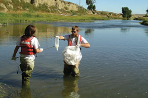
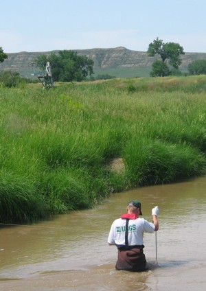
Streamflow data and water-quality samples were collected by USGS personnel using standard USGS field methods (http://water.usgs.gov/owq/FieldManual/). Samples were analyzed at the USGS National Water Quality Laboratory in Lakewood, Colorado.
Table 3. Monitoring accomplished for surface-water-monitoring plan during 2005.
[C, completed; P, partially completed; and N, not completed.]
| Map number | Stream-flow |
Field measurements |
Major ions |
Nutrients |
Trace elements, primary |
Trace elements, secondary |
Suspended sediment |
|---|---|---|---|---|---|---|---|
| R1 | C |
C |
C |
C |
C |
P |
C |
| R2 | C |
N |
N |
N |
N |
N |
N |
| R3 | C |
P |
P |
P |
P |
P |
P |
| T1 | C |
C |
C |
C |
C |
C |
C |
| T2 | C |
C |
C |
C |
C |
C |
C |
| T3 | C |
C |
C |
C |
C |
C |
C |
| T4 | C |
C |
C |
C |
C |
C |
C |
| T5 | C |
C |
C |
C |
C |
C |
C |
| T6 | C |
C |
C |
C |
C |
C |
C |
| T7 | C |
C |
C |
C |
C |
C |
C |
| T8 | C |
C |
C |
C |
C |
C |
C |
| T9 | C |
C |
C |
C |
C |
C |
C |
| T10 | C |
C |
C |
C |
C |
C |
C |
| T11 | C |
C |
C |
C |
C |
C |
C |
| P1 | C |
C |
C |
N |
P |
N |
N |
| P2 | N |
C |
C |
N |
P |
N |
N |
| P3 | C |
C |
C |
C |
P |
N |
C |
| P4 | C |
C |
C |
N |
P |
N |
N |
| P5 | C |
C |
C |
N |
P |
N |
N |
| P6 | C |
C |
C |
C |
C |
C |
C |
| P7 | C |
C |
C |
C |
P |
P |
C |
| P8 | N |
C |
C |
C |
C |
C |
C |
| P9 | N |
N |
N |
N |
N |
N |
N |
| P10 | N |
N |
N |
N |
N |
N |
N |
| P11 | C |
C |
C |
C |
C |
C |
C |
| C1 | C |
C |
C |
N |
P |
N |
N |
| C2 | N |
C |
C |
N |
P |
N |
N |
| C3 | C |
C |
C |
N |
P |
N |
N |
| C4 | N |
C |
C |
N |
P |
N |
N |
| C5 | N |
C |
C |
N |
P |
N |
N |
| C6 | C |
C |
C |
N |
P |
N |
N |
| B1 | N |
C |
C |
N |
P |
N |
N |
| B2 | N |
C |
P |
N |
N |
N |
N |
| B3 | N |
C |
C |
N |
P |
N |
N |
| B4 | N |
C |
C |
N |
P |
N |
N |
| B5 | C |
C |
C |
C |
P |
N |
N |
| B6 | N |
C |
C |
C |
P |
N |
N |
| B7 | C |
N |
N |
N |
N |
N |
N |
Data collected as part of Water Task Group surface-water-monitoring plan are stored electronically in the USGS National Water Information System. Continuous streamflow and water-quality data are available to the public at URL: http://waterdata.usgs.gov/nwis/. Other USGS data for Montana and Wyoming can be accessed at http://mt.water.usgs.gov/, http://tonguerivermonitoring.cr.usgs.gov/, and http://wy.water.usgs.gov/.
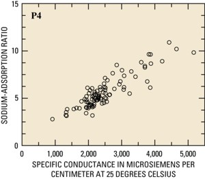
| Another objective of the Water Task Group is to interpret the surface-water-monitoring data that are collected. Until more data are collected, much of the initial interpretive analysis may focus on sites with historical data that were collected for previous monitoring programs. For example, the Powder River at Arvada, Wyoming has been sampled for many years, and relations between constituents, such as specific conductance and the sodium-adsorption ratio, have been established (fig. 2). If the monitoring data indicate that water quality is changing, managers can use adaptive management and appropriate mitigation measures to address environmental concerns. |
Figure 2. Specific conductance and sodium-adsorption ratio relation for the Powder River at Arvada, Wyo. |
For more information, contact:Water Science Center Director, Water Science Center Director, Field Office Manager, Field Office Manager, |
 |
Layout by Suzanne C. Roberts
For additional information on the water quality of the Powder River Basin watersheds, visit the USGS Web site at http://wy.water.usgs.gov/
or contact
Director of the USGS Wyoming Water Science Center 2617 E. Lincolnway, Suite B Cheyenne, Wyoming 82001 (307) 775-9162 Email: state_rep_wy@usgs.gov