 |
|
|
||||
| Publications—Fact Sheet 2005-3143 |
| In cooperation with Upper Arkansas Water Conservancy District Sustainability of Ground-Water Resources in the Upper Arkansas River Basin between Buena Vista and Salida, Colorado, 2000–2003Available from the U.S. Geological Survey, Branch of Information Services, Box 25286, Denver Federal Center, Denver, CO 80225, USGS Fact Sheet 2005-3143. This document also is available in pdf format: The citation for this report, in USGS format, is as follows: Watts, K.R., 2005, Sustainability of Ground-Water Resources in the Upper Arkansas River Basin between Buena Vista and Salida, Colorado, 2000–2003: U.S. Geological Survey Fact Sheet 2005-3143, 4 p. IntroductionGround water is an important part of the water supply in the arid and
semiarid mountains of the Southwestern United States, which is increasingly
stressed by continued population growth. Between Ground-water sustainability can be defined as the development and use of ground water in a manner that can be maintained for an indefinite time without causing unacceptable environmental, economic, or social consequences (Alley and others, 1999). Ground-water sustainability must be defined within the context of the complete hydrologic system of which ground water is a part. In June 2000, the U.S. Geological Survey (USGS), in cooperation with
the Upper Arkansas Water Conservancy District (UAWCD), began a study of
ground water in the upper Arkansas River Basin from Buena Vista to Salida,
Colorado. One of the goals of the study was to evaluate the effects of
increased ground-water use on ground-water sustainability. The results
from that study (Watts, 2005) will assist the UAWCD in developing an overall
strategy to prevent excessive drawdown of water levels at existing wells,
ground-water depletion, water-quality degradation, and the drying up of
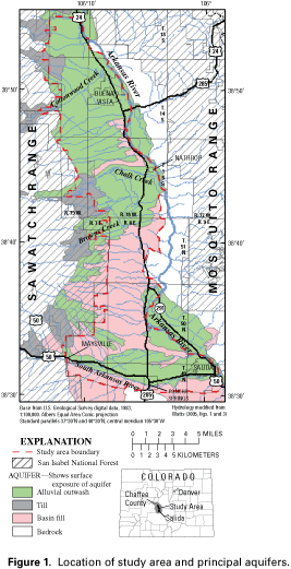
springs, wetlands, and riparian areas. The study area is in the upper Arkansas River Basin between Buena Vista and Salida, in Chaffee County, Colorado (fig. 1). The upper Arkansas River Basin is an intermountain basin flanked by the Sawatch and Mosquito Ranges. The study area is about 149 square miles (mi2) and includes that part of the basin that is underlain by alluvial, glacial, and basin-fill deposits and that lies between the Arkansas River and the San Isabel National Forest in the Sawatch Range. The alluvial-outwash and the basin-fill aquifers are the primary sources of water for domestic and municipal wells in the study area. The alluvial-outwash aquifer consists of less than 500 feet (ft) of permeable sand and gravel with silt and clay lenses. The basin-fill aquifer underlies the alluvial-outwash aquifer and consists of as much as 5,000 ft of interbedded clay, silt, sand, and gravel and is less permeable than the alluvial-outwash aquifer. The till and bedrock aquifers are the principal sources for domestic water supplies in the mountainous areas flanking the study area. Because 95 percent of the wells in Chaffee County are less than 300 ft deep, little is known about the aquifers at greater depths (Watts, 2005). Recharge and Discharge The aquifers of the study area primarily are recharged by losing streams that flow across permeable alluvium and outwash near the western side of the study area and by infiltration of surface water diverted for irrigation. Precipitation in the study area from 1948 to 2003 averaged about 10 inches per year (in/yr). Infiltration of precipitation provides minimal recharge to the aquifers. Return flow from domestic water supplies through septic systems is assumed to equal 90 percent of withdrawals and is a relatively small source of recharge. Ground water discharges to streams near the eastern side of the study area and to the Arkansas River and South Arkansas River. The amount of recharge to and discharge from the aquifers is not known. During the drought of 2002, precipitation in and streamflow (runoff) from the Sawatch Range into the study area were much less than normal, and there was little recharge to aquifers from losing streams or from infiltration of surface-water diversions. Consequently, water levels in the aquifers declined as much as 40 ft (Watts, 2005). With the return to more normal precipitation and runoff conditions in 2003, water levels in most of the study area recovered to near pre-2002 levels. Most ground-water use in Chaffee County is for municipal and domestic supply. During 2003, domestic wells supplied water for about 53 percent of the population of Chaffee County. Water for the rest of population is provided by municipal systems, which use either ground water or a combination of ground water and surface water. The estimated annual rate of self-supplied ground-water (domestic) use in Colorado ranges from 0.2 to 0.36 acre-foot per year (acre-ft/yr) per household (Waskom and Neibauer, 2005), which is equivalent to a range of average daily use of about 180 to 320 gallons per household. The estimated combined volume of annual withdrawal during 2003 by the estimated 3,443 domestic wells in Chaffee County was 690 to 1,240 acre-ft. By 2030, the combined annual withdrawal for the existing 3,443 wells plus the 4,000 to 5,000 new wells is projected to be 1,490 to 3,040 acre-ft/yr (Watts, 2005). Ground-Water Storage The availability of ground water (volume of drainable ground water stored
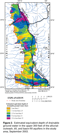
within 300 ft of land surface) was estimated, using a geographic information
system (GIS), as the product of aquifer area, The equivalent depth of drainable ground water within 300 ft of land surface during September 2003 is the estimated volume of drainable ground water divided by area (fig. 2). The equivalent depth of drainable ground water ranged from less than 1 to about 15 ft (fig. 2). Generally, where the alluvial-outwash aquifer is the uppermost aquifer (fig. 1) and depths to water are within 25 to 100 ft of land surface, the equivalent depth of drainable ground water is 10 to 15 ft (fig. 2). Where the basin-fill aquifer (fig. 1) is the uppermost aquifer or in areas where the depth to water in the alluvial-outwash aquifer was large, the equivalent depth of drainable ground water generally was less than 5 ft. The equivalent depth of drainable ground water was less than 1 ft near the southern and western sides of the study area and along topographic divides west-northwest of Salida. Wells in areas with less than 1 ft of drainable ground water likely would have to be drilled deeper than 300 ft. The volume of drainable ground water within 300 ft of land surface that is available to supply a proposed well can be estimated from figure 2, by multiplying the equivalent depth of drainable ground water by the area of interest. For example, the volume of drainable ground water underlying a 35-acre parcel can be calculated as the product of the area (35 acres) and the equivalent depth of drainable water. Assuming an equivalent depth of drainable ground water of 2 ft, the volume of drainable water underlying the 35-acre parcel is 70 acre-ft (35 acres * 2 ft = 70 acre-ft). If the proposed well is anticipated to pump acre-ft/yr, pumping by the well could deplete the available ground water within 300 ft of the surface in 70 years, assuming that the aquifer in that area received no additional recharge. Potential Effects of Increased Pumping Pumping of ground water by wells causes changes in recharge to, discharge from, and storage in aquifers. As a well begins pumping from an aquifer, water initially is removed from storage in the well and in the aquifer near the well. Ultimately, the water discharged by a well is supplied by increasing recharge, by decreasing discharge, by decreasing aquifer storage, or, most likely, by a combination of these processes (Alley and others, 1999, p. 18). The possible effects of the ground-water withdrawals by an additional 4,000 to 5,000 domestic wells could include streams and rivers and capture of ground water that normally discharges to streams and rivers), capture of ground water that normally discharges to springs and wetlands, and depletion of ground-water storage. Unintended consequences that could result, if ground-water depletion occurs, include increased pumping costs, decreased well yield, and replacement of existing wells that are too shallow or no longer provide sufficient yield. Streamflow Depletion by Wells and Augmentation Where streams and aquifers are hydraulically connected, pumping a well can cause streamflow depletion. Augmentation plans are required for most wells in the study area to replace (to streams) that part of ground-water withdrawal that is consumptively used. Consumptive use for domestic wells in the area is assumed to equal 10 percent of ground-water withdrawal. Consumptive use for current (2003) domestic use is an estimated 69 to 124 acre-ft/yr and for projected (2030) domestic use is an estimated 149 to 304 acre-ft/yr (Watts, 2005). The UAWCD augmentation plan, which includes about 700 wells, supplied about 116 acre-ft of augmentation water in 2003 to offset stream depletions (Upper Arkansas Water Conservancy District, 2004). An estimated 800 to 1,200 other wells in the area had individual augmentation plans (Terry Scanga, Upper Arkansas Water Conservancy District, Salida, Colorado, written commun., January 12, 2005). The water replaced to streams through augmentation plans is designed to offset stream depletion not prevent ground-water depletion. Ground-water depletion still can occur in parts of the study area that are distant from recharge areas (losing streams or areas irrigated with surface-water diversions). Ground-water depletion in these areas primarily will be related to the number of wells and pumping rates. Well Density and Well Interference Where wells are densely spaced, ground-water availability and sustainability
may be affected by interference between wells. Well interference can cause
increased drawdown at pumping wells, which may result in increased pumping
costs, The potential for excessive drawdown resulting from well interference in areas with high well density is greater in areas in which wells are completed in the basin-fill aquifer than it is in areas in which wells are completed in the alluvial-outwash aquifer. In general, the alluvial-outwash aquifer has more ground water in storage than the basin-fill aquifer because its specific yield is larger. In addition, the alluvial-outwash aquifer generally is more permeable and more directly recharged by losing streams and surface-water diversions. Watts (2005, fig. 17) showed that drawdown caused by pumping hypothetical domestic wells that are completed in the basin-fill aquifer could be about 30 to 50 times greater than similar wells that are completed in the alluvial-outwash aquifer. Summary and Conclusions Ground water is and will continue to be an important source for domestic water supplies in Chaffee County. As the countys population increases, additional wells likely will be drilled, and more stress will be placed on the ground-water resources to meet the increasing water demand. A preliminary assessment of ground-water availability and sustainability in the upper Arkansas River Basin between Buena Vista and Salida, Colorado, indicates that current (2003) and projected (2030) ground-water withdrawals are less than 1 percent of the drainable ground water stored in the upper 300 feet of the subsurface. In general, pumping by domestic wells likely is sustainable at projected rates; however, ground-water depletion could occur where withdrawals are large and when there is little recharge. Additional ground-water monitoring may be needed in areas with a high density of domestic wells or where large-capacity wells are used to supply multiple households because increased ground-water withdrawals may cause local depletion of ground-water storage. By K.R. Watts References Alley, W.M., Reilly, T.E., and Franke, O.L., 1999, Sustainability of Ground-Water Resources: U.S. Geological Survey Circular 1186, 79 p. Colorado Water Conservation Board, 2004, Update on Statewide water supply initiative - Arkansas Basin: Colorado Water Conservation Board, 7 p. [Accessed August 16, 2004 at URL http://cwcb.state.co.us/SWSI/Basin_Fact_Sheets/Arkansas_SWSI_Update_8-02-04.pdf]. Upper Arkansas Water Conservancy District, 2004, 2004 Annual report of augmentation: Salida, Colorado, Upper Arkansas Water Conservancy District, 3 p. Waskom, R., and Neibauer, M., 2005, Water conservation in and around the home: Fort Collins, Colorado State University Cooperative Extension [Accessed November 17, 2005 at URL http://www.ext.colostate.edu/pubs/consumer/09952.html]. Watts, K.R., 2005, Hydrogeology and quality of ground water in the upper Arkansas River Basin from Buena Vista to Salida, Colorado, 2000-2003: U.S. Geological Survey Scientific Investigations Report 2005-5179, 61 p. FOR ADDITIONAL INFORMATION PLEASE CONTACT Patrick Edelmann |
| AccessibilityFOIAPrivacyPolicies and Notices | |
 |
|
 1980 and 2000, the population of Chaffee County, in the upper Arkansas
River Basin of Colorado (fig. 1), increased about 23 percent to 16,000
people and is projected to increase an additional 70 percent by 2030 (Colorado
Water Conservation Board, 2004). Individual domestic wells likely will
be used to supply the growing population of the upper Arkansas River Basin
because surface-water supplies already are appropriated and most population
growth likely will be in areas that are not served by municipal water
supplies. Planners and resource managers need an improved understanding
of the hydrogeology of the ground-water system to evaluate the potential
effects of increased ground-water withdrawals on the sustainability of
the area’s water resources.
1980 and 2000, the population of Chaffee County, in the upper Arkansas
River Basin of Colorado (fig. 1), increased about 23 percent to 16,000
people and is projected to increase an additional 70 percent by 2030 (Colorado
Water Conservation Board, 2004). Individual domestic wells likely will
be used to supply the growing population of the upper Arkansas River Basin
because surface-water supplies already are appropriated and most population
growth likely will be in areas that are not served by municipal water
supplies. Planners and resource managers need an improved understanding
of the hydrogeology of the ground-water system to evaluate the potential
effects of increased ground-water withdrawals on the sustainability of
the area’s water resources.
 saturated
thickness, and estimated specific yield of the aquifers (Watts, 2005).
The volume of available ground water within 300 ft of the surface varies
locally within the study area because the specific yield and saturated
thickness of the aquifers are variable. Saturated thickness of the upper
300 ft of the subsurface was estimated as the difference between the altitude
of the September 2003 water-table surface (Watts, 2005, fig. 3) and the
altitude of the horizon 300 ft below land surface (land-surface altitude
minus 300 ft). Specific yield, the ratio of the volume of drainable water
to the saturated volume of the aquifer, was estimated from lithologic
logs (drilling reports) from 842 wells. In September 2003, there was an
estimated 472,000 acre-ft of drainable ground water within 300 ft of
land surface in the study area (Watts, 2005, table 8). Under current (2003)
and projected (2030) conditions, annual ground-water withdrawals for domestic
use are less than 1 percent of the estimated 472,000 acre-ft of drainable
water in the upper 300 ft of the subsurface.
saturated
thickness, and estimated specific yield of the aquifers (Watts, 2005).
The volume of available ground water within 300 ft of the surface varies
locally within the study area because the specific yield and saturated
thickness of the aquifers are variable. Saturated thickness of the upper
300 ft of the subsurface was estimated as the difference between the altitude
of the September 2003 water-table surface (Watts, 2005, fig. 3) and the
altitude of the horizon 300 ft below land surface (land-surface altitude
minus 300 ft). Specific yield, the ratio of the volume of drainable water
to the saturated volume of the aquifer, was estimated from lithologic
logs (drilling reports) from 842 wells. In September 2003, there was an
estimated 472,000 acre-ft of drainable ground water within 300 ft of
land surface in the study area (Watts, 2005, table 8). Under current (2003)
and projected (2030) conditions, annual ground-water withdrawals for domestic
use are less than 1 percent of the estimated 472,000 acre-ft of drainable
water in the upper 300 ft of the subsurface.
 decreased well yields, and ground-water depletion. The density of domestic
wells in and near the study area during 2003 is shown if figure 3. Well
density is defined as the fractional number of wells per acre and was
computed using GIS and data from the files of the Colorado Division of
Water Resources. The average area per well, in units of acre per well,
can be estimated as the inverse of well density (the number one divided
by the well density). Maximum well density in the study area was about
0.2 to 0.4 well per acre (2.5 to 5 acres per well) in an area near Buena
Vista (fig. 3). At a well density of 0.4 well per acre there would be
256 wells in an area of one square mile.
decreased well yields, and ground-water depletion. The density of domestic
wells in and near the study area during 2003 is shown if figure 3. Well
density is defined as the fractional number of wells per acre and was
computed using GIS and data from the files of the Colorado Division of
Water Resources. The average area per well, in units of acre per well,
can be estimated as the inverse of well density (the number one divided
by the well density). Maximum well density in the study area was about
0.2 to 0.4 well per acre (2.5 to 5 acres per well) in an area near Buena
Vista (fig. 3). At a well density of 0.4 well per acre there would be
256 wells in an area of one square mile.