 |
Sustainability of the Ground-Water Resources in the Atlantic Coastal Plain of Maryland
USGS Fact Sheet FS 2006-3009
A 2004 report by the Advisory Committee on the Management and Protection of the State's Water Resources identified the need for a comprehensive assessment of ground-water resources of the Maryland Coastal Plain, where the population is expected to grow by 37 percent between the years 2000 and 2030. Accordingly, the Maryland Geological Survey (MGS) and the U.S. Geological Survey (USGS) have begun the first phase of a three-phase assessment of Maryland's Coastal Plain aquifer system. This Fact Sheet describes this assessment and the current and planned activities necessary for its implementation.
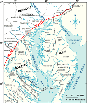 |
Figure 1: Extent of the Atlantic Coastal Plain in Maryland and adjacent states. |
Importance of Ground Water in the Atlantic Coastal Plain of Maryland
Ground water is the primary source of water supply in most areas of Maryland within the Atlantic Coastal Plain (fig. 1), and is pumped from sand and gravel layers underlying the Coastal Plain. These sand and gravel layers alternate with layers of silt and clay to form a wedge-shaped system of sediments that begins at the Fall Line (the boundary between the Atlantic Coastal Plain and the Piedmont Physiographic Provinces) and gently tilts and thickens to the southeast toward the Atlantic Ocean (fig. 2). The buried sands and gravels form a sequence of confined aquifers that is overlain by sandy deposits that form a surficial aquifer. These aquifers are the primary water supply for southern Maryland and the Eastern Shore.
Why is this Assessment Necessary?
Water Levels in the Aquifers are Declining at a Significant Rate
Withdrawals from Maryland Coastal Plain aquifers have caused ground-water levels in confined aquifers to decline by tens to hundreds of feet from their original levels (fig. 3). The current rate of decline in many of the confined aquifers is about 2 feet per year. The declines are especially large in southern Maryland and parts of the Eastern Shore, where ground-water pumpage is projected to increase by more than 20 percent between the years 2000 and 2030, with some regions experiencing significantly greater increases. Continued water-level declines at current rates could affect the long-term sustainability of ground-water resources in Maryland’s heavily populated Coastal Plain communities and the agricultural areas of the Eastern Shore.
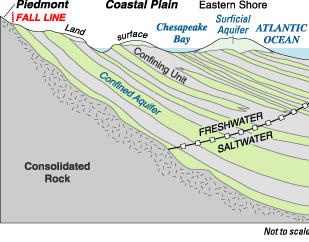 |
Figure 2: Schematic of the Atlantic Coastal Plain aquifer system in the southern Maryland |
2) Water Quality in Some Areas is Significantly Compromised
Water quality in the Coastal Plain aquifers is a concern for several reasons. Contamination by saltwater intrusion is a significant water-quality issue for the confined aquifers, and has been documented in several of Maryland’s waterfront communities. However, the potential for saltwater intrusion is not well known in the deeper parts of the aquifer system because few data are available. Some areas have problems with naturally high concentrations of trace-element contaminants (including arsenic and radium), and further evaluation of these public health issues is warranted. Elevated concentrations of nutrients and agricultural chemicals in the surficial aquifer is a significant concern, especially on the Eastern Shore, where shallow ground water is the water-supply source for many homeowners and provides much of the base flow to streams.
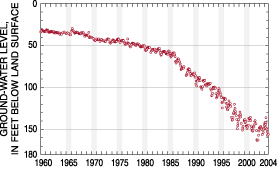 |
Figure 3: Hydrograph showing declining water levels in a well in the Aquia Aquifers in Southern Maryland. |
3) Ground-Water Resource Managers Need Better Tools
Water managers, policymakers, planners, and developers need to know how much ground water is available in the different areas of the Maryland Coastal Plain for public and domestic water supply, agriculture, industry, and electric power generation. Ground-water withdrawals in Maryland are managed by the Maryland Department of the Environment (MDE) through the Water Appropriations Permit Program. While studies of individual aquifers or multi-aquifer subregions are available, MDE needs more comprehensive and interactive tools for making management and permitting decisions. Specifically, MDE needs information systems and simulation tools to evaluate the effects of increased withdrawals on the entire aquifer system in important subregions and throughout the Maryland Coastal Plain. These tools need to take into account that some of the aquifers are units of a regional system that extends into and is used for water supply in adjacent states.
Evaluation of alternative water-management strategies requires enhancements in the monitoring networks for ground-water levels and streamflow throughout the Coastal Plain. Water managers and planners need to understand where and when continued withdrawal of ground water may reduce streamflow and/or induce changes in water quality that would require additional treatment or limit uses of the water resource.
Plans for the Comprehensive Assessment of the Coastal Plain Aquifer System in Maryland
In response to the Advisory Committee’s 2004 report recommendations, MGS and USGS are preparing a science plan and implementation plans for conducting a comprehensive regional assessment of the Coastal Plain aquifers in Maryland and appropriate areas of surrounding states.
Comprehensive Assessment is Underway
MGS and USGS started Phase I of the Comprehensive Assessment in January 2006. Phase I activities are being jointly supported by funds and services from MDE, MGS, and USGS. Phases II and III of the assessment will require significant additional investment from current and new funding partners from 2008 to 2013.
Goals of the Assessment |
|
| Implementation Plans | ||
PHASE I |
PHASE II |
PHASE III |
|
|
|
For more information about USGS activities in Maryland, Delaware and the District of Columbia contact:
Director
MD-DE-DC Water Science Center
U.S. Geological Survey
8987 Yellow Brick Road
Baltimore, MD 21237
Telephone: (410) 238-4200
Fax: (410) 238-4210
or access the USGS Water Resources of Maryland, Delaware, and District of Columbia home page at: http://md.water.usgs.gov/.
Maintainer:webmaster@md.water.usgs.gov
USGS Fact Sheet FS 2006-3009

![]() U.S. Department of the Interior | U.S. Geological Survey
U.S. Department of the Interior | U.S. Geological Survey
Persistent URL: https://pubs.water.usgs.gov/fs2006-3009
Page Contact Information: USGS Publishing Network
Page Last Modified: Tuesday, 29-Nov-2016 17:23:51 EST